Trail conditions, May 8
Summary
- TRAILS: The lower elevations are basically clear, even after two small precipitation events last week and then earlier this week. Though the lower elevations are clear, at least one section of trail is still dangerous enough that most hikers won’t be comfortable with it, and should not attempt it at this time.
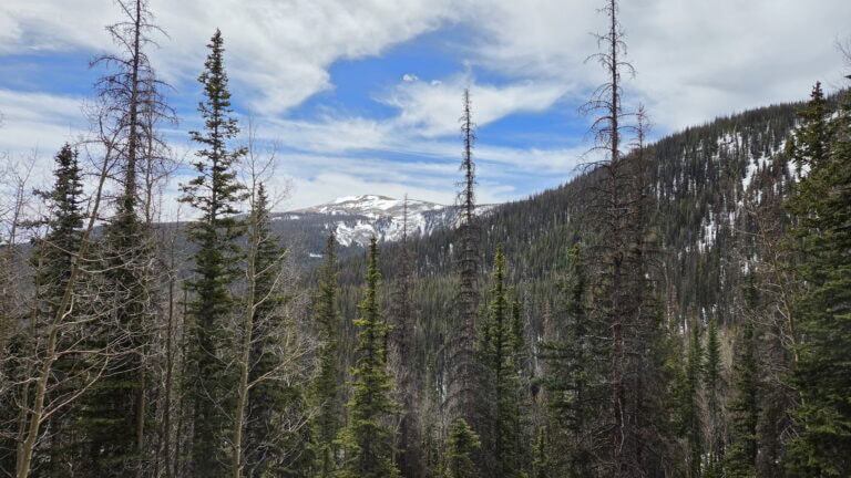
- RECENT / UPCOMING PRECIP: As you can see from the header photo, the highest elevations got some snow and holding on to that snow at least for now. I’m guessing they picked up about a foot or more of snow from the recent two little storms. Sipapu got 5 inches from the first storm last week, but when I was there yesterday the slopes looked pretty much clear already.
- FIRE: Stage 1 fire restrictions are still in effect for both forests. There are no active wildfires in northern New Mexico at this time.
- WATER: We are still in spring runoff, so water sources at the moment are fine, but only in the context of water carries and the basic question of “is this or that water source okay?” Water flows compared to what they should be at this time of year are very bad, with USGS stream monitors showing discharge levels “extremely below” average. Day before yesterday the Rio Grande Del Rancho Near Talpa, NM USGS monitor was showing the “All-time low for this day of year” status. Like the rest of the West, we are in a dire situation with water this year.
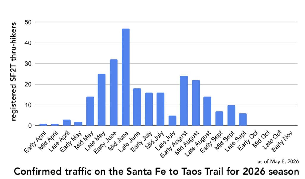
- TRAFFIC: People have started doing the SF2T, but traffic is still very light. Two hikers were going to start from Taos last week but delayed their trip because of the storm coming in, which had been predicted to bring up to 14 inches of new snow. I know of two groups (of one person each) that are on trail at this time.
Trails
This is what the switchbacks on the north side of Lake Katherine looked like early last week.
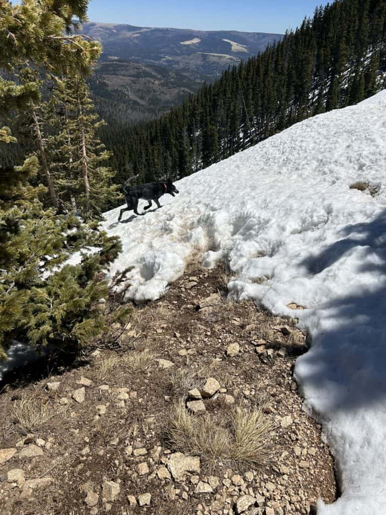
The hiker who took these opted not to continue on to Lake Katherine because of the crusty, slippery snow here. These switchbacks are steep; they’re closed to horses because a horse fell on them a decade or so ago and continued down the slope to its death. That happened in summer. I’ll let you conclude what getting across these with slick snow would be like. It’s certainly doable with spikes and poles and patience… but unless you’ve got a whiff of a death wish, it might be wise to wait until these have melted more to attempt them. [Insert my standard comment about how it’s one thing to endanger yourself; it’s another thing to endanger the search and rescue teams that have to go get you.]
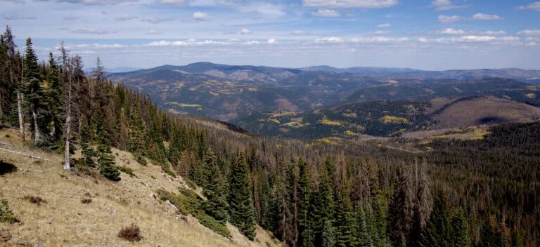
Santa Fe Baldy, however, was clear enough to summit when these were taken. So was Tesuque Peak if you go via Aspen Vista.
Temperatures will be significantly warmer going forward, which may melt this section by even next week, or around May 15th. No way to know without going out there and checking. Also, if these switchbacks are hazardous, the even larger and steeper switchbacks on the north side of the Santa Barbara Divide are likely worse. But again: warmer temperatures are here, and New Mexico sun is excellent for melting snow. These might be clear by early next week.
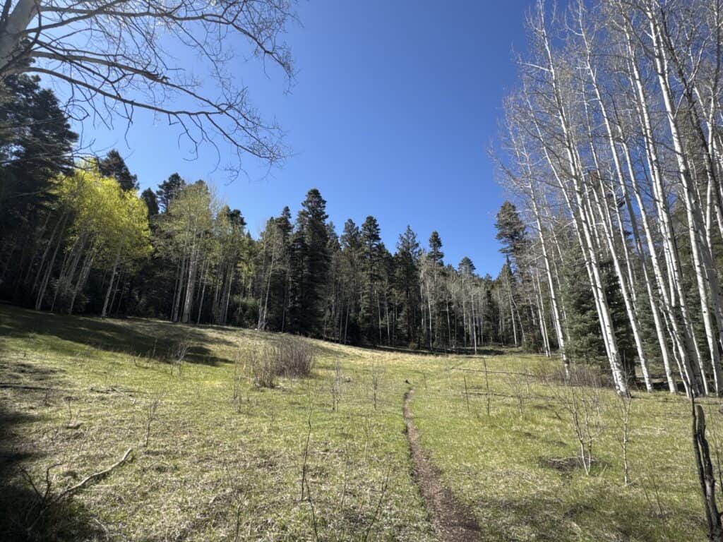
The lower elevations are all clear. This is along Gallegos Trail, approximately 9,800 ft elevation, near Sipapu, yesterday.
Trail maintenance
Known “hitches” (work crews) on the SF2T route in 2026 so far:
- NMWild will be clearing blowdown from Stewart Lake all the way to Pecos Baldy Lake on Skyline Trail. So they will be going along Skyline, past the Bernardin Lake trail to Cave Creek, then taking a left up towards Horsethief Meadow, crossing the meadow into the Jaroso fire burn scar, continuing along Skyline to cross Panchuela Creek (a tiny unburnt haven, excellent to camp or rest in if you’re braving this section of trail), then continuing out of the burn to the Rito Perro trail intersection, then up over the hill on Skyline to come out at the East Pecos Baldy saddle and then going down Skyline to the Pecos Baldy lake basin. Brave crew! If this epic clearing event succeeds, we may have a new alternate route along Skyline between Pecos Baldy and Horsethief Meadow.
- NMVFO (New Mexico Volunteers for the Outdoors) has gotten approval to clear Indian Creek Trail (27), Section 4-2 of the SF2T route. This is the roughest section of trail on the SF2T route. There’s a lot of blowdown, there’s no well-defined track, there are springs and wet areas in places, and the trail has been torn up by cattle. It can be hard to follow. It’s also much higher up than it feels (11,400 ft elevation), because you’re under an evergreen canopy.
People often get into trouble on this section of trail. A 30-year-old trail runner from the east coast had to be taken off trail one day in due to altitude sickness here. One of last year’s thru-hikers had a very tough time as well, and I suspect had altitude sickness while she went through here, too. Really happy to be getting this cleaned up.
Recent / Upcoming precipitation
As mentioned, it’s about to get much warmer in the high country. Like lows in the low 40s high 30s and highs in upper 50s low 60s. There is some possible rain – 30% chance – a couple of days next week.
See the summary for details about the snow last week. It was so, so, so good to see snow on the mountains for a few days. Gave me the lovely temporary illusion of things being normal.
Fire
Carson went into Stage 1 fire restrictions on April 24th. Those are set to continue through September 30th unless rescinded (just like Santa Fe NF’s). Carson’s fire restrictions page is here. Santa Fe National Forest’s alerts page is here. If you don’t have it already, get the app WatchDuty to monitor wildfire activity while you’re on trail. The City of Santa Fe’s “Alert Santa Fe” email notifications are pretty good, too.
This map of wildfire risk is interesting. These are from the National Interagency Fire Center.
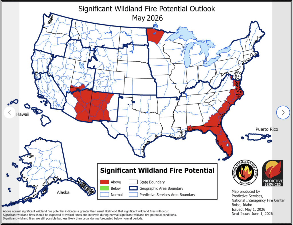
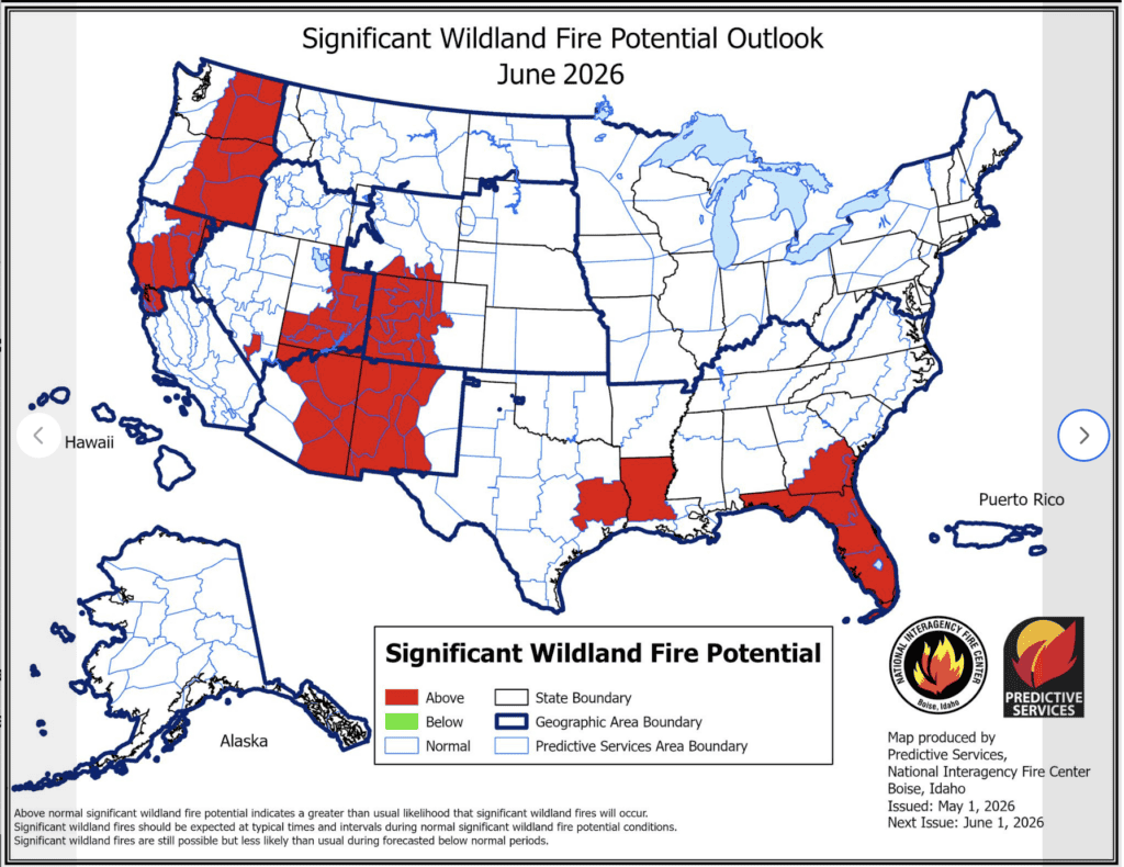
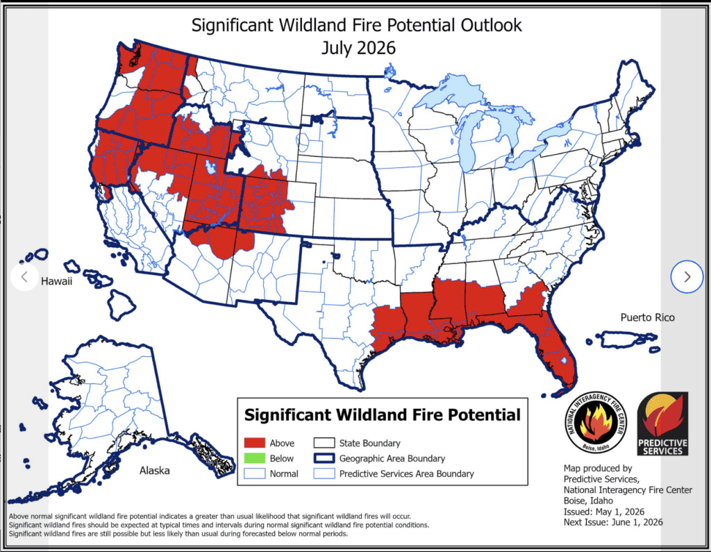
Would not surprise me one jot if the woods were closed in June due to fire conditions. It’s already been a bad year for wildfire across the country.
Interesting article: Fire is transforming the US West’s public lands – research shows overlooked cost to recreation.
Water
Here’s the USGS map of New Mexico monitoring locations.
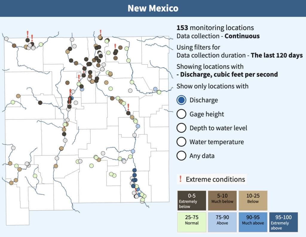
The image below is from the day before yesterday for the Rio Grande del Rancho location near Talpa. This is right below where Rio Grande del Rancho and Rito de la Olla merge. It’s before the merge with Rio Chiquito.

So what does it mean? It means… that I wouldn’t be surprised to see sections of these smaller creeks go dry later this year. For hikers, that means, yes – you will have longer water carries. Do note the wildfire maps above, though: They show wildfire danger dropping in July. Which suggests the data indicates that we will get a monsoon. That could turn the worst of this around…? I hope.
Traffic
I know of two people, both going solo, who are doing the SF2T right now. Which means there are probably at least four or more people out on the trail right now. Not too much traffic, but the season has definitely begun.
Agua Piedra Campground in Carson opened today.