

Trail conditions June 18th
This is a hasty post just to give you a few highlights:
- Water conditions
- Hikers wandering into private property along Camino Pequeno
- Blowdown
- Indian Creek Trail alternate
- Panchuela Campground renovations and access
- Four small active fires in the Santa Fe area (but not on or near the SF2T route)
Water conditions
- La Cueva Lake is dry. (Section 4, Carson NF, bit north of Agua Piedra Campground)
- Little Tesuque Creek is dry (Section 1, Santa Fe county land, between Sierra del Norte Trailhead and Little Tesuque Trailhead in Santa Fe). Not Big Tesuque Creek along Winsor Trail – that’s fine. Little Tesuque Creek.
- Everything else is reported as okay.
- Heard earlier today from a hiker: “Everything went well, no surprises along the way. FYI La Cueva Lake is dry. But everything else was wet when I got there. I got a lot of feedback from NOBOs about Little Tesuque Creek being dry. Given that it is the first water supply after leaving Santa Fe, it seemed that threw a lot of folks and made them concerned about the availability of water the rest of the way. I was able to assure them that, apart from La Cueva Lake, the water was where it was supposed to be the rest of the way. Actually, I was a little surprised how wet it was at elevation give the dry winter we had.” He (Scott Burt) is publishing an extended trip report here.
- Heard the day before yesterday from a different hiker: “The water sources were all great. I never needed to carry more than 2 liters.”
Hikers wandering into private property
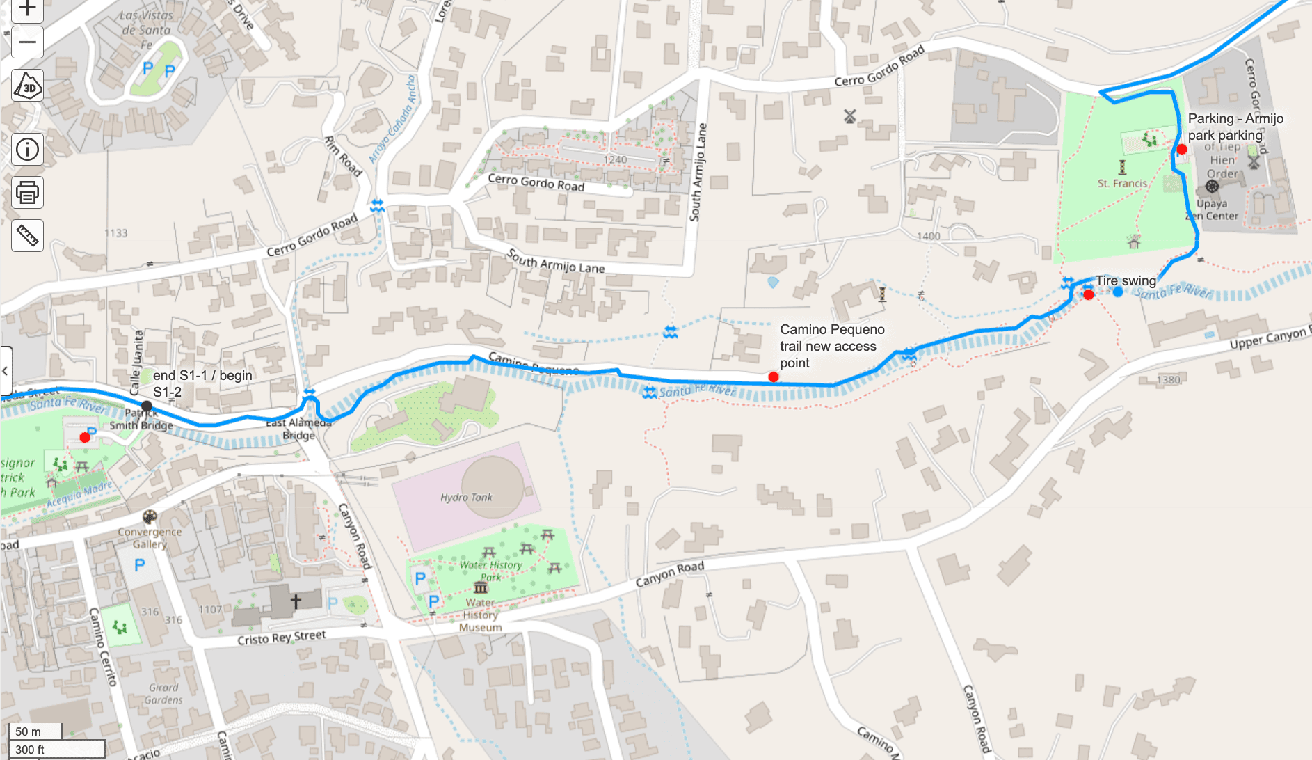
I got a complaint from a property owner along the Camino Pequeno section of the SF2T about people wandering onto her property. More about this later, but DO NOT LEAVE THE TRAIL through Camino Pequeno. If we cannot keep our act together on this, we will lose access to this lovely little walk and will have to use Cerro Gordo Road.
Going forward please do not use the bridge off Camino Pequeno. Instead, walk 0.3 miles in from Alameda. Around 0.25 miles there will be a field on your left. At the far edge of the field there’s a house, then the road bends slightly left. Right where the road bends left, the trail to use bends right. You can’t miss it: It has a bright blue dot sign, and the trail is 8-feet wide and very well worn. Follow that track/trail the whole way through this corridor. Keep the river on your right the whole way. You’ll pass the tire swing on your right, then about 350 feet after that you’ll come to a fence and the left turn up into Armijo Park. Easy peasy. No more wandering, okay? I don’t want to have to walk on Cerro Gordo Road.
Here’s the zoomed-out map of the area around Camino Pequeno:

Here’s a zoomed in map. Click on it to expand it.
Blowdown
I am hearing people on social media and elsewhere asking and commenting about blowdown on the trail. This is what happens when a) you radically defund the Forest Service and b) gravity keeps happening… and c) we continue to lose a lot of trees due to higher temperatures and reduced snowpack.
I think a lot of people with expectations of this being an easy or well-established trail are being attracted to the SF2T. Please remember: This is not a designated trail. The Forest Service does not endorse the SF2T. I am working very hard to develop this into something lasting, but we do not have the infrastructure, the trail crews, the influence, or the funding of, say, the JMT or other established trails. So expect blowdown. If that’s a problem, that’s okay. There are a lot of other trails to hike on. It’s perfectly okay if this is not the trail for you.
I am consoled to hear that some people have no issues with the blowdown. It’s there – they see it. They go over it. It’s not a big deal. From a hiker who finished last week: “I don’t remember blowdown ever being bad. I was honestly expecting it to be worse. I guess my years hiking in the Gila have made me very accustomed to dealing with bad blowdown. Overall I found the route to be easy to navigate and never frustrating.”
Indian Creek Trail Alternate
I am sad to report that Indian Creek Trail (just north of Santa Barbara Campground) will not be getting cleaned up this year. However, I have an alt route for you:

That is from the second edition of the guidebook, which is at the printer. I am not going to get some sleep so I can wake up early and start on the epub file for the second edition. Also need to set up the file delivery and product page for the enhanced gpx file, which also got finished this morning.
Panchuela Campground
Rumor has it that hikers have been able to go through the campground area, which is undergoing renovations at the moment. No camping there, no bathroom access, no trash, no campground host, and no parking… but I have heard from three different parties that they were able to walk out from Cave Creek Trail through Panchuela and over to Cowles.
More about this soon. There have also been very reliable reports that the work should be done by June 30, which is a blink away. I expect to get over there this week to see what’s up.
Four small active fires in the Santa Fe area (but not on or near the SF2T route)
Thanks to the Santa Fe New Mexican for their coverage:
- Firefighters battling blaze in Santa Fe National Forest north of Cañada de los Alamos
- “Tuesday’s fire comes on the heels of two other small fires reported on Santa Fe National Forest lands Monday after a thunderstorm rolled through the region.
The Oso Fire, which was reported on the Española Ranger District along the Rio Del Oso about 2 miles northeast of Chicoma Mountain, was at about one-tenth of an acre as of Tuesday, according to a Forest Service news release.”
“The half-acre Cebolla 2 Fire, located about 1.5 miles west of the Valle San Antonio between Calaveras and Twin Cabins Canyons by the west bank of the Rio Cebolla, was “smoldering in heavy dead-and-down fuels, ponderosa pine and Douglas-fir.””
- “Tuesday’s fire comes on the heels of two other small fires reported on Santa Fe National Forest lands Monday after a thunderstorm rolled through the region.
- Crews fighting fast-growing fire in Jemez Mountains amid red-flag warning
Install the app WatchDuty on your phone before you head into the backcountry.


