
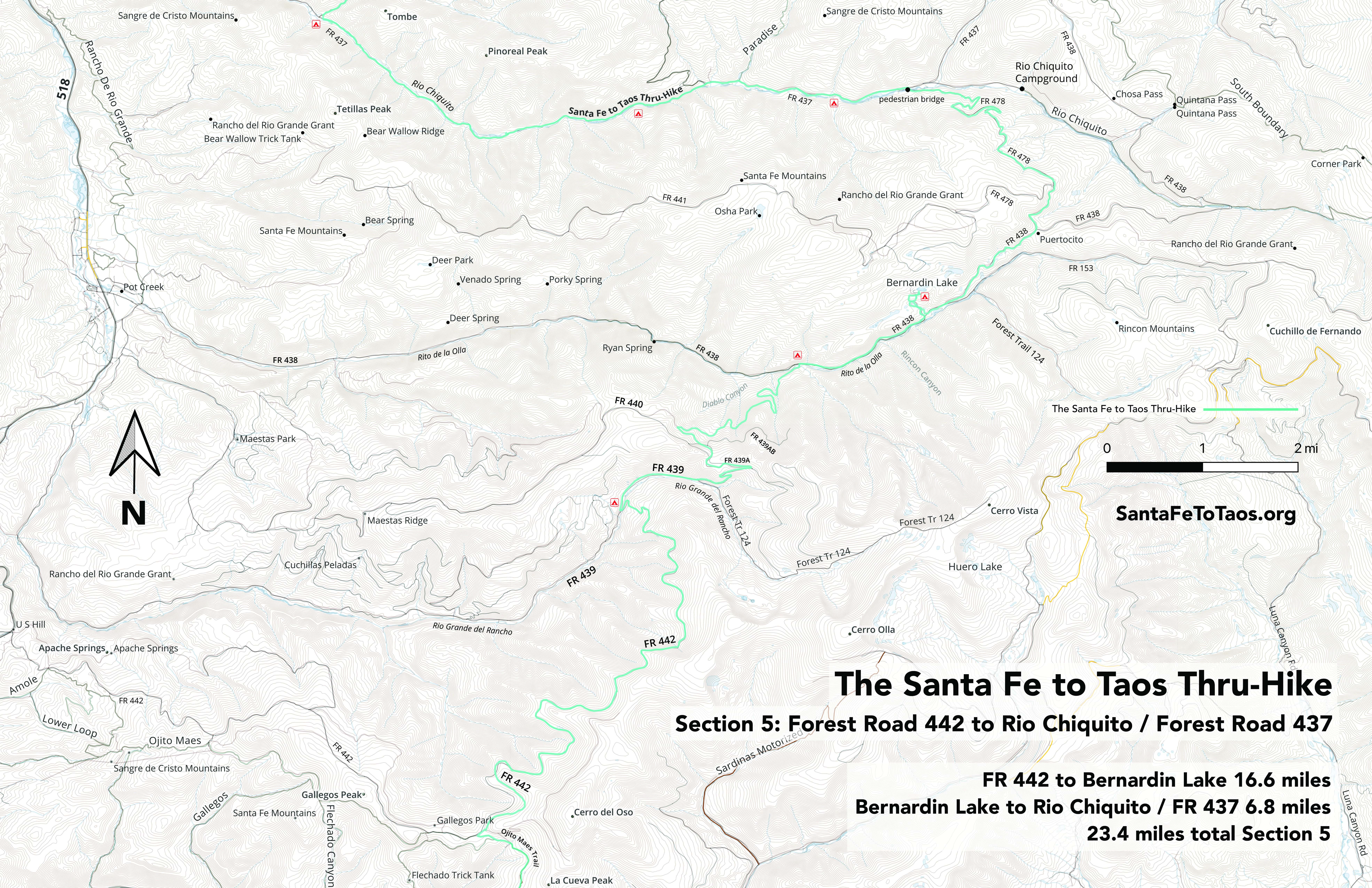
Section 5: FR 442 to Rio Chiquito / FR 437
- S5-1: FR 442 to the beginning of the burn. 4.7 miles.
- S5-2: Beginning of the burn on FR 442 to fr 439 / Rio Grande del Rancho. 4.2 miles.
- S5-3: FR 439 / Rio Grande del Rancho to the beginning of the Connector. 4.0 miles.
- S5-4: The beginning of the Connector to FR 438. 4.0 miles.
- S5-5: FR 438 / end of the Connector to Bernardin Lake. 2.4 miles.
- S5-6: Bernardin Lake to Puertocito (intersection of FR 438 and FR 478). 2.3 miles.
- S5-7: Puertocito to Rio Chiquito / Forest Road 437. 4.5 miles.
- S5 alternate. End of Trail 442 to FR 438 via unnamed ponds to Trail 124 to FR 493A / FR 440. 9.6 miles.
26.1 miles total Section 5

You can download this map for printing. It’s available in legal size (8.5″ x 14″, 12 MB) and in tabloid size (11″ x 17″, 10 MB). The campsites shown on the map are not official campsites.


Text overview of Section 5
S5-1: FR 442 to the beginning of the burn. 4.73 miles.
- Start at the intersection of Trail 442 and Forest Road 442. Then take a right, heading north/northeast and stay on Forest Road 442. You’ll be on it for 8.4 miles. The burn starts around 4.4 miles.
- The water access along here is not ideal. There are a few seeps, but nothing good. You will have good water at the end of the 8.35 miles when you hit the little creek called “Rio Grande del Rancho”. But that’s 8.35 miles without good water. This is the second-longest distance without water for the entire thru-hike. The longest is in Section 6, through Drake Canyon and El Nogal. It’s better than going through the burn on the Colorado Trail (been there, done that, didn’t enjoy it. I’m not the only one.)
- You will be going through shade for almost all of this section. It’s almost entirely evergreens. There are a couple of fields. If you needed to put down a tent, you might have to spend a little time looking for a spot, but they’re around.
- Do note that you are now in the maze-like road system of Carson National Forest. There are forest tracks – probably logging access roads – carved throughout the woods of Carson. You may see several of these tracks going into the woods from FR 442.
- These forest tracks help my personal cause of finding the best route from Santa Fe to Taos, but have a drawback: There are so many of them that it is easier to get lost. And I have yet to find a reliable map of them. Some maps are mostly accurate, but really nothing is completely. Even the Gaia maps I use, with the Gaia classic overlay, will show significant differences between my route (which is me driving in my car for most of this particular section) and where the maps say the roads go. Sorry to say, but my Gaia routes are more accurate than the map. Those routes are not me offroading willy-nilly through the woods, squeezing around trees; they’re me driving on the dirt road that is FR 442.
- Also note that you should not be out here in anything but a high-carriage four-wheel drive vehicle, preferably with upgraded tires. Bring a saw, because fallen trees across the road are not uncommon. I drive a 4Runner, limited edition (because it has beefier undercarriage) with upgraded tires. According to my mechanic, so far I have not damaged my car. Also note that if you do go out on FR 442, don’t try to do it after snowfall, or before the snowpack has had significant time to melt (like late May). In terms of snow and ice, you may be fine so long as you’re on the south side of any given hill, but if you’re on the north side, the snow and ice won’t melt for longer than you’d think. Also seriously consider only going east on FR 442. For example, when you go up on FR 442 from FR 439 / Rio Grande del Rancho, you’ll be driving through the “rio”, which is about 12 feet wide and mostly 6-8 inches deep. But then you’re going right up and over what is basically a boulder embedded in the road. It’s steep enough than when I’m going down 442, I cannot see the road in front of my car for a few moments. All this may be unnecessary clamoring if you’ve got a good work truck or a jeep and you’re used to being out on rough forest roads. I am mostly clamoring for the sake of those of you in, say, Subarus, who think “oh, it can’t be that bad, it’s May for goodness sake, it’s warm and all the snow has melted around Taos, let’s just go.” So this is your warning. There is almost no cell service out here. In some spots you might be able to get a text message out.
S5-2: Beginning of the burn on FR 442 to fr 439 / Rio Grande del Rancho. 4.2 miles.
- Have you been through the burn on the Colorado Trail? Then breathe easy. This burn is going to be MUCH easier than that.
- This section begins, like the section title says, where the burn starts. That probably makes it sound like a grim, unfun section. There is nothing fun about a burn. The good news is the burn is fairly short; short enough that you can drive through it in about 2-3 minutes. That does translate to about a mile of burn, but it is what it is. I think showing the burn through here is important. Fires are a critical element of this landscape. Fire is going to be a critical element of its future. Maybe seeing a mile of burn might help a few people reconsider having a campfire at night, or at least motivate them to actually put it out properly (as in dousing it with at least four nalgenes even after it’s burn down to coals).
- This is the video I recorded in August 2024 while I drove through the burn. Look for the “burned area” sign that appears around the 25 second mark. You’ll see another similar sign from the back (with bullet marks in it) at 3:15 in the video when I’m driving out of the burn.
- As you can see, the burn is short. Note that on maps of FR 442, the road actually stops and does not exist for about 50 feet. And as you can see, the road goes right through. It’s just one example of why you should take what the maps say about this area with a grain of salt.
- What you can see from the video is that in addition to the burn being short, it’s a nice area overall. Not a lot of big open fields for camping, but there are a few.
- You’ll follow FR 442 downhill a bit after you’re through the burn. The road curves a lot, and there are some nice views. It should be very quiet in terms of traffic. Even on weekends in summer, you’re not likely to see more than one or two vehicles going through. You may see a very interesting vehicle, too. Some people bring their tricked out off-road vehicles, like trykes out for joy rides on these roads. You’ll hear them coming, and there’s ample shoulder to get out of the way. You may very well also not see anyone.
- When you reach the end of FR 442, you’ll cross Rio Grande del Rancho and then come up to FR 439. This is the end of section 5-2.
- There are a few campsite opportunities just short of Rio Grande del Rancho. They’re about 500 to 2,000 feet before you get to the rio (which is a decent-sized creek about 15 feet wide). The land flattens out a bit in this area, and if you were to walk a bit away from the road, just far enough into the woods to get some privacy, you’d have a reasonably private, flat spot near water to sleep for the night. It’s probably not the most beautiful location, but it works well enough.
- A long and fraught note about the safety issues of walking on the road, or of being out in the wilderness at all for women (especially solo women)
- Some of the women I have spoken are interested in doing the thru-hike but are concerned about walking on these roads, or about being in the woods by themselves at all. When I have spoken to groups about the thru-hike, at least a few women come up to me after my talk and ask, “Did you feel safe?”
I take this concern to heart. In this immediate example of walking on a forest road, it is the sort of situation to have your radar up for. However, in my experience, if you are walking on this road and a guy or a few guys drive by, they are going to stop, and then they’ll ask you if you’re okay. If they don’t stop, they’ll give you a look like “Are you okay?” as they go by, kind of like they’re waiting for you to put your hand up and potentially ask for help. I cannot tell you how many guys have stopped to ask me if I was okay, or who have asked me if I was okay when we passed each other on the trail. It’s not said in a tone like, “Are you crazy?” or “What are you doing out here?” or with any pressure at all, or with any hint like it was the subtle beginning of something shady. It’s said like a brother would say, just casually, somewhat in the tone of “All good?” with the expected answer to be yes and an assumption that everything looked fine to begin with. My husband has told me this is just somewhat hard-wired guy behavior. If they see a solo woman way out in the wilderness, they’re automatically, almost reflexively, just to going to check to make sure all’s well. I interpret this as something like the wilderness version of holding a door open for you.
But yes, walking alone on the road in an isolated area… has the potential to be a bad situation. In my experience, though, again – the vast, vast majority of the men I run into in the woods are not threatening. In 20 years of hiking out here, alone 97% of the time, I have come across only one group of guys that made me nervous, and that really wasn’t in the wilderness; it was on Winsor Trail. I might also add that some of the men I’ve run into in the wilderness may not necessarily have been super-friendly (they, too, are out to get away from the world and from people for a while), but they were not at all acting like they were sizing me up and thinking about doing me harm.
Still, I am aware of the safety issue. As all women know or feel, it only takes once. I know far, far too many women who have been “hurt”, shall we say, but none of those incidents happened on a trail or a forest road.
All that said, I do adjust my behavior sometimes. I may do things like, say, camp on the far side of a creek just so my tent is less visible and accessible. I am especially aware around parking lots or campgrounds, because I think if you were going to run into trouble, it would be in those areas. After about two miles into the woods, the people – the men – you run into are just not the type to be worried about.
I probably do have an inherent advantage, or possibly a basis for more confidence than many women have, because I am white, six feet tall, and very capable of fighting back. I’ve lived in New York City and London, sometimes in genuinely dangerous neighborhoods. I am not a good target. If I were, say, Native American, unfortunately the statistics on how safe I would be anywhere, not just in the woods, would get drastically worse.
I sympathize with and honor any solo female hiker who has concerns about walking down an isolated road or being in the woods by herself. If it is really a problem, consider carrying grizzly bear mace, and maybe even a satellite phone if you can afford one. The moment somebody makes you feel uncomfortable, make a call, even if it’s just a casual check in to chat. I personally don’t advise carrying a gun because I think they’re more likely to cause a problem than to solve a problem, but you do what you need to do to feel safe. Bringing a friend with you is, of course, an option. Though sometimes it can be hard to find a friend to go with.
This is probably a subject to write about somewhere else (I’ve diverged way too far from what should be just talking about which trails to follow), but there are genuine threats… and then there is fear. There is your fear, but also the fear that everyone just seems compelled to instill into women. Men get this dished out to them, too, but it seems to be impressed especially on women. Especially if the women are going into the woods, or planning to do so, or have done so. Parents, friends, colleagues, people you end up talking to at parties or coffee shops — a lot of people will try to instill fear (their fear) in you. They mean well, and again, they have a legitimate point about potential hazards. But there’s also just this weird conjuring of all the bad things (usually alluded to but never expressly said) that can happen.
There are real threats, then there are all the spooky ideas in our heads. Try to separate those two things.
One of the great benefits of going into the woods is learning to work with your fear. Knowing how to sort out what is a genuine threat (like getting injured on a ridgeline with bad weather coming in) versus what is just your mind spinning or all your cultural conditioning about being terrified of the woods. Like how that little rustle of leaves next to your tent in the middle of the night, which your mind wants to make into a killer or a bloodthirsty mountain lion, is just a curious mouse.

S5-3: FR 439 / Rio Grande del Rancho to the beginning of the Connector. 4.0 miles.
- From Forest Road 442 you will pick up Forest Road 439. Take a right on to FR 439 after you’ve crossed Rio Grande del Rancho. This could be another time you’ll want river shoes, depending on how much precipitation we’ve gotten and how high the creek is. In this case you probably could just take your boots off and walk across.
- Walking east on FR 439, you’ll start a gentle climb up a rough forest road through aspen with Rio Grande del Rancho on your right for the next 1.1 miles.
- FR 439 becomes FR 439A on the maps somewhere along this one mile-ish section. You won’t know that as you’re walking — it will just look like more forest road. Note that FR 439 / 439A does seem to get a little bit more traffic than the part of FR 442 you were walking on before. It’s not excessive; you may see someone every hour or so on a weekend.
- 1.1 miles after you got on FR 439, the road will split. On the right is Forest Trail 124. On the left is FR 440. Take the left on to FR 440. For those of you who took the Unnamed Ponds alternate route, this is where you’ll rejoin the “official” route of the thru-hike. This is also you last water access for 3.5 miles.
- FR 440 will begin to climb steeper up through aspens, with the drop off on your right getting steeper and higher. The road flattens out a lot in 0.6 miles, then continues to flatten out a bit more for the next 0.3 miles. You’ll walk along three pretty tight switchbacks (for roads).
- 1.5 miles after the FR 439A/FR440/Forest Trail 124 intersection, you’ll come to another three way intersection. This is not on the maps. I have no idea where the roads that go straight and right end up, but the thru-hike takes a left here. Fortunately, the left you’ll take does appear on maps. Hopefully you have a GPS device or a phone with the paid version of Gaia on it. You’re going to need it through this and the next two sections.
- After FR 440 flattens out you’ve pretty much flat road for the rest of this subsection.
- As you make your way generally northwest through the maze of roads (after the road has flattened out), you’ll pass a nice view and a drop off on the right (to the north/northeast) for about 0.4 miles.
- From where the drop off on your right ends, and the view mostly ends, keep going on FR 440 for another 0.6 miles or so. At about 0.5 miles, you will see a forest track on your right. It is an extreme right from where you are on the road. There’s a big mound of earth that’s been pushed up, I think to block vehicles from going in. This forest track is the route of the Connector that appears on the National Map. The actual forest track doesn’t exactly follow what’s on the national map, but again – in this area, none of the maps are really accurate. I need to attempt to make my own map of this area at some point. But again, hopefully you have a GPS device with you, so you can follow my route.
- The official route of the thru-hike is another 250 feet or so past this extreme right forest track. It’s another forest track that also goes off on the right, this time at a 90-degree angle. This second track is actually the better way to go. This point is the end of Section 5-3.
- A word about these forest tracks: While the area you’re about to walk into is beautiful, and the forest tracks are excellent for getting through the forest, there are two serious problems with them: a) there are so many tracks that it’s easy to get lost and b) the maps are terrible. Before you go out here, I advise you download a couple of satellite layers for your GPS device or your Garmin app. My favorite satellite overlay for Gaia is “Satellite with Labels” which is from Mapbox and OpenStreetMap. The forest tracks show up on satellite layers… most of the time. Because there are so many tracks, even if you lose the route, you can usually pick your way in the general direction you need to go. Many of the forest tracks are only a few hundred feet apart, so you could “bushwack” for about 300 feet to pick up a major track or to rejoin the route. This shouldn’t be happening if you’re got a GPS device and the route of the thru-hike with you… you should be able to follow my route step by step. But I’m sharing the information, just in case “what shouldn’t happen” does happen.

S5-4: The beginning of the Connector to FR 438. 4.0 miles.
- Step off FR 440 on to the second forest track, as described in the section above. You’ll be facing north.
- I am going to give you step by step directions here, in addition to you hopefully having a GPS device. If you are going to get lost anywhere on the thru-hike, it is going to happen in this section.
- The forest track goes in on what looks like a road with two tracks for tires. The land is flat here. It’s shaded. Follow my GPS track as closely as you can. You’ll be walking northeast for the first 300 feet or so, then you’ll go 0.1 mile east. After this the track will take a 90 degree right and go another 0.1 of a mile, bending to the left just a bit. It will take you all the way around, making basically a U, from where you took the 90 degree right.
- From there you’ll go about 0.7 of a mile north/northeast, and then turn right just a bit, heading pretty much due east for 0.3 miles before taking another right and heading mostly south (with a little southeast) for the next 0.3 miles. You are basically hugging the contours of the canyonside all along this way. The opposite side of the canyon, with occasional views of the canyon and far hills will be to your left, most of the way. You’ll be at 9,800 feet elevation.
- Follow the track, bending left, still on that elevation line, still following the contours of the canyon, still with the views of the canyon on your left for another 0.4 miles. At this point you will join the track that’s on the National Map. There is ostensibly a spring here, but I couldn’t find it. Note that you could leave from the road and use the route that’s on the National Map to get to this point, but as you’re walking it, the National Map route is actually harder to follow (less visible, less used) than this first bit that I’ve walked you through. Take a look at one of the photos that shows the National Map route versus the route I suggest. The route the National Map takes in that photo is much less used, and much less visible, than the way I’m bringing you.
- Back to the directions: Continue on, still following the contour of the canyon. In about 0.1 miles that contour will cause the track to take a hard right then go 0.1 mile. Then it will bend left and go about half a mile more or less straight. Then there’s another 90 degree right, another tenth of a mile, then two 90 degree lefts close together. You’ll then be walking almost directly north for 0.2 miles. From there it’s a 90 left, then 0.1 miles heading west, then an arc around to the right that has you all but going in the opposite direction, but heading further and further down into the canyon. You’ll now be at about 9,200 feet of elevation.
- The trail will take yet another hard left (almost a U turn) a bit after you’ve reached 9,200 feet of elevation. It will go 0.2 miles basically north, and then take a 45 degree right and head fundamentally straight for the next 0.3 miles. You’ll pass a nice little waterfall on your right, which is part of Palociento Creek. Then you’ll go through an idyllic little campsite, take a left, and walk over the old wooden bridge that crosses Rito De La Olla. You will walk up to FR 438 maybe 150 feet later, walking north as you go.
- Ta-da. You have finished section 5-4. You have also gotten yourself through the trickiest part of the thru-hike.
- If you did get lost and you have no GPS device, there is good news. Due to the shape of the canyon, it’s relatively easy to find your way again. Just head down the canyon, as directly as you safely can (you’ll be heading north if you are going down into the canyon). In no more than a mile, mile and a half, you will come to a creek. This is Rito De La Olla. It will probably be about 6-9 feet wide. It’s the only creek in this area anywhere near that big. The Rito De La Olla runs toward the west (just to give you another point of orientation.) Rito De La Olla is also at the very bottom of the canyon, and the land beyond it is a pretty steep up, so you’ll know when you’ve found it and that you’re at the bottom of the canyon. And because you know it runs west, you’ll be able to orient yourself. Just beyond Rito De La Olla, like 30-50 feet or so in front of you, will be Forest “Road” 438. Take the right on FR 438, heading east (so going upcreek), sometimes southeast, to rejoin the “official” route of the thru-hike. If you need to get back to civilization, take the left on FR 438. You will come out to a trailhead in roughly 2 miles. You will have to cross Rito de la Olla on your way. You’ll know you’re at the trailhead because you’ll see a metal gate and a bunch of large boulders blocking the road from cars. From here FR 438 is a full-on real road. This road has a lot of little campsites and is fairly popular. You will almost certainly, eventually, come across someone. This access point on the FR 438 trailhead is also very handy if you want to break up your thru-hike into a few days out instead of doing the full route.
S5-5: FR 438 / end of the Connector to Bernardin Lake. 2.4 miles.
- So, good news. After all the bendy curves and maze-like tracks, this next bit is pretty easy.
- Take the right, going almost dead east, on to FR 438. For the next 1.6 miles you will be on a forest “road” technically, but it’s not a road anyone is going to drive on. You will have the very lovely Rita de La Olla on your right the whole way. Sometimes it will be as far as 0.2 miles from you, but that will make space for the super-lovely fields and groves of trees between you and Rito de La Olla.
- This is beautiful trail, with lots of spots to camp. Take note of the beaver dams along the way, and look on the side of the trail/”road” for little stumps of slender trees the beavers have decided to take down for their work. You may also see elk in this area. You might hear them bugling, too.
- After 1.6 miles, the trail will get much narrower and go up and to the left on a sandy, somewhat steep slope. Follow it up and along as it bends left and goes into the aspens.
- The trail gets a whiff tricky from here, but only briefly. Veer right once you’re just within the aspens, you should see a rough, overgrown trail that continues somewhat straight. This will bring you out on to the continuation of FR 438. You may see a beaver pond a bit further down the road on the left, and you should be able to see a couple of campsites or little areas big enough to pull a truck in and have a little campsite.
- You are headed basically to your left and up the slope from here. There is no optimal trail; you kind of pick your way through the aspen grove left for the new couple of hundred feet. A trail does become obvious. Again, hopefully you’ll have my GPS track on hand. The trail becomes a forest track for a bit, and you may find yourself at a spot with kind of a small quarry almost, to your left, and a track continuing on to your right. Go right. The track will get skinny again, and bend left, where you’ll have a very narrow little path along a sandy slope. Just go through, heading north/ northeast. The narrow path will expand again to become forest track sized. You’ll come up on a large field that slopes up to the right. There’s a little stream at the foot of it. Cross the stream and follow the track that goes up the right side of the field. It is a bit of a climb, and you’ll continue the climb, veering right, following the track and being briefly back under the trees, until you walk up over the last bit and have Bernardin Lake in front of you. You’ll see the lake about 0.2 miles from the north edge of the field.
- Bernardin Lake is nice. It’s excellent to have a lake in this area. It does not have fish. There are campsites all around it, especially on the south and east sides. There is a very rickety hunting blind on the far side of it, near the boggy cove.
- Note that there is a forest road on the north side of the lake. That road gets visitors. They rarely come down to the lake, but you may see a vehicle going by once or twice. Alas… this is National Forest, not wilderness.
- Bernardin Lake is the end of section 5-5.
S5-6: Bernardin Lake to Puertocito (intersection of FR 438 and FR 478). 2.3 miles.
- From Bernardin Lake you’ll go back down the way you came, alongside that big sloping field, to get back on Forest Road 438 by the beaver pond. Keep going past the beaver pond, heading northeast.
- There is no reliable water between Bernardin Lake and Rio Chiquito, with the exception of the beaver pond right next to the road near the Bernardin Lake side of 438. There was one seep that I walked by in 2018 that was doing well, but seeps are unreliable. Carry water, as always. It’s six miles from the beaver pond to Rio Chiquito.
- This lightly-traveled forest road will go through or run next to a few alpine-like fields for the next few miles. If you’re not going through a field, you’ll be shaded by aspen canopy with some evergreens sprinkled in pretty much the rest of the time. It is a slight climb, but not bad: 499 feet of elevation gain over 2.3 miles.
- You’ll come to the fork of 438 and Forest Road 478 in 1.92 miles from the beaver pond. This intersection is named “Puertocito” on most maps, including the National Map. This intersection, aka Puertocito, is the end of Section 5-6.
S5-7: Puertocito to the Rio Chiquito bridge. 4.5 miles.
- From Puertocito, take the left on Forest Road 478. This will have you walking almost due north as you walk away from the intersection.
- 0.7 miles from Puertocito you’ll come up on another forest road on your left. This is labeled FR 478 on maps. Note that you’ve also been walking on FR 478, and the road you’ll be taking, the right side of this new intersection, is also labeled FR 478. And no, that doesn’t make sense.
- Continue on the right fork of FR 478 from this intersection. Once again, you’ll be walking almost exactly north after you’ve taken the right here.
- Walk another 3.5 miles mostly downhill under shaded aspen and evergreen canopy. You’ll come down 1,239 feet after you reach the end of these 3.5 miles. The road has several switchbacks and somewhat tight bends, but you’ll be able to easily see and hear anyone coming.
- There are small fields and flat places where you could camp, but there’s no water through here until you reach Rio Chiquito, with its shiny new metal bridge. About 300 feet beyond the bridge, and visible from the bridge, is Forest Road 437.
- When you get to the bridge at Rio Chiquito, you have completed Section 5.
- A note about the roads: They are very lightly traveled, unless it’s a holiday weekend. They seem to be more traveled than they were a few years ago. The beautiful new Rio Chiquito bridge has opened the area up to vehicles a lot. You may see someone about every hour or so.
S5 alternate. End of Trail 442 to FR 438 via unnamed ponds to Trail 124 to FR 493A / FR 440. 9.6 miles.
Why this alt route:
- It solves the problem of having thru-hikers walk on forest roads. This alt route removes 8.5 miles of forest road walking for Section 5.
- It solves the problem of having no reliable access to water for 8.8 miles between just short of FR 442 on Ojitos Maes Trail (182) and Rio Grande del Rancho at the intersection of FR 439 and FR 442.
Warning about this route:
- I have not done this route yet. I have put this alt route together based on multiple maps and satellite overlays, and I am familiar with the area, but I have not actually walked this.
- Do NOT attempt to access this route before June. This route is at over 11,000 feet elevation, which means snow and ice will linger for a long time – longer than you’d think. Even in late May, northern slopes may still have ice.
- This route is off trail. You are completely on your own out here. It is highly unlikely you will see anyone while you are on this route.
- Do NOT do this route without preparation, knowledge of the area, and, preferably, a communication device that will work without cell service.
- This route is potentially dangerous until it has been documented better.
Description of the alternate route:
- From Forest Road 442 and the intersection of Trail 442, head 0.4 miles east. You’ll see a side track come in from your left and about 0.15 miles in. This short connector trail would bring you to Ojitos Maes Trail (182). Continue past this left trail on Trail 442, heading east. The trail will climb, making a hard left and then a hard right a little further over switchbacks. From the hard right, you’ll go another 0.3 miles, still climbing, and then take a more gradual right as the trail bends in a southeasterly, then almost south, direction for about the next half mile. The trail will then come up to a split. Take the left, north side of the split, still following Trail 442.
- From here for the next 2.4 miles you’ll follow Trail 442 mostly north, then bending a bit north/northwest along mostly flat ground. You will be following a contour line of 10,800 feet elevation for most of this stretch. You will pass Cerro del Oso (11,257) on your right about half a mile into this stretch as you walk through evergreen forest. You will see side tracks breaking off a several places; bring a GPS device with you and follow the route closely. Some of the “secondary” forest tracks may actually look more traveled than Trail 442.
- After 2.4 miles, Trail 442 will end. Follow the forest tracks, and the GPS route, mostly heading north/northeast. You should go past or through three fields, the last one quite long, for the next approximately 3 miles. The land will have a significant slope to your right/east starting about 1.5 miles into this stretch. Don’t go down that slope; stay roughly near the top of the hill, at about 11,200 feet elevation. Note that there are no official trails through here. You will have forest tracks and the large fields to make your way somewhat easier, but you are off trail and somewhat bushwhacking through here. Expect to go slower than you would on trails.
- After approximately 3 miles from where Trail 442 ends (from where it ends on maps…) you will come to a rise in the hill and then a steep drop off. A cliff. You want to be on the right, or east side of this “peak” of the hill. You may be able to see the unnamed ponds from the southwest side of this cliff. But maybe not.
- Follow the cliff northeast for about 0.4 miles, then turn left/north, picking your way down the slope for about 0.3 miles, following the forest tracks and the GPS route as best you can. This is a little steep, but the forest tracks show switchbacks, and this is less steep than either side of you.
- Once you’ve gotten yourself about 200 feet down, you’ll be around 11,000 feet elevation. Take a left now, heading west (with just a whiff of north), for 0.3 miles. Look for a large flat area to the west of you. You’ll see that before you see the ponds.
- At 0.3 miles, you should be right at the unnamed ponds, in a very large flat area.
- Celebrate getting to the ponds. 🙂
- Your next goal is to get to Forest Trail 124. Fortunately, there is a little runoff on the west side of the larger pond. This little runoff merges into Rio Grande del Rancho, which runs alongside Trail 124 for the whole length you’ll be on it.
- Follow the runoff, heading west/northwest for about 0.8 miles. You’ll go down a bit – 533 feet just in this little 0.8 miles. You are bushwhacking here, so go carefully, and don’t expect to go through this bit fast. But so long as you follow the runoff, you can’t get lost.
- By the time you’ve hit Rio Grande del Rancho, you will be about 50 feet or less from Trail 124.
- You will be walking alongside Rio Grande del Rancho for the whole 1.1 miles that you’ll be on Trail 124. It will be on your left.
- After 1.1 miles you’ll walk right into the intersection of Trail 124 / Rio Grande del Rancho / FR 439A / FR 440. The thru-hike (heading toward Taos) continues to your right, on FR 440. You’ll be going up a hill right as you pick up FR 440.
Alt route: Fowler Canyon (Old. Ignore.)
- I would like to reduce how much of the route of the thru-hike goes along roads, even these lightly-traveled forest roads. It is especially an issue for the last few subsections of Section 5 and the first few subsections of Section 6. Because there are so many tracks through Carson, rerouting the thru-hike through some of those tracks might be possible. Some of my scouting in 2025 will be to see if I can find a suitably beautiful way through the forest tracks from Bernardin Lake out to the direction of FR 437 and Rio Chiquito. Maybe I can even find a way that will follow Rio Chiquito out toward Drake Canyon. That said, there are some gorgeous stretches of FR 437. We’ll see.

A word about going off trail
Newsflash: It’s dangerous. Once you’re off trail, you become MUCH much harder to find. Honestly, if you get in trouble and just stay on trail, search and rescue is going to a) check the parking lot to make sure you’re car is there and you didn’t just miscommunicate with the people who are wondering where you are and b) send a group a fast hikers down the main trails to sweep for you. c) send out more hikers to check all the trails in the area.
In other words, so long as you’re on trail, they’re going to find you. It could take a day or two, but they will probably find you.
Off trail? Maybe not.
That said, IF:
- You have good navigation skills
- You have at least two forms of navigation (a gps or your phone with downloaded maps and a printed map, for instance… and a way to keep your electronic navigation charged. Extra credit if you bring a super-simple little compass.)
- Someone responsible knows where you are and when you are due back
- You have a communication device like a Garmin InReach Mini that would allow you to communicate with them if you got in trouble
- You have ample water, food, and shelter to stay the night if you needed to
It is possible to go off trail. You won’t die. It’s ground – you can walk on it.
I say this extreme caution because I hear far, far too many stories of people doing outrageously dumb stuff in the woods. Smack-your-forehead level dumb stuff. Sometimes this is just lack or experience, or unrealistic belief in what we’re capable of. But it can also happen all too easily if you’re tired or dehydrated, or (much worse scenario) if you’re going into hypothermia or heat stroke. People make dumb decisions sometimes. I have made dumb decisions sometimes. Even if you stay on trail, you need to be prepared enough to be okay if you do something dumb, AND if something bad/weird happens. Have backup gear and a plan at all times. Like… say you make a dumb decision to not carry enough water and then, say, your boot shoe lace breaks and you have to slow way, way down, thus ending up without water for an hour or two longer than you expected. Can you handle being dehydrated for a couple of hours? Or will it already be so hot, and you’ll be so tired, and your pack will be so heavy, that you’ll be in trouble?
No one can answer these questions but you, and only you can answer them in the moment you’re already in trouble. But just going off trail, in a sense, qualifies as one “dumb” thing, or one thing going wrong. It puts you that much closer to being in serious, potentially life-threatening trouble. Especially if you’re in adverse weather, whether that’s heat or cold. We do have the excellent people of search and rescue as backup, but it’s deeply selfish and irresponsible to expect someone to just show up and bail you out. Search and rescue teams are put in danger going out to get people. And helicopter teams? They die sometimes. That’s not an exaggeration. And they might not get to you in time. If you’re off trail in an especially remote area, it is possible they won’t ever find you.
So sure, you can go off trail. I go off trail. Just be aware of what you’re doing. Because if even one little thing goes wrong off trail (you twist an ankle, say), you’re immediately in trouble. You won’t have the buffer of two things going wrong before you’re in trouble.
When I was on a technical rigging search and rescue team, our trainer at one point was talking about safety, and about all the 1,001 things a technical rigging team needs to be doing to keep everyone safe. He said it was when two little safety issues “line up”, just the right way, that someone gets hurt. Human error happens. It’s a “when”, not an “if”. You can strive for excellence and be laser-focused on eliminating every possible safety failure… and then things happen. If you’re on a good team, you’ll have so many safety protocols going that those other safety best-practices will almost always fix or overcome the one safety error you will inevitably make. All of your systems have a backup. When you step off trail, do you have safety backups in place? Are you ready for those two little “issues” to line up?
What’s dangerous is when two failures line up in just the wrong way. That’s when people get hurt. And when you are off trail, you have already handed over one of your safety catches – that if you get in trouble, at least you’re on trail, and you are relatively easy to find (“relatively” being the operative word here). Once off trail, you are no longer easy to find.
Have I banged on about this long enough? I hope so.
So now that I have done that, let me talk about a shortcut I am interested in.
Alt route through Fowler Canyon
As mentioned above, the 8+ mile walk along FR 442 has no good water. But there is potentially a shortcut.
This is the USGS Topo overlay from Gaia.

It shows a path off 442 near Fowler Canyon that goes down to … Fowler Canyon. The end of that trail is 0.93 miles from FR 439 and Rio Grande Del Rancho. It would make a nice cut through to get to water much faster than going all the way around on 442.
You would have only about 3.3 miles without access to water, instead of 8.3.
But you’d be going off trail.

I will be trying this out as soon as the snow melts in spring. It’s definitely not a long distance – less than a mile – but it’s steep. I will probably end up walking in a switchback pattern. But I think it’s worth a look. This is the sort of shortcut that it would be great to have a) permission to establish and b) a team of people to help with clearing a trail, even if it was just a crude trail.
It would make for a nice section of the thru-hike, too. There’s good tree cover along FR 439. Wherever possible I try to run the thru-hike’s route along water, and FR 439 would have you alongside a reliable stream for almost 4.5 miles.
Here’s a view of the Fowler Canyon area via satellite:

If you click on that image, it will blow up full screen.
See all the little lines through the forests? Those are all over this part of Carson. They’re old logging roads, and sometimes still used by hunters and people who cut wood (with permits, of course). So there may already be a trail through.
Also notice the trail in the lower right corner of that photo. That’s trail 442, which runs roughly parallel to FR 442. Ideally, I’d be bringing you all along trail 442, and there would be a little cut through to get to FS 442, then you could duck on to that existing Fowler Canyon Trail, and then follow a logging trail down Fowler Canyon until you got safely to FR 439.
We’ll see. This part of the route needs the most work of the thru-hike. But there’s no question you can go through. The question is what’s the best way through.
