
Section 6: Rio Chiquito / FR 437 to Taos Plaza
- S6-1: Rio Chiquito / FR 437 to Buena Suerte Canyon / FR 437. 2.3 miles.
- S6-2: Buena Suerte Canyon to Manzanita Canyon on FR 437. 3.1 miles.
- S6-3 Manzanita Canyon to Drake Canyon Loop Trail (165) on FR 437. 2.2 miles.
- S6-4: Intersection of FR 437 and Drake Canyon Loop Trail (165) to intersection of Drake Canyon Loop Trail (165) and unnamed trail. 3.4 miles.
- S6-5 Intersection of Drake Canyon Loop Trail and unnamed trail to intersection of Ojitos Trail (166) and unnamed trail. 1.5 miles.
- S6-6 – Ojitos Trail (166) from intersection with unnamed trail to Ojitos Trail (166) and a different intersection with another unnamed trail. 4.1 miles.
- S6-7 Ojitos Trail (166) / unnamed trail to El Nogal. 1.1 miles.
- S6-8 El Nogal to The Taos Cow. 1.7 miles.
- S6-9 The Taos Cow to Taos Plaza. 1.4 miles
- Alt route: Intersection of 164 and 164B to Witt Road (avoiding Route 64 and El Nogal)
20.8 miles total Section 6
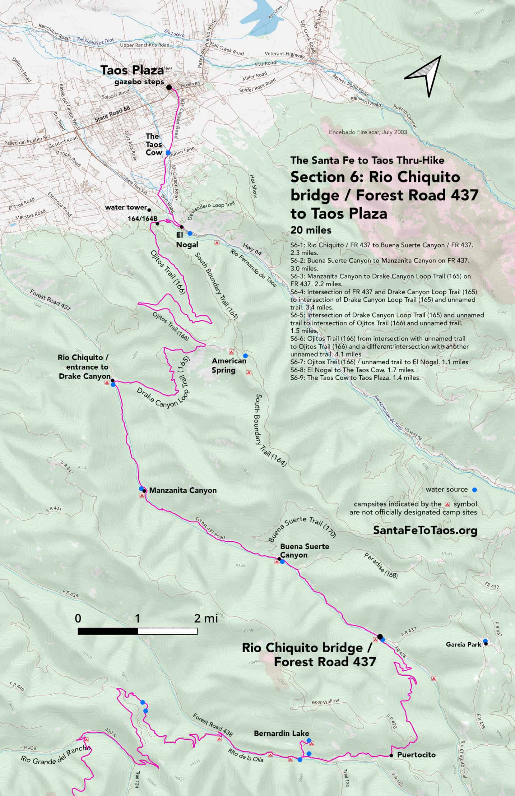
If you click on that map, it will open on a new page so you can zoom in to parts of it. It is also available for download and printing in legal size (8.5″ x 14″, 17MB) and in tabloid size (11″ x 17″, 14MB). Note that the campsites shown on the map above are not official campsites. But they are good places to put up a tent.


 of Section 6 of the Plaza to Plaza Thru-Hike")
Text overview of Section 6
S6-1: Rio Chiquito / FR 437 to Bueno Suerte Canyon / FR 437. 2.3 miles.
- The section starts at the bridge that crosses Rio Chiquito, at the approximate intersection of Forest Road 478 and Forest Road 437.
- You’ll be able to see FR 437 from the Rio Chiquito bridge. You can just walk straight up the slope to it, but it’s easier to take the road that crosses the bridge, turns left, passes a nice campsite, and then merges into FR 437.
- You will be walking west from here, on FR 437 for the rest of this subsection, and for another 7.3 miles. You will be next to Rio Chiquito the entire way.
- Forest Road 437 gets some traffic, but it’s “traffic” as in a car going by maybe every 20 minutes or so, even on a weekend in the summer. There is a very wide shoulder for most of the distance – a whole field’s worth of shoulder – and the road doesn’t have any tight bends until you get close to Drake Canyon.

- There are over a dozen established campsites along your route, all on the river side of the road. There are easily another 20 or more spots where you could put a tent along the way. Even if you skip the campsites and camp in the far corner of a field, or on the other side of Rio Chiquito, there’s no lack of space here.
- This area can feel a bit dry after being in the canopied coolness of FR 438 and earlier sections. The big fields are nice, though. By the time you’ve reached Paradise Canyon, just short of Buena Suerte Canyon, the trees will start getting closer to the road and you’ll have more shade. For the rest of the way on FR 437 you’ll be among big trees. It gets lush. I wonder how much of the lushness that starts in this area has to do with the beaver dams.
- When you have walked down FR 437 2.1 miles, you will have reached Buena Suerte Canyon. This is the end of Section 6-1.
S6-2: Buena Suerte Canyon to Manzanita Canyon on FR 437. 3.0 miles.
- From Buena Suerte Canyon, walk west on FR 437 for another 3.0 miles. Notice the beaver dams along the way. Remember how small Rio Chiquito was when you walked over the bridge? The beavers took that water and made football fields worth of bog from it. They do an amazing job at helping the land hold water.
- After 3.0 miles you will have reached Manzanita Canyon. This is the end of Section 6-2.
S6-3: Manzanita Canyon to Drake Canyon Loop Trail (165) on FR 437. 2.2 miles.
- Keep walking west on FR 437 for 2.2 miles.
- After 2.2 miles, there will be a track on your right going off into the hills at a 90-degree angle. This is Drake Canyon Loop trail (165). The intersection of FR 437 and Drake Canyon Loop Trail is the end of Section 6-3.
- Before you jump into the next section, get water. It’s only a couple hundred feet away. This is the last reliable water source you’ll have until you get to El Nogal trailhead, 10 miles away, and it’s a real good idea to carry enough water to get yourself all the way to the Taos Cow, which is 11.6 miles away. So go fill up on water.
- You may also want to camp near this water spot. I’ve camped on the far side of Rio Chiquito approximately across from the entrance to Drake Canyon. The “Rio” is small enough there to cross in good hiking boots and not get your socks wet. This far west along FS 437 you will hear and see more RVers and people, but if you’re on the far side of the creek you can get away from them.
S6-4: Intersection of FR 437 and Drake Canyon Loop Trail (165) to intersection of Drake Canyon Loop Trail (165) and unnamed trail. 3.4 miles.
- The entrance to Drake Canyon is wide and well-worn. You will be walking in on a forest track and going into the woods. There will be shade fairly soon. You’ll be under tall trees interspersed with shorter shrubby oaks and deciduous trees, with a few small fields here and there.
- After about 1.2 miles the trail will start to climb and bend left gradually (so heading north then northwest). It will continue to climb up a rocky forest track, heading northwest. As you get higher, the trees thin out a bit and shift into scrub and ponderosa pines.
- About 1.2 miles after that gradual bend left the trail will take a 90 degree right turn and continue to climb.
- 0.9 miles after that right, you’ll come upon a split in the trail. The left is still Drake Canyon Loop Trail (165), and this is where you’ll be headed. The right is an unnamed trail.
- Note that if you are absolutely parched for water, there is probably some 0.97 miles on South Boundary Trail. The water is at American Spring. It’s sketchy. American Spring is kind of a metal tube that’s serving as a holding tank next to a large seep. But if you really needed water, it’s there. Also, if you wanted to camp somewhere before you headed into Taos, there are plenty of large flat areas and fields around American Spring (also called “Bear Spring”). Note that many hiking maps show American Spring/Bear Spring in the wrong place. It’s on South Boundary Trail. You’ll know you’ve found it when you get to a muddy curve in the trail.
S6-5 Intersection of Drake Canyon Loop Trail and unnamed trail to intersection of Ojitos Trail (166) and unnamed trail. 1.5 miles.
- Staying on Drake Canyon Loop Trail (165), walking west, you’ll come up on Ojitos Trail (166) 0.5 miles later.
- Take Ojitos Trail (166), heading west, for another mile. You’ll be in shade under very large trees, on a wide forest track. There will be views to the north and your right side. In the second half of this one mile stretch the trail will begin to go down. It will be going down pretty much the rest of the way, all the way into El Nogal.
- Having been on Ojitos Trail (166) for one mile now, you’ll come to another trail split. Ojitos Trail (166) continues to the right – a very hard right – that will briefly be almost parallel to where you just walked. The left from this intersection is an unnamed trail that heads south. Don’t take it. Continue on Ojitos Trail (166).
S6-6 – Ojitos Trail (166) from intersection with unnamed trail to Ojitos Trail (166) and a different intersection with another unnamed trail. 4.1 miles.
- Continuing on Ojitos Trail (166), going around the tight bend right, you’ll now be going down and down on this same wide forest track, with the same big trees. Just now the view will be from your left.
- About 1.8 miles from the last trail split, the trail will do another tight bend left, then continue down for another 2.2 miles. There will be small bends here and there as you go, but there’s only one primary trail through here, and you’re on it.
- As you go down, it gets drier. By the time you’re a bit more than halfway down, the trees have gotten significantly smaller and the grasses have given way to bare rocky ground.
- After 2.2 miles, you’ll have been on a wide, dry, sun-exposed track for a while. You’ll have a good view of much of the south part of Taos. kKeep a keen eye out for a trail going off on your left, going up the slope from the track you’re on. This “unmaintained trail” will take you over to the intersection of 164 and 164B. Avoid the trail just before this left; if you are heading southeast after taking this trail, you’re on the wrong trail. Go out back to Ojitos and go just a wee bit further on it, like 200 feet.
- The turn-off for this little unnamed trail is the end of Section 6-6.
- If you miss that little trail, don’t worry. Ojitos Trail actually bends around, basically becoming parallel to the little shortcut you could have taken. Just stay on it and you will walk into “Ojitos Trail Connector”, Trail 164B. Take the right.
S6-7 Ojitos Trail (166) / unnamed trail to El Nogal. 1.1 miles.
- For those of you who did see the little shortcut trail, follow that, going mostly north, with nice views of the Taos mountains, for 0.3 miles. You will walk right into a little intersection of four trails going in different directions. You will also, suddenly, be on a fairly active trail; it’s likely you’ll see someone coming or going on the primary trail to your right even while you’re standing at the intersection.
- Standing facing east at the intersection of Trail 164, 164B, and the little unnamed trail you just came in on, you’ll see a trail marker. It is sometimes worn; you may not be able to read the trail numbers. Walk up to it and on to the clearly much more traveled trail, South Boundary Trail (164). Take the left, heading down and east.
- Note that South Boundary Trail (164) is one of the more heavily trafficked mountain bike trails around. Usually the people on bikes have slowed down by this point of the trail, but not always. If you’ve got a dog on a lead be careful. Also note that this trail can be a whiff tight in some spots, so if you’ve got a mountain biker coming down fast you will need to be aware of them. It’s not a great place to be wearing headphones.
- The good news is that South Boundary Trail (164) is lovely. It’s dry but shaded, and has quite a few people on it, but it’s pretty, and it’s headed down the whole way.
- From that trail intersection you are a mere 0.8 miles from El Nogal trailhead and parking lot. The trail on the way down does have a couple of offshoots; stay on the main trail.
- You’ll walk down to find a little creek on your left, by which time you’ll be on flat ground under large willows and cottonwoods. You’ll probably be able to see the parking lot in short order. You’ll also see the big wooden bent bridge that crosses the creek, Rio Fernando de Taos. Beyond that is the parking lot of El Nogal.
- Most unfortunately, I do not recommend that you drink even treated water at El Nogal (i.e., out of Rio Fernando de Taos). It has exceptionally high counts of e coli do to the trailhead area of El Nogal being basically a dog park, and the dog owners not picking up after their dogs. If you are in need of water, so much so that you can’t wait to get to the Taos Cow, walk east on the trail that parallels the El Nogal parking lot, walking along Rio Fernando de Taos. When you are far enough “up creek” to have gotten past most of the dogs, get your water there. Treat it twice. Also note that if it is really dry, Rio Fernando de Taos may not be much more than a mud puddle. I’ve only seen it like that once, but it was, of course, when I needed water.
- El Nogal marks the end of section 6-7.
S6-8 El Nogal to The Taos Cow. 1.7 miles.
- From El Nogal parking lot, head out toward the road, Route 64. Take a left on to Route 64, staying on the left side of the road.
- You’ll be on Route 64 for 0.3 miles. I hate taking you through here, and there is an alternate way to go if you are terrified of traffic or just feel up for th challenge of picking your way through somewhat of a no man’s land to avoid being on the road.
- Route 64 has a decent shoulder most of the way, but it’s not ideal for walking. The traffic comes through pretty fast, and there are large trucks and RVs sometimes.
- 0.3 miles down Route 64, take a left on to Route 585. Do not go straight on Kit Carson Road. Take the left instead. You’ll be on Route 585 for about 200 feet, then you’ll take a right on to the much quieter Witt Road.
- Follow Witt Road for 0.4 miles, then follow it further when it bends right at the intersection of Vista del Canon. If you have a dog with you, keep it leashed for the first quarter mile or so. There is a very unfriendly dog on the right side of the road just as you get on to Witt Road.
- From here, for 0.9 miles, you’ll be on Witt Road, walking through neighborhoods and fenced fields and the occasional bed and breakfast or a church. It’s mostly shaded, and while traffic does go through here, it goes slowly. People who live here walk this road a lot; you may encounter a loose friendly dog, or a dog that barks at you.
- At 0.9 miles you will see the Taos Cow on your left. The Taos Cow is the end point for Section 6-6. They have water, a bathroom, excellent food, and exceptionally tasty ice cream. They are open 7:30 am to 5pm seven days a week.
S6-9: The Taos Cow to Taos Plaza. 1.4 miles.
- Having perhaps gotten some food from the Taos Cow, go out to Witt Road and walk toward the big road on your left, which is Kit Carson Road, aka Route 64.
- Take a left at Kit Carson Road, walking basically north/northwest, for 1.36 miles, all the way into Taos Plaza. You’ll start seeing hotels and gift shops and whatnot as you approach Taos Plaza. Once you’re at Taos Plaza you’ll be within a couple minutes’ walk or less of several dozen restaurants, bars, hotels, motels, gift shops, ice cream shops, etc. Taos is fun. 0.55 miles down Route 64 from the Plaza is El Pueblo Lodge. I have stayed there many times, including after Riley and I finished the thru-hike in 2018.
- Walk into Taos Plaza, past the Veteran’s Memorial, and over to the steps of the gazebo. These steps mark the conclusion of your trek.
- Congratulations. You have completed the Santa Fe to Taos Thru-Hike.

Alt route: Intersection of 164 and 164B to Witt Road (avoiding Route 64 and El Nogal)
I loathe having people walking on Route 64. So I have tried to find a way around that. After scouting about seven different alternate routes, at least now I know I’ve found the best one. Maybe not a great alternative, but the best alternative. Here it is:
From the intersection of South Boundary (164), Ojitos Connector (164B) and the little unnamed cut through, look west, away from the trail marker at the intersection. Head west, down Ojitos Connector (164B). The trail slopes down; you’ll have a big view of Taos in front of you. You may be able to see the water tower a bit to the left of the trail in the distance as you walk.
Go 0.1 mile and look for a trail branching off to the right. You’ll have veered a bit right as you walked the 0.1 mile, too. Take this right branch.
You’ll walk another 0.1 miles, mostly north, on wide dry track. You’ll be in full sun, surrounded by dry junipers. There may be a lot of broken glass along the way. You may also notice quite a lot of animal tracks. The animals use this as a corridor (which is part of why all the broken glass is such a bad thing).
0.1 mile on, the trail will split in front of you. Go right, walking down for another 0.1 miles and then continuing on the faint path as the trail bends left, toward highway 585. You’ll be heading north for about 300 feet that includes this bend. You’ll be getting very close to the road, then the trail will bend more tightly left at the very last bit. Scramble over the dune/berm that’s between you and the road, and you’ll come down on to the shoulder of Route 585. Turn right, heading east, walking along the shoulder of 585 for about 0.2 miles until Witt Road is on your left, across the highway. Cross Route 585 and continue on Witt Road and the “official”/standard route of the thru-hike.
