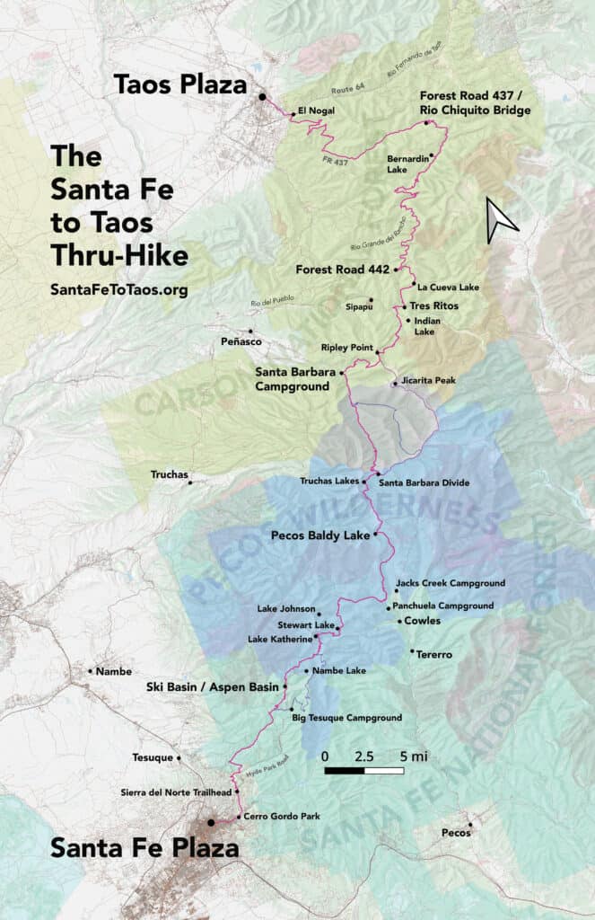
Route
Last updated 2/18/25. The Santa Fe to Taos Thru-Hike crosses the Santa Fe National Forest, the Pecos Wilderness, and the Carson National Forest. There are six sections, each roughly 20 miles:
Section 1: Santa Fe Plaza to Santa Fe Ski Basin (20.3 miles)
- S1-1: Santa Fe Plaza to Patrick Smith Park. 1.4 miles.
- S1-2: Patrick Smith Park to Arroyo Polay Trailhead via Cerro Gordo Park. 1.3 miles.
- S1-3: Arroyo Polay Trailhead to Sierra del Norte Trailhead. 1.8 miles.
- S1-4: Sierra del Norte Trailhead to Little Tesuque Creek / Juan Trail (Trail 399). 3.6 miles.
- S1-5: Little Tesuque Creek / Juan Trail (399) to Winsor Trail (254). 1.9 miles.
- S1-6: Winsor Trail (254) / Juan Trail (399) intersection to Winsor Trail (254) / Chamisa Trail (183) intersection. 3.3 miles.
- S1-7: Winsor Trail (254) / Chamisa Trail (183) intersection to Winsor Trail (254) / Borrego Trail (150) intersection. 1.9 miles.
- S1-8: Winsor Trail (254) / Borrego Trail (150) intersection to Forest Road 102. 2.0 miles.
- S1-9: Forest Road 102 to Winsor Trailhead at The Ski Basin. 3.1 miles.
- Alt route: Lake Peak alternate route. 9.5 miles.
- Alt route: Spirit Lake instead of Lake Katherine
Section 2: Santa Fe Ski Basin to Pecos Baldy Lake (26.4 miles)
- S2-1: Ski Basin / Winsor trailhead to “the Y”. 2.4 miles.
- S2-2: “The Y” to Puerto Nambe. 2.2 miles.
- S2-3: Puerto Nambe to Lake Katherine. 2.8 miles.
- S2-4: Lake Katherine to Winsor Ridge (271) / Skyline Trail (251) intersection. 3.6 miles.
- S2-5 Winsor Ridge (271) / Skyline Trail (251) intersection to Skyline Trail (251) / Cave Creek (288) intersection. 2.9 miles.
- S2-6: Cave Creek (288) / Skyline Trail (251) intersection to Cave Creek (288) Dockweiler Trail (259) intersection. 3.3 miles.
- S2-7 Dockweiler Trail (259) / Cave Creek Trail (288) intersection to Dockweiler field and rill. 4.1 miles.
- S2-8: Dockweiler field and rill to intersection of Dockweiler (259) and Jack’s Creek Trail (257). 2.5 miles.
- S2-9: Intersection of Dockweiler Trail (259) / Jack’s Creek Trail (257) to Pecos Baldy Lake. 2.6 miles.
- Alt route: Puerto Nambe to Spirit Lake to Winsor Creek.
Section 3: Pecos Baldy Lake to Santa Barbara Campground (19.8 miles)
- S3-1: Pecos Baldy Lake to Intersection of Skyline (251) and Jose Vigil Trail (351). 2.8 miles.
- S3-2: Intersection of Skyline (251) and Jose Vigil Trail (351) to Truchas Lakes. 2.5 miles.
- S3-3: Truchas Lakes to Santa Barbara Divide. 2.4 miles.
- S3-4: Santa Barbara Divide to West Fork of Rio Santa Barbara. 5.4 miles.
- S3-5: West Fork Rio Santa Barbara to intersection of Middle Fork Trail (24) and West Fork Trail (25). 3.6 miles.
- S3-6: Intersection of Middle Fork Trail (24) and West Fork Trail (25) to Santa Barbara Campground free parking lot. 3.1 miles.
- Alternative route: Middle Fork Trail
- Alternative route: Jicarita Peak
Section 4: Santa Barbara Campground to FR 442 (18.6 miles)
- S4-1 Santa Barbara Campground free parking lot to intersection Indian Creek Trail (27) and Bear Mountain Trail (28). 2.1 miles.
- S4-2: Intersection of Indian Creek Trail(27) and Bear Mountain Trail (28) to intersection Indian Creek Trail (27) and Divide Trail (36). 2.6 miles.
- S4-3: Intersection Indian Creek Trail (27) and Divide Trail (36) to Los Esteros. 1.5 miles.
- S4-4: Los Esteros to intersection of Agua Piedra Creek, Trail 19A and Trail 22. 3.8 miles.
- S4-5: Trail 19a/22/Agua Piedra Creek to Agua Piedra Campground entrance. 1.9 miles.
- S4-6: Agua Piedra Campground bridge/entrance to La Cueva Canyon / Trail 492. 0.9 miles.
- S4-7: La Cueva Canyon / La Cueva Trail (492) to intersection of La Cueva Trail (492) and Ojitos Maes Trail (182). 1.7 miles.
- S4-8: Intersection of La Cueva Trail (492) and Ojitos Maes Trail (182) to intersection of Ojitos Maes Trail (182) andLa Cueva 8. 1.4 miles.
- S4-9: Intersection of La Cueva 8 and Ojitos Maes Trail (182) to Forest Road 442. 2.7 miles.
Section 5: FR 442 to Rio Chiquito / FR 437 (26.1 miles)
- S5-1: FR 442 to the beginning of the burn. 4.7 miles.
- S5-2: Beginning of the burn on FR 442 to FR 439 / Rio Grande del Rancho. 4.2 miles.
- S5-3: FR 439 / Rio Grande del Rancho to the beginning of the Connector. 4.0 miles.
- S5-4: The beginning of the Connector to FR 438. 4.0 miles.
- S5-5: FR 438 / end of the Connector to Bernardin Lake. 2.4 miles.
- S5-6: Bernardin Lake to Puertocito (intersection of FR 438 and FR 478). 2.3 miles.
- S5-7: Puertocito to Rio Chiquito / Forest Road 437. 4.5 miles.
- S5 alternate. End of Trail 442 to FR 438 via unnamed ponds, Trail 124, and Palociento Creek. 13 miles.
Section 6: Rio Chiquito / FR 437 to Taos Plaza (20.8 miles)
- S6-1: Rio Chiquito / FR 437 to Buena Suerte Canyon / FR 437. 2.3 miles.
- S6-2: Buena Suerte Canyon to Manzanita Canyon on FR 437. 3.1 miles.
- S6-3 Manzanita Canyon to Drake Canyon Loop Trail (165) on FR 437. 2.2 miles.
- S6-4: Intersection of FR 437 and Drake Canyon Loop Trail (165) to intersection of Drake Canyon Loop Trail (165) and unnamed trail. 3.4 miles.
- S6-5 Intersection of Drake Canyon Loop Trail and unnamed trail to intersection of Ojitos Trail (166) and unnamed trail. 1.5 miles.
- S6-6 Ojitos Trail (166) from intersection with unnamed trail to Ojitos Trail (166) and a different intersection with another unnamed trail. 4.1 miles.
- S6-7 Ojitos Trail (166) / unnamed trail to El Nogal. 1.1 miles.
- S6-8 El Nogal to The Taos Cow. 1.7 miles.
- S6-9 The Taos Cow to Taos Plaza. 1.4 miles
- Alt route: Intersection of 164 and 164B to Witt Road (avoiding Route 64 and El Nogal)