
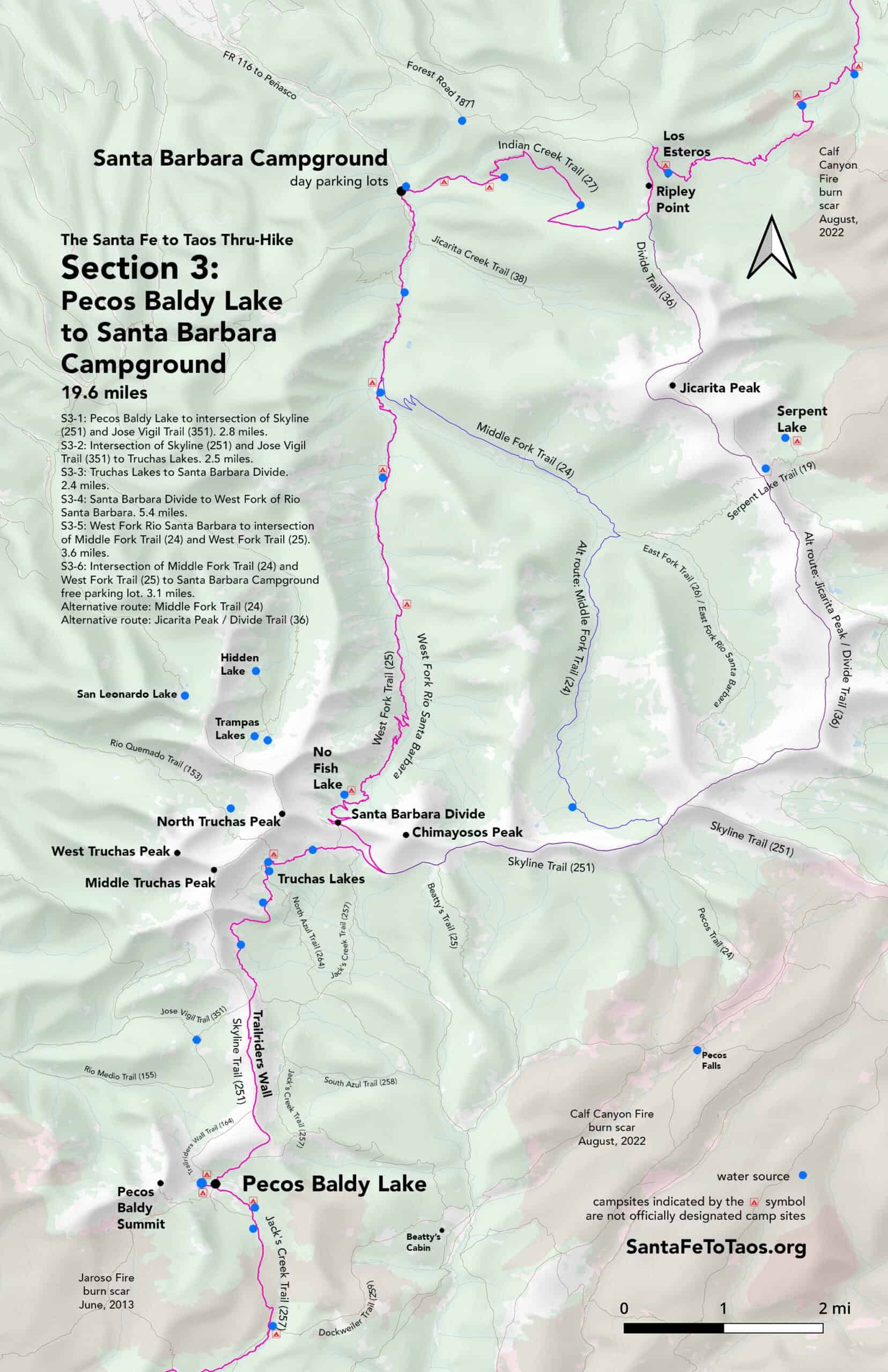
Section 3: Pecos Baldy Lake to Santa Barbara Campground
- S3-1: Pecos Baldy Lake to Intersection of Skyline (251) and Jose Vigil Trail (351). 2.8 miles.
- S3-2: Intersection of Skyline (251) and Jose Vigil Trail (351) to Truchas Lakes. 2.5 miles.
- S3-3: Truchas Lakes to Santa Barbara Divide. 2.4 miles.
- S3-4: Santa Barbara Divide to West Fork of Rio Santa Barbara. 5.4 miles.
- S3-5: West Fork Rio Santa Barbara to intersection of Middle Fork Trail (24) and West Fork Trail (25). 3.6 miles.
- S3-6: Intersection of Middle Fork Trail (24) and West Fork Trail (25) to Santa Barbara Campground free parking lot. 3.1 miles.
- Alternative route: Middle Fork Trail
- Alternative route: Jicarita Peak
19.8 miles total Section 3
If you click on that map it will open in a new page so you can zoom in to specific parts of it. You can also download this map for printing. It’s available in legal size (8.5″ x 14″, 14 MB) and in tabloid size (11″ x 17″, 12 MB). Note that the campsites shown on the map above are not official campsites. They’re just good spots for dispersed camping.


Overview of Section 3
S3-1: Pecos Baldy Lake to Intersection of Skyline (251) and Jose Vigil Trail (351). 2.8 miles.
- Section 3 starts at the trail sign that marks the intersection of Skyline Trail (251) and Jack’s Creek Trail (257). From the trail sign, head north / northeast up what is both Skyline Trail and Jack’s Creek trail.
- You will be heading into evergreen forest with small trees and lots of grassy areas. The trail will climb gradually.
- At 0.6 miles from the Jack’s Creek / Skyline Trail sign you left from at Pecos Baldy Lake, Jack’s Creek Trail will split off to the right. Stay left, on Skyline trail as the trail continues to climb. The views will begin to open up a lot.
- Within the next 0.3 miles you will be able to see the Trailriders Wall, all the way to Truchas Peaks. It’s a fantastic view. Just pay attention as the trail makes a hard left turn at one point. There is an extremely steep slope on the right side of the trail, and the slope drops off within feet of the trail.
- Continue on (there are no more spots that tight) and follow the path up to the top of the Trailriders Wall. You may notice another trail coming in from the left and merging with Skyline Trail. This incoming trail is Trailriders Wall Trail (164). Trailriders Wall Trail ends right here where it connects with Skyline Trail (251). Keep going north on Skyline Trail.
- For the next 1.4 miles you will have a glorious 360-degree view. Consider taking a rest anywhere along the trail to take in whatever particular view you like best. The Trailriders Wall is probably most accurately described as a long narrow mesa, or, even more accurately, as a “hogback“. There is a little grove of trees about 0.3 miles from the junction with the Trailriders Wall Trail (164). If you wanted shade or quick cover from a thunderstorm, that would be a good spot.
- The trail climbs gradually up then gradually down, then has one switchback to accomodate a steeper down as you come off the Trailriders Wall. You’ll see the sign for the intersection of Jose Vigil Trail (351) and Skyline Trail quite a bit before you get to it; it’s all very open with short groundcover around here. The trails are well-worn over the Trailriders Wall, too, so don’t worry about losing the trail. There are also a series of 5-foot high rock cairns, so you’ll be able to see where the trail is headed from quite a way off, or if you’re dealing with snow cover. Note that it is not impossible for it to snow in August in this area. It just doesn’t happen nearly as much as it used to.
- The trail sign marking the junction of Skyline Trail (251) and Jose Vigil Trail (351) is the end of Section 3-1.
- Alternate route: You could take Trailriders Wall Trail (164) up from the north slope of the Pecos Baldy Lake basin, but as it’s not a primary trail I like to keep things simple and use Skyline Trail from Pecos Baldy Lake for the thru-hike route.
- Alternate route: If you’re worried about lightning or weather as you go over the Trailriders Wall, Jack’s Creek Trail (257) is a good alternative. It runs approximately parallel to the Trailriders Wall and Skyline Trail until it reaches South Azul Trail (258) 2.6 miles later. There is water along this trail as well. Note that if you do take Jack’s Creek Trail, from the split at Skyline and Jack’s Creek Trail you will also pass Sebadillosos Trail (245) on your right 0.7 miles from the split. Then you will pass another trail on your right, South Azul Trail (258), 1.9 miles from the split. You will be on both Jack’s Creek Trail (257) and South Azul trail for the next 0.7 miles as you head north, where Jack’s Creek Trail will go right and South Azul will go left. To rejoin the route of the thru-hike, take the left on South Azul. You will join up with Skyline Trail and the thru-hike 0.7 miles from your left on to South Azul Trail (258). Also note, of course, that the official route of the thru-hike stays on Skyline Trail (251) and goes over the Trailriders Wall.

S3-2: Intersection of Skyline (251) and Jose Vigil Trail (351) to Truchas Lakes. 2.5 miles.
- From the trail sign marking the junction of Skyline Trail (251) and Jose Vigil Trail (351), follow Skyline Trail north/northeast and down the slope.
- 0.2 miles from the trail sign, South Azul Trail (258) will come in from the right. Stay north/straight on Skyline Trail.
- 0.1 miles later you’ll also pass Rito Azul trail on the right. There is water about 500 feet down this trail, but unless you’re in urgent need, continue on, north, along Skyline. You’ll be at a water source right on Skyline Trail soon.
- For the next 0.8 miles the trail will climb (400 ft total) as you go through evergreen forest along rocky trail. There are some nice views behind you of the TrailRiders Wall, and some stunning views on your left of the cliff faces that make up the southern part of Truchas Peak. There is also significant bark beetle damage in this area, unfortunately. When I went through in 2018, before the bark beetles arrived, it almost had an Eden-like feel to it.
- Note that there are technically three Truchas Peaks. There is plain “Truchas Peak”, which is what you’ll be seeing on your left as you walk through this area. Then there is “Middle Truchas Peak” which is about one mile northwest of you at this point. Then there is “North Truchas Peak”, where you’re headed, that you’ll see rising up to the north of Truchas Lakes.
- The trail (Skyline Trail) will gradually bend to the left, below the south and east edge of those cliff faces. The steep slopes and sweeps of grass are beautiful. Look for or listen for marmots when you go through a stretch of large talus rocks. There are a few pools and ponds along this way, with a good water source about 500 feet after the trail levels off and bends right.
- There’s a large pond on the right about half a mile from that water source. All through here you’ll be going up and down a bit, through huge evergreens, with views to the south. Again, the bark beetle damage is evident, but half the trees are still okay. The next generation of smaller trees has begun sprouting up. The far views to the south and east show the damage from the 2022 Calf Canyon/Hermits Peak Fire.
- About 0.3 miles after the pond, North Azul Trail (264) will come in on the rightish, but almost in front of you. Stay on Skyline, which will feel like you’re taking a left.
- The next 0.2 miles is a climb up to lower Truchas Lake. You won’t see the lake until the very last moment, and then, for a moment, you’ll be practically eye-level with it as you climb up.
- There are better campsites on the far, north side of lower Truchas Lake, though there are a few spots on the south side. There is also Upper Truchas Lake, which has several camp sites.
- There are bighorn sheep about. The males can be aggressive, but only about protecting what they think is their space. Be very mindful if you have a loose dog. The sheep will win a match of sheep vs dog. The female sheep are far more docile, but they have become used to people feeding them, so they may get very close, and they may just outright beg for food. They will try to get into your tent, so make sure that’s zipped up. Do NOT feed them.
- There is a trail sign about the bighorn sheep, and marking the intersection of Skyline Trail (251) and Rio Quemado Trail (153) at the south-eastern corner of Lower Truchas Lake. This is the end marker for Section 3-2.

S3-3: Truchas Lakes to Santa Barbara Divide. 2.4 miles.
- The trail marker at the intersection of Skyline Trail (251) and Rio Quemado Trail (153) at the south-eastern corner of Lower Truchas Lake is the starting point for Section 3-3. Head east on Skyline Trail. You’ll be skirting the south side of some steep, impressive cliff faces on your left, and will be among huge evergreens. There are occasional views to the south, which, unfortunately, now show more bark beetle damage and the effects of the 2022 fire.
- As you continue on, the trees become sparser and smaller. There are more open fields. You’ll cross a few small, very shallow creeks, but they’re enough to get water from if you needed it.
- At 0.7 miles from the trail sign at Lower Truchas Lake, you should see a piled stone marker on the left side of the trail. It isn’t always there; snow melt knocks the stones over. This marker is for a shortcut that will take you up to the top of the Santa Barbara Divide. Some maps show this shortcut as “Trail 264”. I personally have not taken this trail, but two people I’ve spoken to have, and they both swear it’s fine trail. It has looked very faint every time I’ve gone by it, and – per my usual practice – I try to keep the route of the thru-hike on primary, established trails wherever possible. But this shortcut exists, and some people really like it. If you do take it, you will miss the fan-tas-tic views going up Skyline and over on Beatty’s Trail, but it’s not like those are the only views around.
- If you skip the shortcut you’ll continue on Skyline heading east. After another 0.2 miles you’ll see another trail coming up from the left. This is our old friend Jack’s Creek Trail (257). Stay on Skyline Trail, which will briefly take you southeast as it bends around Chimayosos Mountain. The trail also starts to climb here. It’s not a killer climb, but given the altitude you’re at – 11,800 feet – you may get tired a little faster than usual.
- Another trail will come in on your left at a very sharp angle. This is Beatty’s Trail (257). Take it and continue on, now heading in a northwesterly direction.
- You’ll be on Beatty’s Trail for another 0.8 miles before you reach the top of the Santa Barbara Divide. The trail is a little dicey. It’s on packed gravel, fortunately, but it’s also on a rather steep slope. Even the trail itself slopes for some of the way. You might want to have your poles out to steady yourself if you have issues with heights. You might also want your poles out because the views from this trail are so amazing that it’s really easy to just look and look and look and forget where your feet are once or twice. There is some tree cover, but ideally you should approach and go over the Divide in good weather.
- As you reach the top of the Santa Barbara Divide, enjoy the nearly 360-degree views. Look for that shortcut trail coming up from the south side. Have someone take a photo of you standing next to the trail sign. That trail sign is the end marker for Section 3-3.

S3-4: Santa Barbara Divide to West Fork of Rio Santa Barbara. 5.4 miles.
- From the trail sign at the top of the Santa Barbara Divide, follow Trail 25 down a series of switchbacks.
- Note that Trail 25 is named “Beatty’s Trail” on the south side of the Santa Barbara Divide, and West Fork Trail on the north side of the Divide.
- The switchbacks are very well worn, and the trail down is obvious. It’s just steep. Very steep. If you have issues with heights, get your poles out to steady yourself. I have concerns that if someone fell with any kind of momentum on these switchbacks, they might keep falling, and it is a very, very long way down, all on talus gravel. The good thing is that the gravel on the trail is well packed. Just maybe have a good drink of water with electrolytes before you head down, and consider having a little rest before, and don’t rush.
- You will go in and out of forest on the way down the switchbacks. They level out, and the slope levels out after that. Almost exactly one mile from the trail sign at the top of the Santa Barbara Divide, you may notice a large pond (or a “lake” in New Mexico scale) off the left side of the trail and where you make a hard turn right. This is No Fish Lake. It’s at the bottom of a somewhat steep slope, but nothing like the north side of the Divide. There is also a little campsite a bit down and to the right. This would be an excellent place to camp for the night if you were southbound and it was just a little too late or the weather was a little too intense to go over the Divide.
- From No Fish Lake you will go down and down West Fork Trail (25). You’ll be in evergreen forest with huge trees.
- There is water on the way down. First, 0.4 miles from No Fish Lake, and then again 0.7 miles from No Fish Lake. And then again 1.7 miles after that, and then again 0.3 miles after that. The next water after that is the West Fork of Rio Santa Barbara, 1.0 miles further along the trail.
- The trail down has tricky footing in some places where there is white crushed stone all along the slope and making the up trail. The trees have taken a beating in patches on this subsection, too, particularly between No Fish Lake and the first and second water sources after No Fish Lake. There is a fair amount of blowdown, so expect to be swinging your legs over some high logs. It gets better after a mile or so.
- After the very long down, and after hearing the West Fork of Rio Santa Barbara for much of the way down (it is usually less than 500 feet from the trail the whole way) you will finally turn right and be looking directly at it. It’s a good 14 feet wide, but not deep enough to get good boots wet inside.
- After you’ve crossed, you will have completed Section 3-5.
S3-5: West Fork Rio Santa Barbara to intersection of Middle Fork Trail (24) and West Fork Trail (25). 3.6 miles.
- Having crossed Rio Santa Barbara, you can now enjoy a long walk through a very long field. For the next 1.5 miles the trail goes straight, through a huge, generally flat field. Rio Santa Barbara will be on your left, usually about 150 feet away.
- There are ample campsites on the left and along the river the whole way. There are also cows.
- After about 1.5 miles you will go back into mixed evergreen and aspen forest. The trail stays mostly flat with some very easy slopes. You may run into one or two people at most.
- About 1.6 miles into the forest you will cross the Middle Fork of Rio Santa Barbara. The crossing has a cool V-shaped bridge. There’s a nice campsite on the west side of the bridge.
- 0.2 miles after the bridge you’ll see the sign for Middle Fork Trail (24) coming in from the right. This trail sign marks the end of Section 3-5.
S3-6: Intersection of Middle Fork Trail (24) and West Fork Trail (25) to Santa Barbara Campground free parking lot. 3.1 miles.
- Your long walk towards Santa Barbara Campground continues. This is all good, wide trail. There’s little blowdown. Most of the trees look healthy.
- Rio Santa Barbara will be nearby the whole way, rarely more than 200 feet from the trail. You’ll be going through patches of nice big grassy fields, with campsites sprinkled along the way next to the river.
- As you get closer to Santa Barbara Campground, the hills on either side gradually get higher and higher, rockier and rockier. Eventually, you’re in a full-on canyon, with nearly vertical rock cliffs on either side, and Rio Santa Barbara crashing down through the middle of it.
- There is another bridge – wooden, wide, and in excellent shape – 0.7 miles after the first bridge (the one in the last subsection, S3-5). Once you cross that second bridge it’s 1.4 miles to the south edge of Santa Barbara Campground.
- As you get closer to the campground, like around the second bridge, you’ll probably start to see more people. There’s good fishing in Rio Santa Barbara, so a lot of fly fishermen (and women) like to walk up the trail to get to the quieter spots.
- You may even notice the “Chili Waters” fishing sign as you get closer to Santa Barbara Campground. It’s just a little before Centennial Trail (100), which goes off to the left. Also note the sign marking the edge of the Pecos Wilderness. From this point north, you are in Carson National Forest.
- When you pass Centennial Trail you are 0.8 miles from the far edge of Santa Barbara Campground. You may also notice a little side trail that splits off from the main trail (Middle Fork Trail 24) to the right, about 0.3 miles from Centennial. This runs parallel to Middle Fork Trail, then veers left to rejoin it just before the gate at the edge of Santa Barbara Campground. It’s a good idea to just stay on the main trail. You may also notice yet another trail that branches off to the left about 26 feet before you go through the gate/fence into the Santa Barbara campground. This is Jicarita Creek Trail (38). Don’t take it. Just go through the gate into Santa Barbara, and walk on either side of the loop road over to the free parking lots.
- If you’ve parked in the free parking lots at Santa Barbara Campground, on the north side of the campground, you’ll walk another half mile through the long skinny loop road of campsites. There is a campground host who lives at the campground to manage the sites. If you need information or help, look for their big RV right near the cattle guard, just north of the loop of the camping grounds road. There are public toilets and a potable water source within sight of that cattle guard, too.
- Maybe sit down in the grassy area by Rio Santa Barbara that’s next to the first parking “lot” (it’s about four spaces) and appreciate how far you’ve come. You have completed Section 3 of the thru-hike. You are halfway to Taos.

Alternate route: Middle Fork Trail instead of the Santa Barbara Divide
- From near the south side of the Santa Barbara Divide, at the trail split of Beatty’s Trail (25) and Skyline Trail (251), instead of taking Beatty’s Trail left (as described in Section 3-3 earlier on this page), stay on Skyline Trail. As you go forward from here, you are briefly on both Beatty’s Trail (25) and Skyline Trail (251).
- In 0.6 miles the trails split. You will pass Beatty’s Trail (25) going off on your right. Stay on Skyline.
- In another 2.5 miles you will reach the intersection with Middle Fork Trail (24). It will will cross Skyline, heading north and down on your left from the ridgeline and south and down a steep slope on your right.
- Taking the left on to Middle Fork Trail, (heading north) will get you to Santa Barbara Campground. Most immediately, it will also get you to water; about 1.1 miles from this intersection you will cross the first major tributary of the Middle Fork branch of Rio Santa Barbara.
- If you wanted to continue towards Santa Barbara Campground, you could continue another 3.9 miles down, all on Middle Fork Trail, until you reached a trail split. The right of the split would be East Fork Trail (26). The left of the split would be Middle Fork Trail continued. Stay on Middle Fork Trail.
- Following that left and Middle Fork for another 3.9 miles, (and passing an unnamed trail on your left 0.8 miles from where you passed East Fork Trail) would bring you to West Fork Trail (25), with West Fork coming in from your left as you approach the split. You’d take the right, going north from this split, and would then be following the primary route of the thru-hike. Just staying north on Middle Fork Trail from this junction with West Fork Trail would bring you into the south end of the Santa Barbara Campground loop road about in about 2 miles.
- You will be within 500 feet of the Middle Fork of Rio Santa Barbara for pretty much the entire way, so there’s no need to worry about water.
- You will also be avoiding the dicey trail on the south side of the Santa Barbara Divide.
- This route is a little longer than the primary route of the thru-hike. It’s 12.1 miles from the Beatty / Skyline split all the way down to the West Fork / Middle Fork split if you take this alternate route. The distance from those same two points is 8.8 miles via the primary/”official” route of the thru-hike.
- Here’s the problem: I have not actually walked this route. So while it’s interesting, and it is absolutely there (several hundred+ social media photos and extensive map information and other hikers’ experiences confirm this), I personally have not walked this trail. I was dying to get out here before the snow fell this fall (of 2024), but work blocked me. So I will have to wait until spring 2025 to confirm this route and send photos.
- I do think it could be neat, though. But it’s only part of what could be basically a “grand tour” of peaks if you did the Jicarita Peak alt route.

Alternate route: Jicarita Peak instead of the Santa Barbara Divide
- From near the south side of the Santa Barbara Divide, at the trail split of Beatty’s Trail (25) and Skyline Trail (251), instead of taking Beatty’s Trail left (as described in Section 3-3 earlier on this page), stay on Skyline Trail. For the next little bit you’ll be on both Beatty’s Trail and Skyline Trail.
- In 0.6 miles the trails split. Beatty’s Trail (25) will go off on your right. Stay on Skyline.
- In another 2.5 miles you will reach the intersection with Middle Fork Trail (24). It will will cross Skyline, heading north and down on your left from the ridgeline and south and down a steep slope on your right. Stay on Skyline Trail.
- 0.4 miles later you will come up on another trail on your right. This is Skyline Trail, where it veers off to the east and then eventually bends down to the south. Skyline continues all the way down to near Barillas Peak, which is about the same latitude as Las Vegas, NM (just for context).
- We are not going to Las Vegas, so we will say goodbye to Skyline Trail (251) and pick up Divide Trail (36). Note that Divide Trail is not The Continental Divide Trail; that trail is more than 30 miles east of this point. “Divide Trail” refers to the Santa Barbara Divide. Fun fact, though: The Continental Divide Trail does also go through Carson National Forest.
- Continue on Divide Trail (36) from where it splits from Skyline. 1.0 miles later, after being careful along ridgeline trail – where you are potentially exposed to high winds, hails, and lightning, and there’s an almost vertical drop-off on the right side of the trail – you will come up on East Fork Trail (26) on your left.
- If you wanted to, you could take this down and get to Santa Barbara Campground by a very similar route to the Alt Route via Middle Fork Trail (see above on this page). Note, also, if you needed water, you could just zip down East Fork Trail for 0.8 miles and get some water at the tributary to the East Fork branch of Rio Santa Barbara that crosses the trail. If you were feeling especially curious, you could follow that little tributary a mere 100 feet up and off trail (I know… off trail is risky…) to a nice little pond that about 80 feet wide and in a fairly flat area, at least per what the contour lines on the maps show. Might be a sweet spot. There’s another little pond, even closer to the trail just a few feet further along the trail. These ponds are so close to the trail you could possibly see them from the trail. I have not been to this little spot, but it’s on my short list of things to go see as soon as the snow melts in the higher elevations in 2025. So… hopefully in mid June. (You could do this same thing – zip off the ridgeline for water or a place to stay for the night – from Middle Fork Trail as well. In an odd coincidence, there’s water 1.2 miles from the ridgeline down Middle Fork Trail (24).)

- Assuming you do not need water, a place to sleep, or cover from weather, continue on Divide Trail (36) from East Fork Trail (26), heading east/northeast.
- The trail will move away from that interesting cliff on your right in about 500 feet. You will still be on ridgeline for the rest of the way, so hopefully you picked a day with good weather.
- As you continue over the ridgeline, the trail will shift from heading east to heading north. Right about where this gradual left bend is, you may see Middle Fork Lake on the right side of the ridgeline. In another 0.8 miles from this turn, you’ll be passing Trouble Mountain on your right. North Fork Lake will also pass by on your right in another half mile or so, followed by Horseshoe Lake on your right, about another 0.7 miles along the Divide Trail.
- 1.5 miles later you will reach the intersection of Divide Trail and Serpent Lake Trail (19). The Divide Trail continues straight ahead. If you need to get off the ridgeline or you need water, take the right down Serpent Lake Trail. There’s a pond 0.1 miles from the intersection with the Divide Trail. This is your last access to water for 6.0 miles, when you reach Los Esteros. Note that if you wanted to get to Santa Barbara Campground, you’d take the left from this intersection, heading west down the somewhat steep Serpent Lake Trail.
- 0.3 miles from the Divide / Serpent Lake intersection, the trail splits. The right branch will take you to the summit of a mountain that is *not* Jicarita Peak in 0.5 miles. The left branch is Divide Trail (36).
- From that split, it is another 0.9 miles to the split for the Jicarita Peak (12,808 feet). There is an unmaintained trail that goes down from the peak and re-joins the Divide Trail on the other side. If you don’t take the peak route, it’s 1.3 miles from the split to get around Jicarita Peak to the point where the peak route rejoins the Divide Trail. If you do take the peak route, it’s 0.8 miles point to point.
- Note that there is a little split in the Divide Trail in this same area where the peak route rejoins the Divide. It’s only 300 feet from the Divide Trail, and the unmaintained little “diversion” rejoins the Divide Trail in about 700 feet. Either trail will do.
- From where the little “diversion” rejoins the trail, you’ll start down. It’s a gradual down that is basically flat for a while. About one miles on you will go back below the tree line. Another mile after that you will walk up to where Indian Creek Trail (21) comes in on the left. This is also where you rejoin the primary route of the thru-hike.
- Note that this Jicarita alternate route does not take you into Santa Barbara Campground. If you need to get to Santa Barbara Campground but want to get in as much of this alt route as possible, go down via Serpent Lake Trail.
