
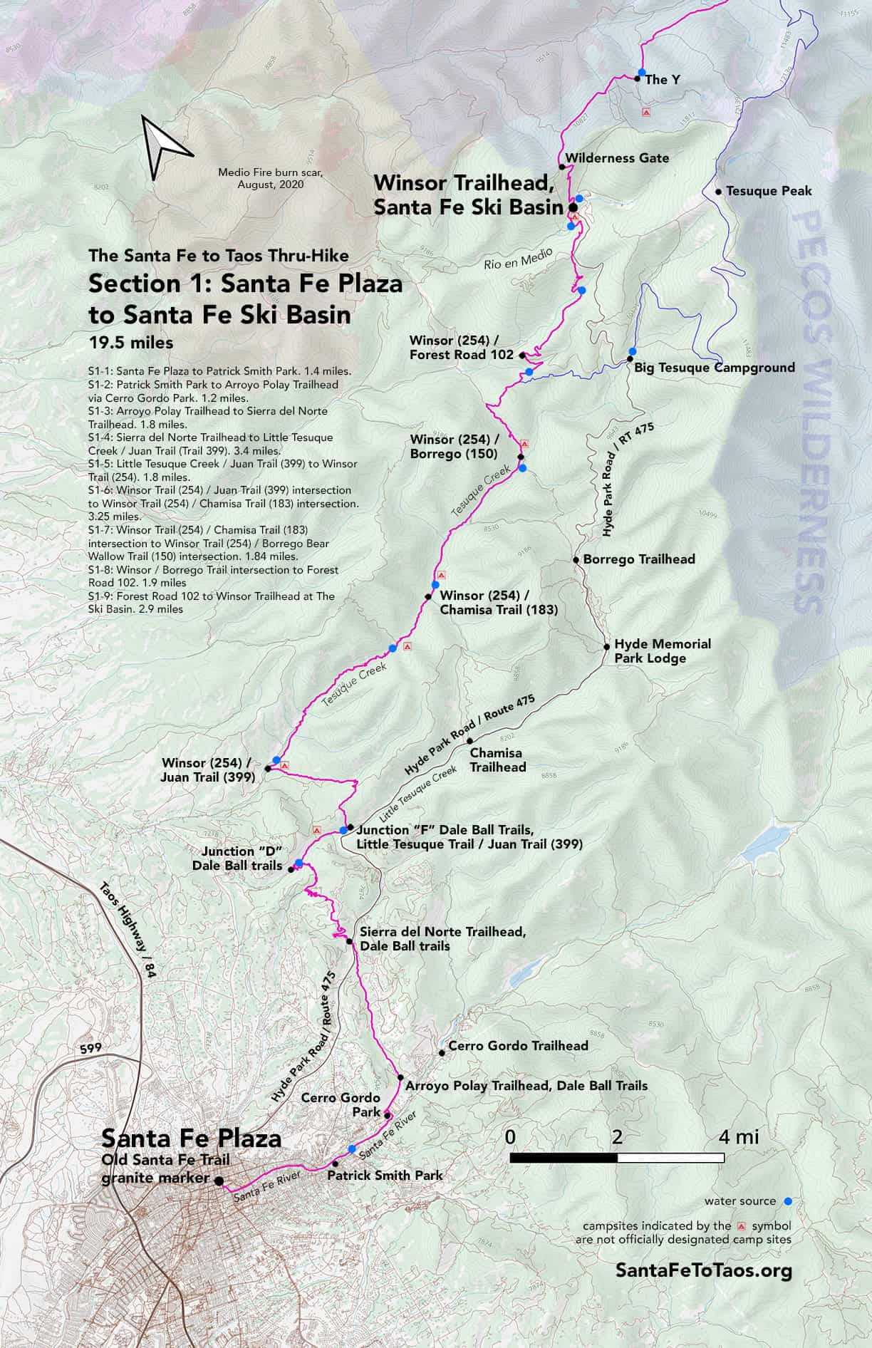
Section 1: Santa Fe Plaza to Santa Fe Ski Basin
- S1-1: Santa Fe Plaza to Patrick Smith Park. 1.4 miles.
- S1-2: Patrick Smith Park to Arroyo Polay Trailhead via Cerro Gordo Park. 1.3 miles.
- S1-3: Arroyo Polay Trailhead to Sierra del Norte Trailhead. 1.8 miles.
- S1-4: Sierra del Norte Trailhead to Little Tesuque Creek / Juan Trail (Trail 399). 3.6 miles.
- S1-5: Little Tesuque Creek / Juan Trail (399) to Winsor Trail (254). 1.9 miles.
- S1-6: Winsor Trail (254) / Juan Trail (399) intersection to Winsor Trail (254) / Chamisa Trail (183) intersection. 3.3 miles.
- S1-7: Winsor Trail (254) / Chamisa Trail (183) intersection to Winsor Trail (254) / Borrego Trail (150) intersection. 1.9 miles.
- S1-8: Winsor Trail (254) / Borrego Trail (150) intersection to Forest Road 102. 2.0 miles.
- S1-9: Forest Road 102 to Winsor Trailhead at The Ski Basin. 3.1 miles.
- Alt route: Lake Peak alternate route. 9.5 miles. Skips Winsor from Big Tesuque Trail up to the Ski Basin and all the way through to Puerto Nambe. Instead, you take a right off Winsor and go through Big Tesuque Campground, up Aspen Vista, and over Lake Peak, Deception Peak and Penitente Peak then down into Puerto Nambe to rejoin the standard route of the thru-hike.
20.3 miles total Section 1
You can download and print this map in legal size (8.5″ x 14″, 25 MB) and in tabloid size (11″ x 17″, 36 MB).


Section 1
Section 1-1: Santa Fe Plaza to Patrick Smith Park. 1.4 miles.
- Walk from the southeast corner of Santa Fe Plaza (from the granite end marker for The Santa Fe Trail) south along Old Santa Fe Trail. You’ll pass La Fonda hotel on your left.
- Continue on Old Santa Fe Trail, cross the intersection with Water Street, and continue along Old Santa Fe Trail. You’ll pass the Loretto Chapel (aka the Spiral Staircase) on your left.
- Walk towards East Alameda, cross the intersection, and take a left. You’ll be on Alameda, facing east. You should be able to see the Santa Fe hills in the distance.
- Walk along the sidewalk and through the Santa Fe River Park. The “river” will be on your right.
- Continue along Alameda for 1.4 miles crossing Paseo de Peralta, Delgado Street, and East Palace Avenue. There are several little bridges along the way, and you can walk along the opposite side of the river if you like. Consider crossing at the “Enchanted Small Falls”, about 600 feet after you’ve crossed Delgado Street. Just know that you’ll have to cross back to the other side of the Santa Fe River before you get to East Palace Avenue. There’s another little bridge you can cross at about 600 feet before you reach East Palace.
- Get back on the sidewalk along Alameda by the time you reach the intersection with East Palace. This would be a good place to cross the street, too, so you’re walking along Alameda on the north side / the side opposite the river.
- Next you’ll cross Gonzales Road on your left. Keep going another 750 feet or so and you’ll see the side road to go into Patrick Smith Park on your right.
- You have just completed Section 1-1.
Section 1-2: Patrick Smith Park to Arroyo Polay Trailhead via Cerro Gordo Park. 1.3 miles.
- To continue on Section 1-2, keep walking along Alameda on the side of the street opposite the river. Alameda will take a sharp right turn in about 300 feet after the entrance to Patrick Smith Park. You are not going to follow that turn. Instead, look for the dirt road and little intersection ahead and on your left.
- You’ll go slightly left but mostly straight at this little intersection, walking on to Camino Pequeno. On the right side of Camino Pequeno, just a few feet past the little intersection, you’ll probably notice the signs about the neighborhood, including the warnings from the local owners about no trespassing, keeping dogs on leashes, etc.
- Camino Pequeno, and the trail that runs along next to it, are public access, but please: Be super-respectful as you go through here. Keep your dog on a leash. Seriously consider NOT riding a bike through here. Be quiet, and friendly, and kind. Be the good hiker.
- If the Santa Fe River is not running high (like in spring during snowmelt, or after a big rainstorm during monsoon season), take the little path to the right in front of the sign with all the warnings. Then take an immediate left, and make your way up and along the river. You will probably have to cross the river in a couple of places. The trail splits into different paths along the river, and about one tenth of a mile along the river you’ll have to get back up on Camino Pequeno anyways. I suggest hugging the river just to give the houses along Camino Pequeno as much space and peace as possible. They are not thrilled with having foot traffic through here. You can also just walk along Camino Pequeno the whole way, and most people do.
- About a third of a mile from where you left Alameda, look for a path on the right off Camino Pequeno. It’s not marked, and the willows conceal it, but the ground is well-worn. When you look down the path, about 20 feet away you should be able to see the river and a very narrow, simple bridge that crosses the river here. It’s a bit of a tight squeeze (and another reason to not bring a bike through here, or a reactive dog). This is the first of many times you’ll cross the Santa Fe River in this little stretch of trail. You are now in the “corridor” along the Santa Fe River. Follow the trail (and the Gaia maps) for the next 0.4 miles or so.
- Around 0.4 miles, you’ll see the sign for the Upaya Nature Trail, along with the minimalistic fence that runs on either side of the gate to the trail. If you’re standing in front of this Nature Trail sign, turn around and look to your left. There’s a path that goes up a slope on the left from this point. Go up that slope. You’ll come out at the Adam Gabriel Armijo Community Garden, and will walk right past their enclosed garden on your left after you’ve gone up the slope.
- As you walk past the little enclosed garden, you’ll be walking into Cerro Gordo Park. There is a water fountain here, a parking lot, picnic tables, a nice big tree for shade, and a jungle gym. This is your last access to water for about the next two hours or so until you reach Little Tesuque Creek.
- Walk through the parking lot and follow the road out and as it makes a sharp turn to the left to reach Cerro Gordo Road. Take a hard right and walk along Cerro Gordo Road for 0.4 miles. Most of this length of road has decent shoulder, and people tend to drive slow (or slower) because this is a frequently-used road for walkers and joggers.
- After 0.4 miles along Cerro Gordo Road, you’ll see the trailhead and big turnaround at Arroyo Polay Trailhead of the Dale Ball Trails system on the left side of the road.
- You have completed Section 1-2 of the thru-hike.
Section 1-3: Arroyo Polay Trailhead to Sierra del Norte Trailhead. 1.8 miles.
- To continue on to Section 1-3, walk into the arroyo from the Arroyo Polay trailhead.
- Continue walking 0.84 miles north along the trail, through the arroyo. Along your way you will pass “Chasing Dreams”, an abandoned convertible facing upstream in the arroyo.
- After 0.84 miles you will reach marker 24 of the Dale Ball Trails. This marker includes a simple but useful map of the other trails and markers in the area. Keep walking forward/north on this trail.
- 0.24 miles after marker 24, you’ll come to a spot where the trail splits, and marker #20. Keep going straight (or rightish) continuing up the arroyo and heading north.
- 0.25 miles later you’ll come to another marker, #18. Another trail will be crossing yours from right to left. Don’t go right or left. Keep going straight ahead.
- After another 0.34 miles you’ll come to marker 12. There will be a another trail on your left, breaking off a bit behind you on your left side. Again, don’t take it. Continue on straight.
- Another 0.45 miles heading north on this trail, you’ll come up to marker #13 with Route 475, aka Hyde Park Road on your left. Climb up the little slope and you’ll see the Sierra del Norte trailhead parking lot on your left, across Hyde Park Road. There will also be a road into a housing development going off on your right. The arroyo will also be on your right.
- Carefully cross Route 475. Just behind and to the right of the “Dale Ball Trails” sign is a little trail that will bring you up to the parking lot, with the lot on your left. Or you can just walk up the road and into the parking lot from Route 475.
- The north east corner of the Sierra del Norte parking lot is the end of Section 1-3.
Section 1-4: Sierra del Norte Trailhead to Little Tesuque Creek / Juan Trail (Trail 399). 3.6 miles.
- Follow the La Piedra trail, still on the Dall Ball trails system, from the Sierra del Norte trailhead 2.2 miles until you reach Little Tesuque Creek. Along the way you’ll pass three points where the trail splits. In each case, take the right.
- The first split is 0.05 miles from the Sierra del Norte trailhead. It is marker #1, with one of those nice Dale Ball Trails signs. The second is another 0.27 miles beyond that and marked #2. From marker #2 it’s another 0.7 miles to marker “A” (yes, the markers switch from numbers to letters).
- Then it’s 1.1 miles, mostly down, sometimes a steep down to trail marker “D” and Tesuque Creek. You’ll see a sign along the way that this is a “technical trail” which is just a warning to mountain bikers. There is a good bit of tree cover as you go down, so you’ll have some shade.
- From marker D, you’ll cross Little Tesuque Creek. It is very shallow and there are small rocks placed so you can stay dry, if your balance is good. You’ll be next to Little Tesuque Creek for the next 0.7 miles, in mostly shaded forest with a few passages through mini canyons. The creek runs right next to the trail. At some points it’s two feet or less from the trail. It’s a lovely little corridor.
- Note that there are two “Tesuque Creek”s in the Santa Fe area. One is “Little Tesuque Creek”. The other is “Big Tesuque Creek”.
- There are a few spots you could camp at in this area, or just rest at for a bit. If you do camp here, camp at least 50 feet away from the creek and 50 feet away from the trail, per standard camping rules. Keep in mind that this is frequently-traveled trail, so if you want privacy, it may disappoint. But there are a few flat spots behind trees where you could probably set up a tent and be mostly out of sight. These are not optimal camping sites, if only because of how many people use this trail, but also because you’ll be less than half a mile from the road and a fairly heavily-used trailhead. If you are a solo female, this could be the sort of setup that might seem just a little sketchy to you. All that said, this is your first possible camping area along the thru-hike route. If you can get yourself even two miles further, you’ll be at Big Tesuque Creek and will have better options for camping.
- Section 1-4 ends at the intersection of Little Tesuque Trail and Juan Trail (399). This junction is also marked by Dale Ball Trails marker “F”.
Section 1-5: Little Tesuque Creek / Juan Trail (399) to Winsor Trail (254). 1.9 miles.
- At the intersection of Little Tesuque and Juan Trail (399), take a left and go up. You’ll go up a lot. The trail will split at 0.3 miles from marker “F”, with the left trail being the “Carol Connector”. Avoid Carol; take the right.
- There are nice views after some of the up. After the climb you’ll be on the top of one of the little Santa Fe hills. About 0.3 miles from the first split at the Carol Connector, you’ll come to a second marked split. Stay on Juan Trail, going left and down on somewhat steep trail into what I call Juan Canyon. The footing is not optimal on the way down.
- After you walk down through Juan Canyon with its oak trees and little fields, you’ll follow a trail that crosses an arroyo/wash a few times over the next 0.7 miles. There is occasional rock work along this part of the trail, mostly set up to manage heavy water flow. Pay attention to that; if there have been storms around recently, this wash could potentially have significant water flowing through it. It’s highly unlikely you’ll run into a problem, but it is wise to be aware of the weather when you make your way through arroyos.
- Just a bit beyond Juan Canyon, the trail will split. The left fork is the “Juan Connector”. Don’t take it. Stay on the right fork, though the Juan Connector would also get you to Winsor Trail and Big Tesuque Creek. It’s just less direct.
- After a bit of a walk along dry trail, you’ll come to Winsor Trail (Trail 254). You may be able to hear Big Tesuque Creek from that spot.
- You have completed section 1-5 of the thru-hike.
Section 1-6: Winsor Trail (254) / Juan Trail (399) intersection to Winsor Trail (254) / Chamisa Trail (183) intersection. 3.25 miles.
- Take a right and follow Winsor, heading northeast with Big Tesuque Creek to the left of you. After about 0.5 miles you will cross over Big Tesuque Creek on the first of many little wooden bridges. These were put in for mountain bikers. Be aware: most of the mountain bikers are polite; some are not. Don’t expect them to follow trail etiquette and give you right of way, as almost none of them will. They may come through fast and may not have enough control to stop quickly. Sometimes they come through in packs of 10 or even 20 riders. There is usually enough room on the side of the trail to get out of their way. And fortunately, most of the time, this trail is quiet.
- Despite the bike traffic (and it’s their forest, too, and they’re the nice people who put in all the little bridges), this is still a lovely walk through flat, green forest for the whole 3.25 miles of this sub-section.
- There are plenty of places to camp through this subsection and all the way through to the next one and past the intersection of the Borrego/Winsor trails. You will be close to Big Tesuque Creek the whole way, and will be able to see it most of the time. There is ample shade under big evergreens interspersed with a field now and then.
- You’ll pass Jawbone trail on your left about two miles after the Winsor / Juan intersection. Then you’ll come to Winsor / Chamisa Trail (183) junction about 0.6 miles later.
S1-7: Winsor Trail (254) / Chamisa Trail (183) intersection to Winsor Trail (254) / Borrego Trail (150) intersection. 1.9 miles.
- From the Chamisa Trail intersection, continue straight ahead, heading northeast on Winsor Trail. This will be very much like the prior section, with big trees and stream crossings. There are plenty of places to camp or rest if you want. It may also start to get busier, and you may start seeing more mountain bikers. Still, it’s fairly quiet, at least on weekdays.
- You’re relatively close to Santa Fe, but there is wildlife around. This is the only place I have seen a bear in the entire 20+ years I have lived in Santa Fe, including all my travels in the backcountry in northern New Mexico. Please don’t panic over wildlife if you are lucky enough to encounter them. The animals would much rather leave you alone. 99% of the time they will disappear as soon as possible. The black bear I saw could not have been calmer and less threatening, but I was glad to have gotten my dog on leash the second I saw it. The bear was walking about 300 feet ahead of us, right on the trail, and just dipped into the brush and disappeared.
- The trail will get busier after you pass Bear Wallow Trail (182) on your right, which is just before yet another creek crossing over a wooden bridge. The triangle/loop that makes up Winsor, Borrego and Bear Wallow trails is popular. It can get somewhat busy, in that you may see people every few minutes in the afternoon on a summer weekend.
- The trail can get a little tight in a couple of pinch points. At one of these, just before going into a thicket of willows, Cillian Murphy, the lead actor from Oppenheimer, almost crashed into me. He was coming through the willow thicket on a bike, going fast, and not really in control. We had the usual bike/hiker interaction in a tight spot: Immediate jolt of reaction, and I pulled out of the way just in time. He did thank me for getting out of the way and was gracious.
- You will be near Big Tesuque Creek the entire time you’re on this sub-section.
- When you reach the intersection with Borrego Trail (150) coming in on your right, you’re at the end of this sub-section. This is the last water access you’ll have for an hour or so.
- There is a nice field just past the intersection on the right. I camped at it about 12 years ago, but even then there was more activity than I like to deal with. If you want quiet camping, get water here, then walk up along Winsor (and on to the next subsection) and enjoy the fields there, less than 0.25 miles further along the trail.
S1-8: Winsor Trail (254) / Borrego Trail (150) to Forest Road 102. 2.0 miles.
- From the intersection of Winsor Trail (254) and Borrego Trail (150) you head north on Winsor and away from Big Tesuque Creek. You’ll be among very tall evergreen and aspen trees and in nice shade pretty much the whole way up to the Ski Basin.
- The trail climbs up slightly at the beginning, going through a few very nice fields and then into tall evergreens. The fields are quiet enough to serve as campsites if you’re ready to stop for the day. Do keep an eye out for mountain bikers all the way; they can come through fast. Note the signs that have been put up asking them to slow down.
- At 1.3 miles from this sub-section start, the trail will split. Stay to the left if you want to stay on Winsor (254) and go up all the way into Aspen Basin (aka “The Santa Fe Ski Basin”). But if the weather is good and you’re up for some elevation – followed by incredible views – consider taking the right on to Tesuque Creek Trail (152). This alternate route will bring you up on to Route 475 (aka Hyde Park Road), through Big Tesuque Campground, up to what is called Aspen Vista (but which is “actually”/officially Forest Road 150). You can continue on Forest Road 150 all the way up to the top of Tesuque Peak, at the top of the Santa Fe Skiing facilities, and where all the cool-looking radio towers are. From Tesuque Peak you would take a left on to Skyline Trail (251) and go along a ridgeline over Deception Peak, Leak Peak, Penitente Peak and then down towards Puerto Nambe. It’s not a route for bad weather, and it’s a lot of elevation (3,000 feet from the split off Winsor), but wow… the views are incredible.
- If you stay on Winsor and go left, you’ll be on good trail that continues to get steeper. You’ll start to cross tiny rills (seeps, almost) as you go up, but a few are big enough to get water if you need it. Again, note that this section of trail has mountain bikers, especially on weekends. If you have a dog, manage it carefully. Many parts of this trail are also narrow and go along steep slopes, so it can be a little close squeezing around a bike in spots.
- When you come up to and cross Forest 102 you’ll have completed this sub-section.
- A note about my ongoing commentary on mountain bikers: I realize I’m coming off as being very anti-mountain biker. I don’t mean to stir things up, but I do have a right to my opinion and sharing my experiences. I realize mountain bikers absolutely have a right to be on the trails. I realize mountain bikers are a very active group, and often do a lot of trail maintenance. There are some very well-run mountain biking groups in Santa Fe and Taos that are doing excellent things for their members, the trails, and their communities.
Unfortunately, I’ve just had a lot of bad experiences with mountain bikers on the trail. Some mountain bikers are very poor trail companions. The cohort of “bad” mountain bikers also has a very clear attitude of “get off my trail” and “too bad if you don’t like it”. This is bizarre to say, but one group of mountain bikers I came across (on Winsor Trail) was substantially more threatening than a group of 20 armed men on horseback that I met when I was out (alone) near Round Mountain a few years ago. That particular group of mountain bikers was saying stuff to each other like “too many fucking hikers” quite audibly, as I walked by. They were overtly hostile.
So, deep breath. Ultimately, I think hiking/walking and mountain biking are incompatible activities.
These activities get even more incompatible if the hiker is backpacking, because then they’ve got a heavy pack on their back, and they may be pretty tired after days on the trail and doing 13+ miles per day. Hopping out of the way of a bike when you have a heavy pack and exhausted muscles becomes harder. It can be a whiff stressful being on a tight trail with bad footing, with exhausted and clumsy muscles, with a 40-pound pack on your back… and knowing that 50 pounds of metal bike frame and 180 pounds of adrenaline-pumped mountain biker could be hurtling around any corner, or coming up fast behind you. Just pray the biker doesn’t have headphones on.
Both groups would be happier on their own trails. However, obviously, most of the time we all still have to share the same trails. There are isolated examples of mountain-biker-only trails (like South Boundary in Taos). Of course in some spots, like in canyons, having two trails is not logistically feasible. There is also the issue that the park system is grossly under-funded, and thus under-staffed, and already has critical projects that are being neglected. They’ve got more pressing things to look after than biker/hiker harmony.
Fortunately, I do think we all seem to get along well enough (or at least much better) on forest tracks – where the “trail” is 10 feet or wider. When there’s enough room for us to get around each other easily, it’s a better experience for everyone. But adding super-wide trails risks making forests into parks, and that has its own adverse consequences. The best solution may be to try to 80/20 this: What are the worst pinchpoints on any given trail, and how can we resolve them? Even that seems like a very idealistic proposal. There are extremely few resources for trails.
There is also the issue of different types of mountain bikers. Some mountain bikers are pretty mellow. They seem to just want to be out for a nice relaxing bike ride. They almost always do their best to share the trail. I have pretty much no issues with this type of rider, though it would be cool if they knew how to stop (some of them are just learning mountain biking). Then there are the “extreme” mountain bikers who want to go super fast and have an intense, take-it-to-the-limit experience. Intense experiences are AOK – they are a necessary outlet for the frustrations of life. They are fun. I get it. Viva adrenaline. But that’s an activity (and a state of mind) that would be happier on its own trail.
If I had lots of money and the support of both hikers and mountain bikers, and the Santa Fe National Forest, I would probably be putting a plan together for a hiker-only trail that runs parallel to Winsor when it is along Big Tesuque Creek. This actually exists already, in part, on the west end of where Winsor/Big Tesuque Creek run parallel. From what I hear, Ojitos Trail near El Nogal in Taos may also soon become a hiker-only trail. We are figuring things out, all us hikers and bikers and parks people. We are making progress.
The whole mountain biker/hiker friction is a big topic. What I’ve said here barely scratches the surface. I just wanted to add a little note here to provide some context. Peace be with you. 🙂
S1-9: Forest Road 102 to Winsor Trailhead at The Ski Basin. 3.1 miles.
- The trail gets steeper as you go. You will also start crossing more little creeks and seeps again. The trees are big through here, and you’re in shade pretty much the entire way.
- About 1.6 miles from this sub-section start you’ll walk up and into the parking lot of the Nordic Ski area (also called “Norski”). Go straight across the parking lot, with the trail sign on your left, and follow the trail straight back into the woods.
- From here you’ll be in woods again for another 20 minutes or so, crossing the robust little creek Rio en Medio, then turning right at the trail split (Rio Medio Trail #163) immediately after crossing Rio en Medio.
- From the right after Rio en Medio you’ll cross a cattle barrier and go through a nice little grove of aspen. You may start hearing noise from the Ski Basin, the Winsor trailhead, and the parking lot. There are a few nice camping spots in this immediate area. These are not designated camping spots (those are on the opposite side of the parking lot, and require reservations). But this side of the road doesn’t get a whole lot of foot traffic, so you could be relatively undisturbed. You’ll also be close to the Ski Basin facilities. Even in summer they might be open; check ahead to be sure.
- If you continue on, walking along Winsor Trail, you’ll pick up a little unnamed creek on your right in a few hundred feet. A minute or two after that, you’ll see a heavily-travelled trail coming in from the right, and you’ll probably see and hear the road, the parking lot, the picnic tables, and the activity at the Winsor Trailhead. Winsor Trailhead is the end marker for Section 1, and/or the beginning of Section 2 of the thru-hike.
Alt route: Lake Peak alternate route.
Skips Winsor from Big Tesuque Trail up to the Ski Basin and through to Puerto Nambe. Instead, you go through Big Tesuque Campground, up Aspen Vista, and over Lake Peak, Deception Peak, and Penitente Peak then down into Puerto Nambe to rejoin the standard route of the thru-hike. If the weather is good, this is the better way to go than going all the way up Winsor. You won’t walk right by the Winsor Trailhead at the Ski Basin, but then you’ll also avoid all the people around there, too. The only downside with this alternate route is all the elevation… 3,000 feet of it. But hey – you want epic, 360-degree views from four gorgeous peaks? That requires elevation. Besides, if you take the road known as “Aspen Vista” (aka Forest Road 150), it’s mostly a gradual slope up.
