
Section 2 – Santa Fe Ski Basin to Pecos Baldy Lake
- S2-1: Ski Basin / Winsor (254) trailhead to “the Y”. 2.4 miles.
- S2-2: “The Y” to Puerto Nambe. 2.2 miles.
- S2-3: Puerto Nambe to Lake Katherine. 2.8 miles.
- S2-4: Lake Katherine to Winsor Ridge (271) / Skyline Trail (251) intersection. 3.6 miles.
- S2-5 Winsor Ridge (271) / Skyline Trail (251) intersection to Skyline Trail (251) / Cave Creek (288) intersection. 2.9 miles.
- S2-6: Cave Creek (288) / Skyline Trail (251) intersection to Cave Creek (288) Dockweiler Trail (259) intersection. 3.3 miles.
- S2-7 Dockweiler Trail (259) / Cave Creek Trail (288) intersection to Dockweiler field and rill. 4.1 miles.
- S2-8: Dockweiler field and rill to intersection of Dockweiler (259) and Jack’s Creek Trail (257). 2.5 miles.
- S2-9: Intersection of Dockweiler Trail (259) / Jack’s Creek Trail (257) to Pecos Baldy Lake. 2.6 miles.
- Alt route: Puerto Nambe to Spirit Lake to Winsor Creek / Winsor Trail.
26.4 miles total
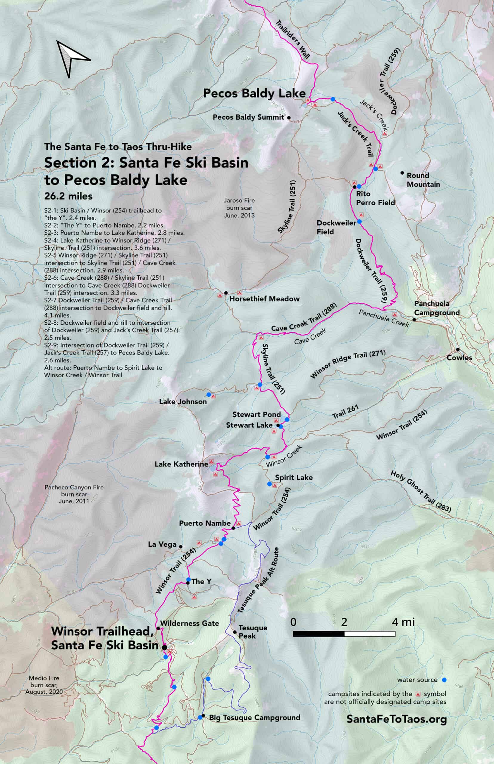
You can download and print this map in legal size (8.5″ x 14″, 19MB) and in tabloid size (11″ x 17″, 16MB). Note that most of the campsites shown on this map are not designated campsites.


Overview of Section 2
S2-1: Ski Basin / Winsor (254) trailhead to “the Y”. 2.2 miles.
- Start at the Winsor Trailhead at the Santa Fe Ski Basin (aka Aspen Basin). There’s good water here, “parking lot style” campsites, bathrooms, and a large parking lot, plus all the amenities for the Ski area (though I don’t know if the Ski facilities are open during the summer.). This is the last water for about an hour.
- Go past the big trailhead sign into the woods, cross the tiny creek over an 4-foot wide bridge about 30 feet beyond, and take a right immediately after.
- You’ll be on a wide, thoroughly-worn trail. The trail will bend back and forth as you go up the switchbacks, but will first cross a large new dirt access/utility road about 0.1 miles from the trailhead.
- Cross this access road. Continue up the switchbacks, passing a bench on your right along the way, until you get to the Wilderness Gate.
- Past the gate, you are in the Pecos Wilderness. All wilderness usage rules apply – namely no mountain bikes and no drones.
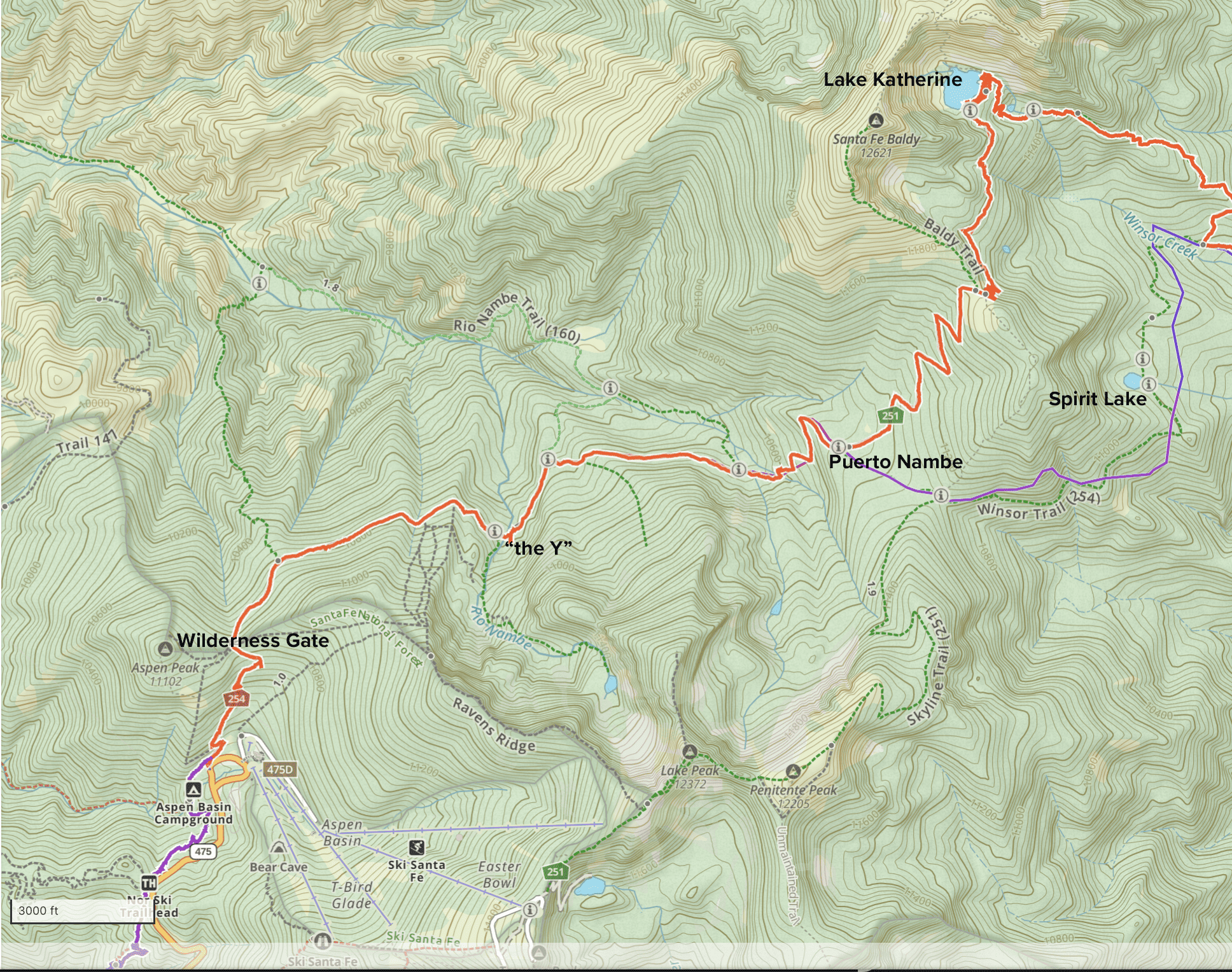
- Past the wilderness gate you’ll be on Winsor Trail (254) for 30-40 minutes before you reach the Y. Stay on the main trail. Do NOT take trail 403 (Lower Nambe Trail, aka “The Elevator Trail”) that goes down and to the left about 0.4 miles from the wilderness gate.
- Continue on Winsor Trail towards “the Y”. The trail is generally flat plus or minus a few rocky stretches and little slopes along the way. You’ll be among evergreens for the first bit after the wilderness gate. Pretty soon the evergreens give way to aspens. You will probably see quite a few people and dogs. This is one of the most popular trails in the entire Santa Fe area. I have, just once, seen a horse on this trail. You may also see glimpses of Santa Fe Baldy to your left, especially if the caterpillars have shredded the canopy the way they’ve been doing the last few years.
- The “Y” is a split in the trail about 200 feet before the Nambe River, aka Rio Nambe. You may hear the river from the split. The right side of the split (Nambe Lake Trail (400)) goes up to Nambe Lake. Nambe Lake is lovely, but also a dead end. Your route for the thru-hike continues on to the left.
S2-2: “The Y” to Puerto Nambe. 2.2 miles.
- After taking the left branch of the Y (i.e., staying on Winsor Trail), cross Rio Nambe about 200 feet later. The next water you’ll have access to is about 30-45 mins away.
- Continue along Winsor Trail. You’ll pass a trail on the left, Upper Nambe Trail (101) about 0.4 miles after you’ve left Rio Nambe. This goes to La Vega, which is a big field with little creek running through it. It’s a nice, out of the way place to camp for the night if you want. Note that the route of the thru-hike does not go through La Vega; it’s just a nice detour along the way. Expect cows, and probably a bull as well. The trail to it does have a bit of up and down. If you’re tired, stay on Winsor and camp in the fields just below Puerto Nambe.
- As you continue straight along Winsor Trail, with the trail will begin a gradual climb. You’ll be in shade, in mixed evergreen and aspen forest, with occasional views of Santa Fe Baldy on your left. On your way you’ll pass through a couple of enormous boulders, then pass Rio Nambe Trail (160) on your left. About 200 feet later you’ll cross two or three small streams before the trail gets steeper as you begin the climb up to Puerto Nambe.
- Right around where the streams are, particularly on the left, there are several fields plus a few protected spots that would make excellent places to camp. Puerto Nambe, where you’re headed, is nice and flat, but it doesn’t have the immediate water access that these little fields and shady spots have.
- The climb up to Puerto Nambe isn’t all that bad, but it is a climb. You will cross one or two very shallow rills that usually have enough water to carefully fill a Nalgene, especially if you have a shallow bowl to collect water in, then pour into the Nalgene.
- Puerto Nambe is an enormous sprawling field with evergreens dotted throughout. Some very old guidebooks refer to places like this as “parks”, and there is a bit of a park-like feel to it. There are ample camping sites, so spread out and go find a spot that’s not visible from the trail. Expect cows. Keep an eye out for grey and white Clarkson’s Jays. If you are patient, and hold still with a nut or a cracker in your open palm, one of the jays might land on your hand long enough to grab a treat.
- The most noteworthy thing in Puerto Nambe (besides the jays, and the nice alpine field, and the views of the ridgeline behind Nambe Lake) is the sign for the intersection of Winsor Trail (254) and Skyline Trail (251). You can’t miss it. It’ll be on your left as you haul up the very last bit of the climb and get your first look at Puerto Nambe.
- You can pick up Skyline Trail (251) and go left towards Baldy and Lake Katherine (and this is the standard route of the thru-hike), or you can go right, staying on Winsor, and go to Spirit Lake. The best way to go is via Baldy and Lake Katherine, but I offer the Spirit Lake route just in case there’s bad weather or if you’re tired. Or in case the woods are filled with people and you want to enjoy some peace and quiet at Spirit Lake. Spirit does not have as dramatic a view as Katherine, but it is still beautiful, and much less frequently visited.
- This trail marker at the intersection of Winsor Trail (254) and Skyline Trail (251) is the end marker for Section 2-2.
S2-3: Puerto Nambe to Lake Katherine. 2.75 miles.
- As you step on to Skyline Trail (251), you’ll walk through a bit more of Puerto Nambe’s fields and big lush evergreens. The trail will start to get steeper, and you’ll then be working your way up the switchbacks towards Lake Katherine and Santa Fe Baldy. It is a climb.
- Enjoy the views from the top of the saddle, but only if there aren’t thunderclouds around. Lightning is a concern. New Mexico has a surprisingly high instance of strikes.
- If the weather is clear, and you have extra amounts of energy, consider taking a detour up to the summit of Santa Fe Baldy. The trail for the peak is the left trail you’ll see when you get to the top of the saddle. Santa Fe Baldy peak is 1.1 miles from where the trail to it splits left.
- The weary (or the pragmatic) will want to continue on, taking the right fork of the split, to Lake Katherine. So walk over to the far/north side of the saddle and make your way down another set of switchbacks towards the lake. These switchbacks have some great views, also available from the saddle above. Even with the bark beetle damage, it’s still good. You’ll be able to see Truchas Peak in the far distance. If you’re doing the full thru-hike, or even just the first half of it, you’ll be just below Truchas Peak in a few days.
- Once you’re off the switchbacks you’ll go into forest again.
- Lake Katherine is one mile from the end of the switchbacks. There is a little climb to get up the last bit to it. It’s worth it. Unless it’s mobbed, throw your pack down and have a rest, just taking in the view.
- After a few minutes you’ll want to start scouting a place to stay. It is nice to be able to stay over; the way the light shifts from day to dusk to dawn is exquisite. The star gazing is exceptional, too.
- You may have to look around a bit for a quiet, secluded campsite. Try the far side of the lake.
- There are fish in Lake Katherine. Some people come here just to fish.
S2-4: Lake Katherine to Winsor Ridge (271) / Skyline Trail (251) intersection. 3.6 miles.
- From the northeast corner of Lake Katherine, approximately where a little creek (Winsor Creek) flows out of the lake and down, you’ll continue on Skyline Trail (251), heading down.
- On the way down you’ll pass a little pond on your left. Look for the supersized trout as you go by.
- The trail down the back side of Lake Katherine is a little rough in places, and you won’t see nearly as many people as you saw at Katherine or on your way to it. But it’s easily passable, and very well-worn.
- You’ll cross over Winsor Creek again on your way down, about 0.4 miles from the side of the lake. Then you’ll see it again, but won’t cross it, when you get to the bottom of the way down from Katherine and find yourself at the intersection of Skyline and Winsor Trail (again). (You were also at the intersection of Winsor and Skyline back at Puerto Nambe.)
- If you did the Spirit Lake alternate route, you’ll be coming out from there at this point as well. The trail down from Spirit (which would be Winsor/251) has a lot of blow down, but it is still passable. Just don’t expect to go fast.
- After you’ve walked down the last bit of the slope from Katherine you’ll take a left. The creek you’ll see on your right is Winsor Creek (again… same creek you found flowing out of Lake Katherine). Get water here if you want, but once you take the left and continue along Skyline, you’ll be only 0.6 miles from Stewart Lake.
- Stewart Lake is definitely nice. It’s just a bit overvisited for me. There is good fishing here. I even saw someone take a swim in it recently. There are campsites all around Stewart, both with views of the lake and then another series of campsite around what’s basically a wider concentric circle around the lake. Please do everyone a favor and be quiet, pick up after yourself, put your campfire out (or never light one to begin with), and pick up even one or two extra pieces of trash that people less conscientious than you left behind.
- The campsites around Stewart continue even after you’ve left it, crossing the wooden bridge over the little stream that flows out of Stewart on the east side of it. This is Skyline Trail (251).
- You’ll continue on Skyline as you walk along with a view of a large bog on your left and forest on your right. Then you’ll come up to “Stewart Pond” on your left, which has another campsite next to it. There are no fish in this pond, but there are neotenic tiger salamanders (which look a lot like axolotls). There are also some impressively-large leeches.
- As you continue on Skyline just past the pond, you’ll cross another little creek that flows from another part of the bog. This is your last water for 1.1 miles.
- About 200 feet past the little creek, on your right, you’ll see where Winsor Ridge Trail (271) breaks off from Skyline. Great trail, but it’s not on the route of the thru-hike. Keep going straight/left and stay on Skyline.
- The trail split of Skyline and Winsor Ridge marks the end of Section 2-4.
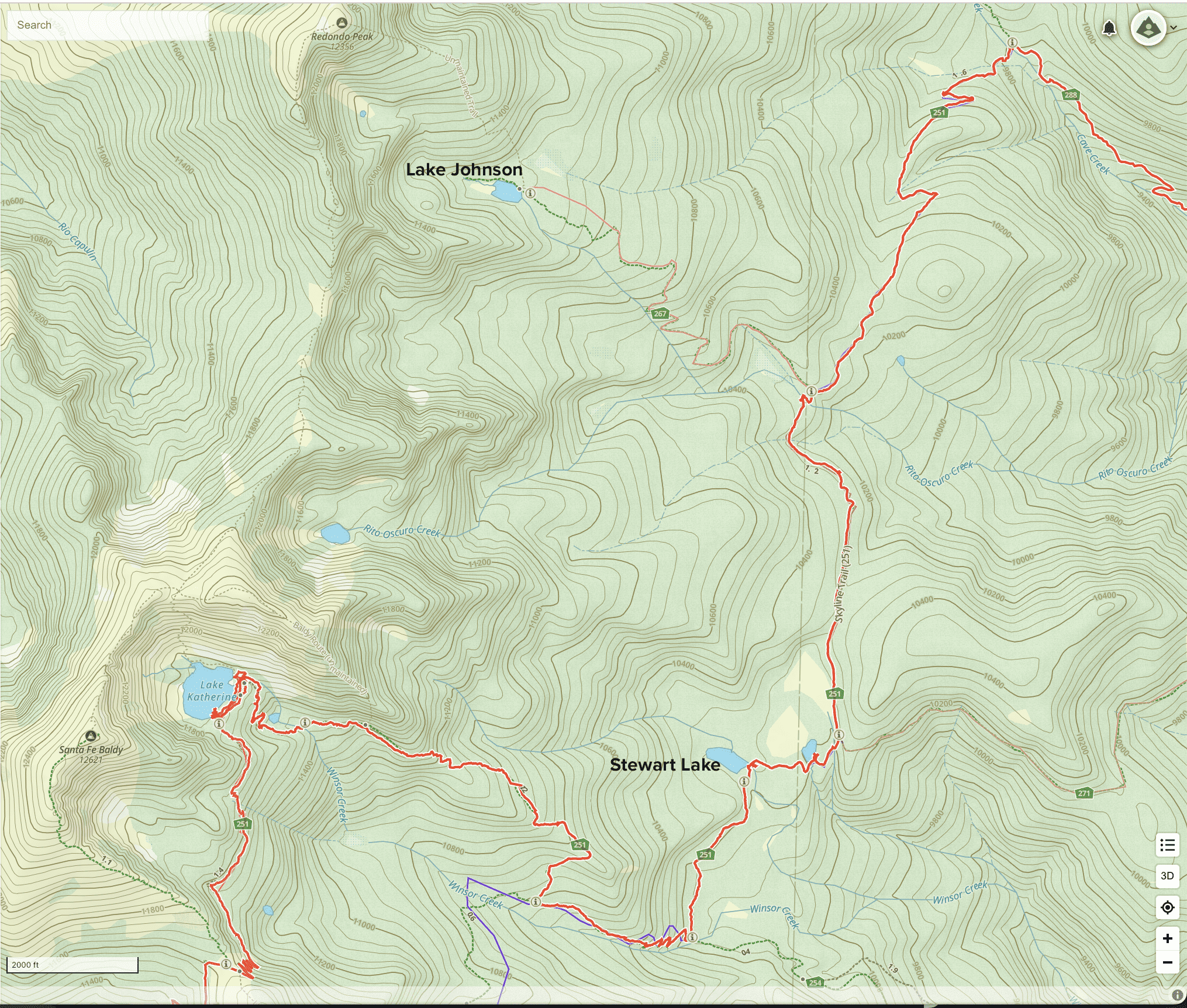
S2-5 Winsor Ridge (271) / Skyline Trail (251) intersection to Skyline Trail (251) / Cave Creek (288) intersection. 2.9 miles.
- After you take the left/go straight from the Skyline / Winsor Ridge trail junction, the trail (Skyline) becomes much less traveled. You may not see anyone the entire time you’re on this subsection.
- Continue on Skyline, passing that big bog on your left. There is some blowdown on the trail. The trees in this subsection, for whatever reason (heat, drought, bark beetle), have taken a beating over the last decade. Even when I went through in 2018, they were showing signs of extreme stress. Now many of them have died and fallen. There are views that weren’t there even five years ago.
- After 1.1 miles along Skyline Trail (251) you will cross Rito Oscuro Creek.
- About 300 feet after Rito Oscuro, you’ll see a trail sign and a trail going up and to the left for Lake Johnson. (The sign currently says “Johnson Lake”, but that’s wrong. It’s Lake Johnson.) Lake Johnson is a gem, but the trail up to it is rough. Again, the trees through this whole area have had some sort of extreme stress on them, and many (even most, I’m afraid, in some sections) have died. A decade ago when I was regularly going up to Lake Johnson, the whole way up to it had canopy. It was wetter. Now, with so much of the forest dead and lying as dry lumber on the ground, the sun makes the way up to Johnson even drier. I hope the trees that remain can live through this. I hope maybe the aspens fill in, and make the most of the decaying trees that cover the ground. Some good news is that if you brave the trail up to Johnson, the trees do become healthy again about a third of a mile or so before you get to the lake, and the trees around the lake are healthy.
- If you’re not up for getting to Lake Johnson, there is a hidden little campsite right behind your left shoulder, basically, as you’re standing on Skyline and looking at the sign for “Johnson Lake”. It’s only 20 feet or so off Skyline, towards the bog that’s to the left of the trail if you were going up Johnson.
- If you don’t need to stop, continue on along Skyline. The trail has ongoing issues with blowdown for the next 0.7 miles or so, but it’s easily passable. “Enjoy” or take note of the new view on the right of the trail at a very large boulder. You’ll be able to see Pecos Baldy, where you’re headed, and Truchas Peak hiding behind it.
- A bit after you get past most of the blow down, there’s a nice gradual set of switchbacks as you come down toward another wet area. There is a workable campsite near the bog, just as the trail takes a sharp right. Camp there, or keep walking toward Cave Creek and Cave Creek Trail. The next third of a mile before you reach Cave Creek has quite a few little fields and good spots to sleep for the night.
- When you reach Cave Creek, you’ll see the trail split left and right about 20 feet ahead of you. This is the intersection/junction of Skyline Trail (251) and Cave Creek Trail (288). Skyline Trail goes to the left (“upcreek”, as it were). Cave Creek Trail, and the route of the thru-hike, goes down, following Cave Creek itself down. This junction is the end of subsection 2-5.
- A note about the route of the thru-hike NOT going left, to Horsethief Meadow, and then following Skyline Trail to Pecos Baldy Lake: There is a burn area from about 1.5 miles beyond Horsethief Meadow all the way to just short of where Rito Perro Trail and Skyline intersect. I.e., a burn area that’s about 2 miles long. This section of trail is extremely lightly travelled, and also has a level of treefall that makes parts of it basically a dispersed logpile. As the years pass, and the log piles collapse and decay and merge with the ground, this route may become workable again. I have been watching this happen over the years; when I first went through in 2018, I had to take off my pack and crawl under at least three dozen trees to get across. When I went through most recently, in October 2023, I only had to take my pack off two or three times; most of the logs have fallen enough to climb over, though most to many are still 3-4 feet off the ground. I was very heartened to see aspen growth in this area, some of it almost 8 feet tall or higher (shade!) when I was last there in October 2023. It is very slowly coming back. We also all owe huge thanks to the New Mexico Volunteers for the Outdoors (NMVFO), who went through at least the west side of this trail, clearing several hundred fallen trees. The trail is much better than it was. Also, the one unburnt spot, right where Skyline crosses Panchuela Creek, is a really nice spot with shade, excellent water and several good spots for a tent. Consider taking a rest there if you go through this area.
- The original route of the thru-hike, from 2018, did go through this part of Skyline Trail (Horsethief Meadow and the burn). But after much consideration, and visiting this section of trail another four times in both directions over the last few years, I rerouted the route of the thru-hike to go down Cave Creek and up Dockweiler, through Jack’s Creek and up Jack’s Creek Trail to Pecos Baldy. This new route skips Horsethief Meadow but it goes over much better trail, has more water access, and is safer.
S2-6: Cave Creek (288) / Skyline Trail (251) intersection to Cave Creek (288) Dockweiler Trail (259) intersection. 3.3 miles.
- From Cave Creek the creek, take a right at the Cave Creek trail / Skyline intersection to go down towards Panchuela Campground. You’ll be next to Cave Creek the whole way down. It’s a very long down, but beautiful. The footing is a little dicey in spots. You’ll be glad you brought your poles, especially if you’ve got a heavy pack.
- There are camping sites on the way down, but they don’t meet the “rules” of proper campsites, in that most of them are either less than 50 feet from Cave Creek, or they are less than 50 feet from Cave Creek Trail. I can see why they came to be, though: for much of the way down, there isn’t a full 100 feet between Cave Creek Trail and Cave Creek the creek.
- There are caves just off Cave Creek Trail. The first one is 1.8 miles from the right you took just after you crossed Cave Creek, left Skyline Trail, and started on Cave Creek Trail. The second cave is about 300 feet down the trail from the first. They’re both about 100 feet off the primary trail, but there are little trails to each cave. I’ve never been in either cave.
- 2.4 miles from where you crossed Cave Creek and took the right, you’ll be at Panchuela Creek. This is a robust creek – almost a river by New Mexico standards. It’s about 12 feet wide and deep enough that you may not want to just walk through it. Fortunately, there is a line of fairly large stones that make a walkway across the creek.
- Take a right after you cross Panchuela Creek. You’ll still be on Cave Creek Trail (288). Continue down Cave Creek Trail, with Panchuela Creek running alongside you, on your right, the next 0.9 miles.
- At 0.9 miles from where you crossed Panchuela Creek, there’s a trail junction for Cave Creek Trail (288) and Dockweiler Trail (259). You’ll take the hard left up Dockweiler if you’re continuing on the thru-hike route. If you need an out, or even a supported resupply, the Panchuela Campground, trailhead, and parking lot are 0.8 miles down Cave Creek trail (still following Panchuela Creek).
- This trail junction is the end of subsection 2-6.
S2-7 Dockweiler Trail (259) / Cave Creek Trail (288) intersection to Dockweiler field and rill. 4.1 miles.
- From the trail junction of Cave Creek Trail (288) and the beginning of Dockweiler Trail (259), take Dockweiler up, heading north/northeast and away from Panchuela Campground.
- This is a long up. There are switchbacks, but it’s just a very long up. Possibly as much of a climb as up the switchbacks to the saddle before you got to Lake Katherine. From the trail junction with Cave Creek Trail to where Dockweiler finally starts to level off, you’ll go 2.1 miles and gain 1,500 feet of elevation.
- It is pretty, if that helps. For the first mile or so you’ll be in dry evergreen forest with very large dispersed trees. There are views as you climb; you’ll be able to see to the south and over to the east and some of Jack’s Creek Campground. As you continue to climb you’ll cross into some beautiful, if dry, aspen forest. It gets wetter (and the trees get healthier) as you go. By the time you’re where the trail levels off, the undergrowth is thick and the trees are vibrantly healthy.
- This is unfrequently travelled trail. You might see someone on the climb up, but after that you are unlikely to see anyone until you get to Jack’s Creek (the creek – not the trail or the campground). Trail conditions at the beginning, during the climb, are good. Expect a few fallen trees along the way after that. The biggest problem (not sure it’s a problem…) is how lush the undergrowth is. It can obscure the trail, and because this section of Dockweiler gets so little use, it would be understandable if you weren’t entirely sure where the trail is at points, especially if we’ve gotten good moisture and the plants are having a vigorous growth season. So bring a gps device, with downloaded maps, that works without cell reception… you know the drill. If you’re doing the full thru-hike, please bring a printed map as well, just in case something happens to your phone.
- Note that there is purportedly a side trail to Dockweiler. A loop. I have never been able to find the loop part of this trail, and I have looked for it on both ends of the loop, with my phone out, mirroring where Gaia and my Garmin say the trail is supposed to be, step by step. I still haven’t been able to see anything resembling a side trail, even an animal trail. Maybe it’s there. Maybe not. So I recommend you stay on the main part of the Dockweiler Trail, even if you should be able to find this secret path.
- A little bit over a mile from where Dockweiler levels out, there is a field with an unnamed little creek about three feet wide running through it. The field spreads out on both sides of the trail. It’s mostly not level, but there are several level spots you could place a tent on and enjoy a very nice spot for the night.
- Or you could just continue on for another 0.9 miles to the intersection of Dockweiler Trail and Rito Perro Trail (256). This is also a very lovely field, and much larger. It has no water immediately in the field, but if you walk further down Dockweiler for about 5 minutes there’s a nice little creek that is a tributary to Jack’s Creek. It’s shallow, but reliable. There’s also a good view of Round Mountain from this field (“Rito Perro field”?) at the intersection of Dockweiler and Rito Perro. This intersection, at the trail sign, also marks the end of section 2-7.
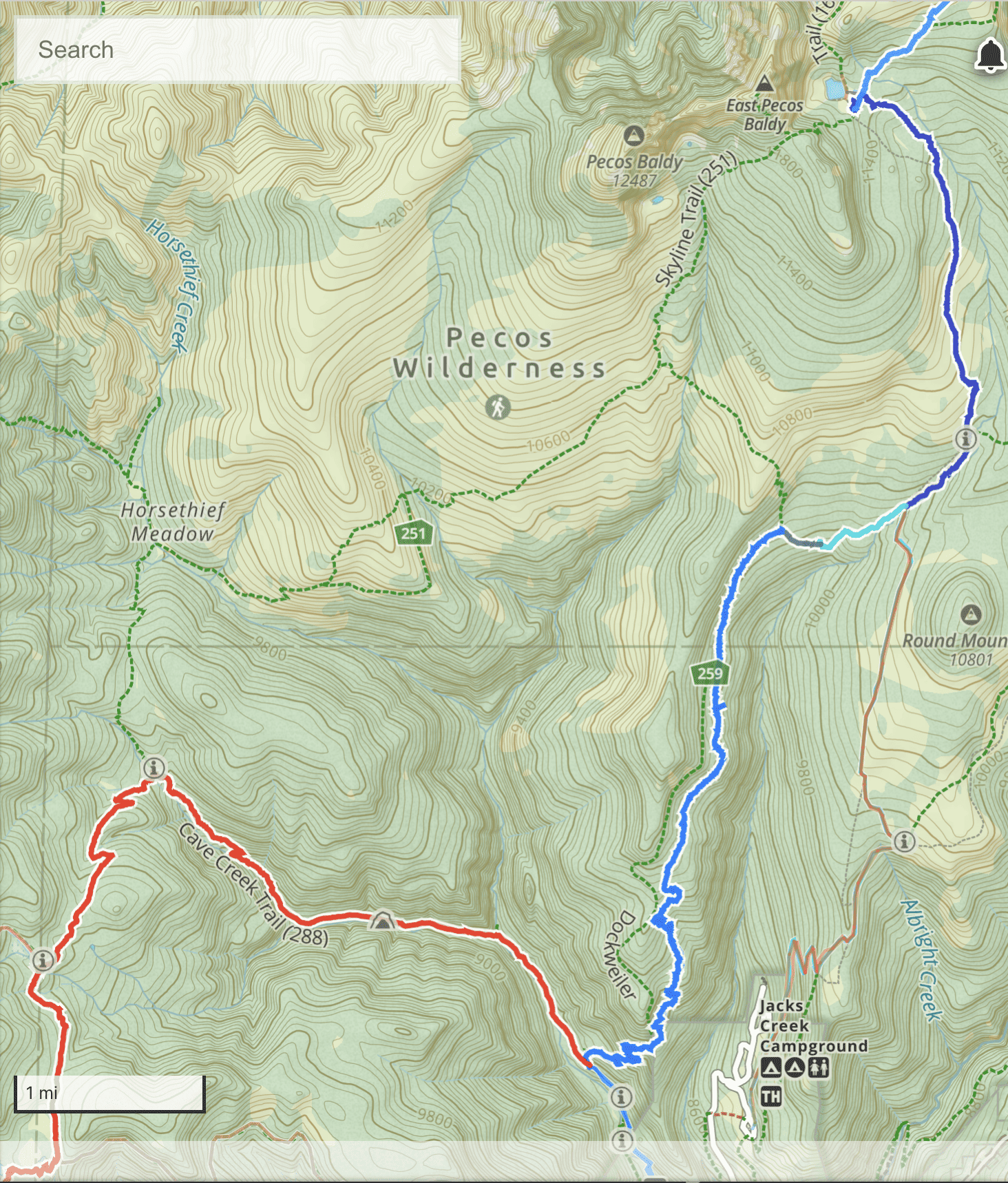
S2-8: Dockweiler field and rill to intersection of Dockweiler (259) and Jack’s Creek Trail (257). 2.5 miles.
- Continue on Dockweiler towards Jack’s Creek the creek. There’s a good water source about 5-10 minutes from the intersection with Rito Perro. It’s shallow but – as mentioned earlier – reliable.
- You’ll be walking through more mixed evergreen and aspen forest, mostly in shade. It gets wet through here; the trail is muddy in spots. There are a few nice little fields along the way that would work if you wanted to crash for the night. I stayed at one in October few years ago. The fall foliage is exceptional all through this section of Dockweiler.
- There’s also a pond 0.3 miles before you get to Jack’s Creek the creek. The trail will go up a bit as you approach Jack’s Creek (both the creek and the trail). You’ll see a field and some obvious camping spots as you approach Jack’s Creek and the intersection of Dockweiler Trail (259) and Jack’s Creek Trail (257).
- Note that this is not the end of S2-8; that’s about two miles north along the trail. Dockweiler and Jack’s Creek are the same northwards-bound trail for the next half mile.
- This southern intersection of Dockweiler and Jack’s Creek is a major junction for hikers. I am always tempted to call it “Jack’s Creek campground” because there are so many camping sites around here, and because so many people use it. However, there is an “official” “Jack’s Creek Campground” (and “Jack’s Creek Horse Camp”) about 4.1 miles across the creek, and southward bound on Jack’s Creek Trail. There’s a paved road to Jack’s Creek Campground, and parking lots, and rentable campsites, and public toilets, and everything. If you need an out, there’s your out.
- There is almost always someone around this “Jack’s Creek” intersection area. In summer, there can be over 100 teenagers staying in or around Jack’s Creek intersection.
- The route of the thru-hike continues north, on Jack’s Creek (257) / Dockweiler Trail (259) for another half mile. Jack’s Creek will be on your right for the first quarter mile or so, and then the trail pulls away from it. There are campsites hidden off trail all along, well away from the primary trail junction you passed through earlier.
- 0.5 miles from the “southern” intersection of Dockweiler and Jack’s Creek you will come to a trail sign making the “northern” intersection of Dockweiler and Jack’s Creek Trails. This is the end of Section 2-8. The thru-hike route continues left, on Jack’s Creek Trail.
S2-9: Intersection of Dockweiler Trail (259) / Jack’s Creek Trail (257) to Pecos Baldy Lake. 2.6 miles.
- At the north junction of Jack’s Creek Trail (257) / and Dockweiler Trail (259), take Jack’s Creek Trail north.
- You’ll be heading up a little hill, then will continue along well-worn trail into a burned area. You will be able to see the first line of dead trees within about 100 feet.
- The burn happened around 2016. This is the same burn that caused the reroute from Skyline Trail between Horsethief Meadow and Rito Perro Trail. The burn area extends all the way from here to that section of trail and up to just short of the peak of Pecos Baldy. (There are two Pecos Baldys. The southwestern one is “Pecos Baldy”. The northeastern one, where you’re headed is “East Pecos Baldy”).
- As you’ll see when you walk through this 1.1 part of the trail, the grasses have mostly filled in. The trees and shrubs are coming in, but very slowly. The aspens have not decided to grow here yet.
- This part of the route is not heavily traveled, but you will probably see about half a dozen people on your way towards Pecos Baldy Lake.
- After about a mile through the burn you’ll go back into tall evergreen forest. Another 0.5 miles later you’ll cross a nice little unnamed creek that’s about three feet wide.
- Back to the directions: The trail begins to go up and down in little 50 ft dips and rises through evergreen forest as you get closer to Pecos Baldy, then it flattens out almost perfectly as you go through more open forest, then what’s basically grassland with interspersed trees. You will cross a significant (8 feet wide) stream about 0.4 miles from Pecos Baldy Lake.
- About this unnamed creek: It’s in the right area to be Jack’s Creek the creek, but none of the maps (National Map, Gaia maps, Historic Topo 1980) show Jack’s Creek crossing Jack’s Creek trail here. It does appear to be unnamed, which is odd, because it’s a pretty robust creek for New Mexico.
- There is a final climb once you’re past that creek, but it’s short. You’ll come up and see the trail sign and intersection for Jack’s Creek and Skyline Trail. Skyline Trail (251) will be crossing from left to right.
- As soon as you’ve noticed the trail sign, you’ll inevitably be pulled forward by your first glimpse of Pecos Baldy Lake. It is a large, shallow lake, framed by a bowl of the land with Pecos Baldy rising up behind it. Walk down the last 0.1 miles to the edge of the lake, or lean up against the one lone huge ponderosa, and have a nice rest taking the view in.
- There are campsites all around the lake basin, on every side of the lake except the very steep up that is the face of East Pecos Baldy on the west side. Mind the overflow that goes into an underground stream at the southeast corner of the lake. I wouldn’t let children play around that unsupervised.
- The weather can get intense up here. High winds and hail are common. I was out here in early November over a decade ago and the winds were so powerful my tent bent down to touch my shoulder as I was lying in the sleeping bag. Another fun story: I was here once in spring and got to see a tent floating on the lake. Someone had not staked their tent down fast enough or well enough, and there was a good gust, and… we all got to see how well bathtub floors work in tents.
- If you stay overnight: Get out and look at the stars. From this altitude, this far away from artificial lights, they’re amazing.
- You will inevitably notice the bark beetle damage to the trees. It’s heartbreaking. We can only hope the trees will grow back, or be replaced by different species, or at least that as the dead trees fall (hopefully not on your tent) they’ll be less depressing. The bark beetles had not previously made it this far up because the cold kept them back. As this region has become warmer, the range of the bark beetles has expanded, allowing them to reach trees that are especially vulnerable to them. Also, of course, as we have gotten less and less snow, it is not as wet up in the higher elevations as it used to be. That, too, has had its effect on the trees.
- If you have extra energy (especially after you’ve taken you pack off and got your tent set up), consider taking the trail up to the summit of East Pecos Baldy. It’s 1.3 miles each way from the summit to the intersection / trail marker for Skyline and Jack’s Creek Trail.
- There could be big horn sheep around, but they don’t come around the lake as much as they used to. The Clarkson’s Jays are here, too, if you want to try to get another one to land on your hand.
- Pecos Baldy Lake marks the end of section 2-8 and the end of all of Section 2.
