

Section 4: Santa Barbara Campground to Forest Road 442
- S4-1 Santa Barbara Campground free parking lot to intersection Indian Creek Trail (27) and Bear Mountain Trail (28). 2.1 miles. (Gaia map)
- S4-2: Intersection of Indian Creek Trail (27) and Bear Mountain Trail (28) to intersection Indian Creek Trail (27) and Divide Trail (36). 2.6 miles. (Gaia map)
- S4-3: Intersection Indian Creek Trail (27) and Divide Trail (36) to Los Esteros. 1.5 miles. (Gaia map)
- S4-4: Los Esteros to intersection of Agua Piedra Creek, Trail 19A and Trail 22. 3.8 miles. (Gaia map)
- S4-5: Trail 19a/22/Agua Piedra Creek to Agua Piedra Campground entrance. 1.9 miles. (Gaia map)
- S4-6: Agua Piedra Campground bridge/entrance to La Cueva Canyon / Trail 492. 0.9 miles. (Gaia map)
- S4-7: La Cueva Canyon / La Cueva Trail (492) to intersection of La Cueva Trail (492) and Ojitos Maes Trail (182). 1.7 miles. (Gaia map)
- S4-8: Intersection of La Cueva Trail (492) and Ojitos Maes Trail (182) to intersection of Ojitos Maes Trail (182) and La Cueva 8. 1.4 miles. (Gaia map)
- S4-9: Intersection of La Cueva 8 and Ojitos Maes Trail (182) to Forest Road 442. 2.7 miles. (Gaia map)
18.6 miles Section 4
Gaia maps (digitized step-by-step tracks) of this section are here. It may be helpful to have multiple browser windows open on a computer (not a phone) so you can read the directions, see the photos, and follow along on the maps at the same time.
GPX files for each sub-section can be downloaded from the Gaia links above. You can also download the merged GPX files here as one GPX file for Section 4.
Here’s my own map for Section 4:
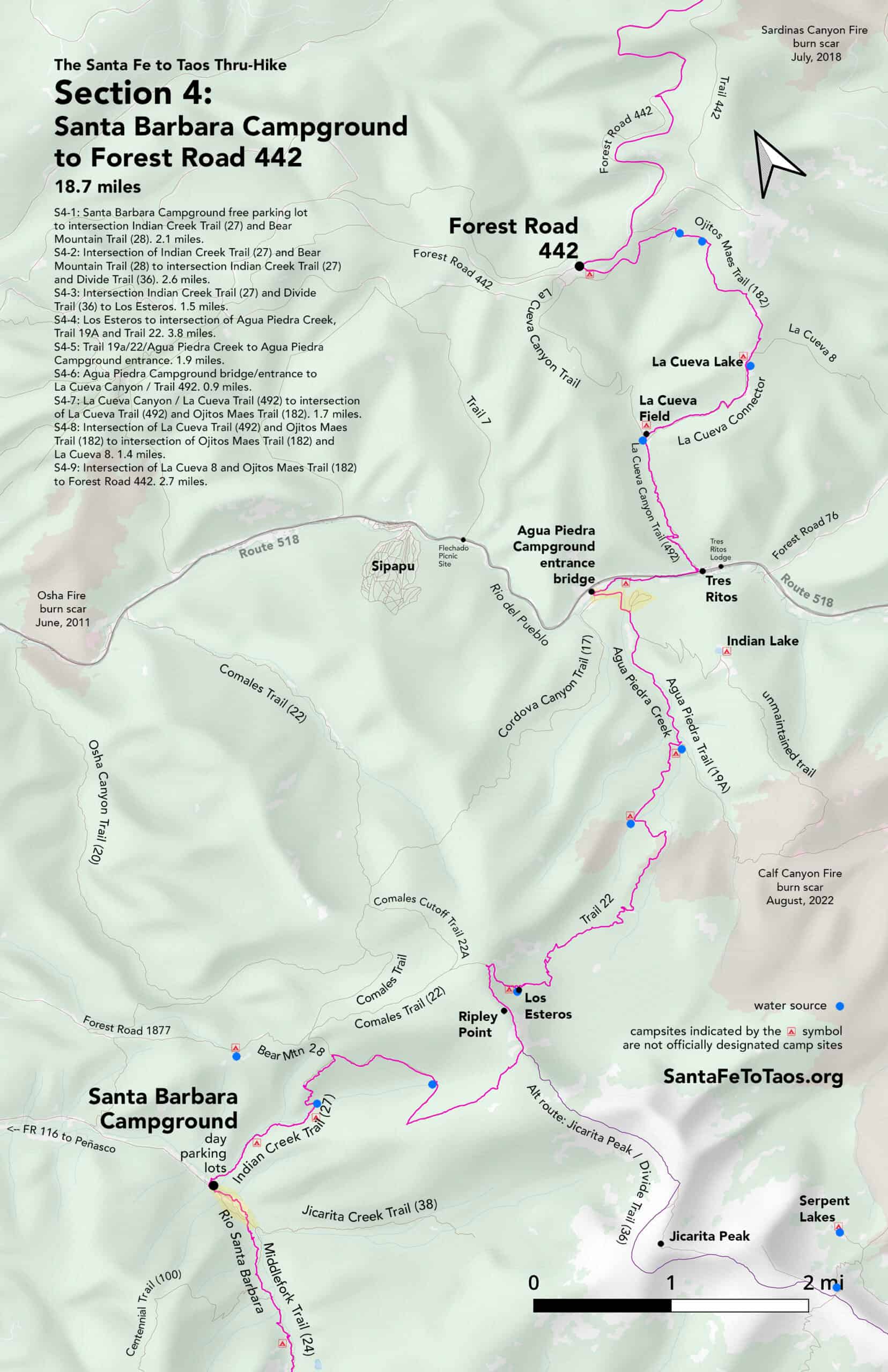
If you click on that image it will open into a separate window and you’ll be able to see more details. You can also download this map for printing. It’s available in legal size (8.5″ x 14″, 11.7 MB) and in tabloid size (11″ x 17″, 10 MB). The campsites shown on the map above are not official campsites, but they are flat, sheltered areas near a water source where you can get a bit off trail for some privacy.


Overview of Section 4
Do follow the Gaia maps on your phone while you’re on the trail (the paid version of Gaia works without cell reception) but here’s the text version of the walk just for extra information.
S4-1 Santa Barbara Campground free parking lot to intersection Indian Creek Trail (27) and Bear Mountain Trail (28). 2.1 miles. (Gaia map)
- Start at Santa Barbara campground, near the free parking lots on the far north end of Santa Barbara campground. They’ll be on your left, alongside the river, right as you come into the campground area. There are about four parking spaces easily visible from the road, then another lot for about 20+ cars about 100 feet north (downriver) from that.
- In this section you will be going up into Indian Canyon, over Ripley Point, and then down into Agua Piedra Campground. This area is much less traveled than Middle Fork Trail (24) that you came in on. You probably won’t see anyone until you reach Agua Piedra Campground.
- The trail marker for Indian Canyon Trail (27) is on the far side of Rio Santa Barbara. It’s about halfway between the two parking lots on the opposite side of the river.
- You may want river shoes to cross Rio Santa Barbara. You could just walk across in your bare feet, but people do fish in this creek (and thus sometimes leave hooks behind) and the rocks are not smooth. You’ll risk tearing up your feet right at the beginning of this section. If you had someone offering trail assistance, you could use river shoes to get across the creek, then toss the river shoes back to them across the creek so you wouldn’t have to carry them the whole way.
- Rio Santa Barbara is about 15 feet wide. In the spring melt, or after a significant rain, the river can move fast. Consider getting your poles out to steady yourself across. Consider putting your most water sensitive gear in a drybag before you cross. (And you have backup navigation tools, just in case something happens to your phone, right?)
- There’s a nice little grassy area 30 feet beyond the river with a couple of fallen logs that are ideal for sitting on while you change your shoes. From this point, you’ll cross a wet but barely flowing creek bed, then another shallow trickling “creek” about eight feet wide 500 feet later.
- About 0.2 miles from Rio Santa Barbara you will go through a gate. Please close it behind you. Twice I’ve had to climb over this gate, but in the last few years it’s been open more often.
- You will now begin a gradual and then steeper climb through tall forest with Indian Creek on your left, about 50-250 feet from the trail the whole way. There are plenty of spots along here to put a tent if you want to crash for the night, though you might want to continue just a little bit further to Bull Field and the creek that runs just to the north of it.
- Expect to see cows as you begin your climb up to Bull Field, and when you arrive at Bull Field. Almost every time I’ve been up here, there have been cows.
- Bull Field is 0.8 miles from Rio Santa Barbara. It’s about two acres. The trail is faint through the field. Head east through the field if you’ve got your compass out, or just head somewhat straight, veering to the left a bit (like 10 on a clock if straight ahead was 12). The trail goes back into the woods again and will cross Indian Canyon Creek roughly 0.25 miles from where you first stepped on to the field. Where the trail goes back into the woods is pretty obvious. It’s a wide, well-worn track.
- Indian Creek is about five feet wide and has enough water to easily fill a nalgene. This is your last water source until you cross Indian “Creek” again in about 2.5 miles, where it will have about 1/4 as much water flow.
- Indian Creek Trail (27) crosses Indian Creek and then begins a climb up through full-sized aspen. You will be walking up into a bowl shaped area, now with Indian Creek running along your right. There’s a bit of a cathedral feel as you walk up this trail towards a grassy slope.
- The trail takes almost a uturn here left, continuing up the hill. The trail is very well worn. It is somewhat of a climb, but the footing is good. You’ll have a nice view by the time to you get to where the trail turns right again and goes further into the aspens.
- The trail will flatten out a bit, but then get steeper as you climb up through mostly aspens with some evergreens. It’s good trail, though there can be a fallen tree every so often. You’ll be able to see the hills just to the west of you (the far side of Indian Canyon, basically) through the trees in spots.
- After the climb – 832 feet of elevation in the 0.8 miles from where you crossed Indian Creek – you will walk up to a trail split. Bear Mountain Trail (28) will go off to the left. Indian Creek Trail (27) continues on to the right. This is the end marker for Section 4-1.
S4-2: Intersection of Indian Creek Trail (27) and Bear Mountain Trail (28) to intersection Indian Creek Trail (27) and Divide Trail (36). 2.6 miles. (Gaia map)
- Take the right on Indian Creek Trail (27), heading southeast (and so walking away from Bear Mountain Trail). You’ll be on a wide, well-defined trail that goes through mixed aspen and evergreen shade. It’s pretty much flat with very gentle inclines for the next 0.3 miles plus.
- The trail will bend very gradually left and then right, and then begin to climb just a little bit before it levels out again. You’ll be going through a section of cleared blowdown. I don’t know who cleared this area, but I’m sure glad they did – otherwise this section of trail would have been only just barely passable. But it is cleared, and the trail on the ground is still wide and extremely well-worn.
- About half a mile later you’ll come to a steep field on your left with views to the west. The trail will leave the shaded woods briefly for a couple hundred feet in open sun, then will go back under the canopy again. Right about where the canopy begins, you’ll cross the little rill, trickly “creek” that is Indian Creek. This little creek is reliable, if shallow.
- Notice the collapsed wooden cabin about 150 feet off to the west (downslope) of the trail.
- Continue on Indian Creek Trail (27), going through what becomes almost entirely evergreen forest with thick mosses and large patches of the plant Kinnikinnick here and there. The trail is still wide and utterly obvious.
- 0.4 miles from where you crossed the trickly version of Indian Creek, the trail takes a sharp left and gets steeper. There will be more and more blowdown over the next 0.6 miles.
- This is where Indian Creek Trail begins to get a little dicey. The good news is that you’re coming into a surprisingly wet area. There are mud puddles and seeps and little trickles of water in several places. There is blowdown, and the ground is torn up by what I suspect was cattle. The problem with all this is that as people or animals have made their different mini-routes around the blowdown and the mudpuddles, it gets harder and harder to follow the trail. You are also going up, in some places quite steeply up. This goes on for about 0.3 miles before all the different detours converge back into an obviously “official” trail. Hopefully you will have a GPS unit with you; last time I went through here I had the Gaia app up on my phone and in hand and was looking at the screen pretty much every 20 steps. The next time I go through here I will bring trail tape to mark the way.
- If you are not superfit, you might want to take a brief rest here. It will help you think more clearly, which will make staying on the trail easier. You are, after all, at 11,400 feet by the time you’ve reached this point. If you live at sea level, that’s a lot of altitude to adjust to. Superfit young guys just in from the east coast, the sort who can run 20 miles a day, have actually had to be taken off the trail from this area and brought to a medical facility due to the altitude. So you’re not a wimp if you’re tired. Just rest for a bit. Drink some electrolytes. A brief rest may also keep you from injuring yourself, which would also be a good thing.
- Once you’re through the little snarl of boggy trail, you’ll climb up through evergreens that get shorter and shorter. These will give way to more grassy areas and the trees will get more spread out as you reach the top. At one point you will walk through the left side of a full-on field or open grassy slope.
- As the trail gets flatter and flatter, you’ll walk into a very strange, 40 foot wide “corridor”, basically, that runs for at least half a mile along the top of Ripley Point. The corridor, unfortunately and inexplicably, has been created because all the trees in it have been torn up. I cannot discern how or why this happened. I didn’t notice any clean cuts, like from a chainsaw… it’s really like all the trees were just churned up. In the middle of this mess, as you walk into it, is the trail marker for the intersection of Indian Creek Trail (27) and the Divide Trail (36) (Note: It’s not the Continental Divide Trail). If you took the alternate route over Jicarita Peak in Section 3, this is where you’ll rejoin the primary thru-hike route.
- This trail marker marks the end of Section 4-2.
S4-3: Intersection Indian Creek Trail (27) and Divide Trail (36) to Los Esteros. 1.5 miles. (Gaia map)
- From the intersection of Indian Creek Trail (27) and Divide Trail (36), head north on the Divide Trail. If you are coming up from Indian Creek Trail, this will mean you’re taking a left at the trail marker.
- Follow the trail on the right side of the torn up trees. You’ll have vast views to the east on your right.
- In less than 0.1 mile the trees on either side of you will open up and you’ll be on what feels like a typical mountaintop — exposed, rocky soil, with much smaller twisted trees. You will pass through a fence, but keep heading north/straight ahead. Divide Trail can get a little hard to follow through here, but you are basically going just to the right of the top of Ripley Point (11,791), then down the other side. Turn around for a quick look at Jicarita Peak, which will be almost exactly behind you.
- 0.4 miles from the top of Ripley Point, and 0.9 miles from the Indian Creek Trail and Divide Trail marker, you’ll reach the trail marker and intersection for Trail 22 (called “Comales Cutoff” on the National Map, and shown as Trail “22a” on the USFS Visitor map). Take the right on to Trail 22 and head down a somewhat steep slope. As you come down the slope you’ll go back into dense evergreen forest.
- 0.5 miles from the turn on to Trail 22 you will walk right into a nice flat, protected area and then up to Los Esteros on your right. It’s a boggy little pond, but it’s water. Getting to the water can be tricky because the sides are so boggy, but I had good luck filling up a few nalgenes on the east side of it. There are ample places to camp around the pond.

S4-4: Los Esteros to intersection of Agua Piedra Creek, Trail 19A and Trail 22. 3.9 miles. (Gaia map)
- From Los Esteros you’ll make your way down towards Agua Piedra (the creek and the campground) through some very lovely country. It’s the usual mix of aspen and evergreens with lots of shade plus many large fields. The trail is generally good though there are spots with blowdown.
- 2.6 miles from Los Esteros you’ll cross a nice unnamed creek that’s a good reliable water source. Another 0.9 miles from there you’ll cross a tributary to Agua Piedra creek.
- 100 feet after crossing that tributary, you’ll come to the trail marker of Trail 22 and Agua Piedra Trail (19A). This is the end point for Section 4-5.
S4-5: Trail 19a/22/Agua Piedra Creek to Agua Piedra Campground entrance. 1.9 miles. (Gaia map)
- Time to stroll into Agua Piedra Campground. From the intersection of Trail 22 and Agua Piedra Trail 19a, take the left, heading north on Agua Piedra Trail (19a). There are fields you could put up a tent in if you want to stop for the night.
- You’ll cross another little tributary to Agua Piedra Creek in 0.2 miles from the trail marker, then cross Agua Piedra Creek itself another 0.1 miles later. Your boots will barely be dry by the time you cross the creek again 0.4 miles later.
- About 0.3 miles later, as you are walking along a wide, straight, flat trail through tall evergreens, you’ll see a wilderness gate. As you pass through the gate you’ll see a large field right in front of you. At the far side of this very large field (so far you may not see it) is a horse corral, a small parking lot, and the edge of Agua Piedra Campground.
- Follow Trail 19A as it bends to the right of this big field. The trail goes up and down a little, just outside the edge of the field, still in shade.
- About 0.2 miles from the wilderness gate, you’ll pass Indian Lake Trail (19c) on your right. If you are ready to rest for the night and you don’t have a reservation at Agua Piedra Creek, and you’re up for 1.5 miles (and 852 ft of elevation), this is your best bet for a campsite until you reach La Cueva field, which is about 3.5 miles away.
- After you pass Indian Lake Trail (19c) it’s just 0.3 miles to the edge of Agua Piedra Campground. Walk through the campground, taking the left road from where you step out of the woods. You’ll walk along a paved two way road, going over Agua Piedra Creek one last time. Follow the road out to the entrance to Agua Piedra Campground and the bridge that goes over Rio del Pueblo. That bridge is the end of Section 4-5. The highway just beyond it is NM 518.
- Resupply opportunity: The Sipapu Ski Lodge is a resupply point. Sipapu is 2.2 miles from the Agua Piedra bridge. Most unfortunately, there is no public transportation to it, and there is no off-road trail. You’re going to have to walk northwest on 518 to get to it. Most of that distance, there will be a fairly large shoulder on the side of the road for you to walk on, but it is not ideal. The good news is that if you mail yourself a package to Sipapu (Sipapu Ski & Summer Resort, 5224 NM-518, Vadito, NM 87579), they will hold it for you. They offer this service for free. I would call ahead to confirm your package is there before you leave, but they have been doing this for hikers for quite a while now.
- Sipapu rents cabins and rooms year round. They have a restaurant, a store, and a little gas station. If you wanted to take a “zero day” or rest for a few days, Sipapu is your best, nearest option, at least until the Tres Ritos lodge reopens.
- I have stayed at Sipapu in one of their suites. It wasn’t fancy, but it was very functional. They are okay with dirty hikers, and they are okay with even a group of dirty hikers staying in a suite. The kitchens are well-equipped with dishes, pots and pans, and utensils. The water is hot. The heat works well, though it’s loud. In addition to the king-sized bed in my suite, there were also four bunk beds. It was about $130 a night in the off season. They accept dogs in some units.
S4-6: Agua Piedra Campground bridge/entrance to La Cueva Canyon / Trail 492. 0.9 miles. (Gaia map)
- From the Agua Piedra bridge, face the highway. In this section you will be walking to the right across the field, past the picnic tables, then parallel to the highway on an interpretive trail, then briefly along the highway, and then taking a left into La Cueva Canyon about a mile from where you are now.

- To get to the path that runs next to the highway, walk away from the bridge and towards the highway about 50 feet. If you look right, you’ll see a large grassy area, then a little further, you’ll see a small parking lot, and a picnic area, and a trail sign all about 200 feet apart from each other. Walk through the field over to the picnic area and the trail sign. (Note that there is a trail that goes right along Rio del Pueblo, but after 100 feet or so it’s grown over and blocked by fallen trees and is just generally not good passage. Walking across the field is easier.)
- When you reach the picnic table, keep going until you get to the trail sign. There is a paved walkway that goes in three directions in front of the sign. Follow the walkway branch that goes toward upriver. You’ll walk next to the river for about 0.2 miles, then out on to Rt 518. Look for the “gnaw or die” sign on your left as you walk by; it’s part of the “interpretive trail” information. There are also a couple of benches along this path.
- The little trail passes a muddy spot where Rio del Pueblo overflowed, but it’s easy to get by it. A very short bit later the trail bends away from the river and you’ll walk out on to 518, walking east/southeast on 518 toward Tres Ritos. The shoulder for the road is very wide here – 12 feet or more. It’s also a straightaway, so you’ll see any car coming up and they’ll see you. Continue on 518 for 0.4 miles, with Rio del Pueblo on your right. You’ll see the buildings of Tres Ritos shortly.
- The entrance to La Cueva Canyon will be on the left side of the road. It goes through a little clutch of houses. Please be quiet and respectful. La Cueva Canyon Trail (492) starts near a trail sign about 700 feet into the canyon.
- Section 4-6 ends right at the entrance of La Cueva Canyon, just off 518.
- For day hikers: You can’t park at the entrance of La Cueva Canyon. You have to drive towards Agua Piedra campground about one-quarterish of a mile from the entrance and park at a small, paved paving lot, then walk over to the entrance to La Cueva Canyon.

S4-7: La Cueva Canyon / La Cueva Trail (492) to intersection of La Cueva Trail (492) and Ojitos Maes Trail (182). 1.7 miles. (Gaia map)
- Walk away from Route 518 into the entrance to La Cueva Canyon, passing a couple of cabins and little houses. The beginning of the trail is clearly marked, and the trail itself well-worn. There is a small creek that runs along on the left for the first 10 minutes or so. This is your last access to water until you get to La Cueva field, which is only about 1.5 miles away.

- It’s a bit of a climb for the next half mile, but nothing too bad. You’ll be under mixed aspen and evergreen canopy, with an interesting assortment of wildflowers. The trail flattens out after half a mile. It stays flat for the next half mile as you go through some lovely wildflower-strewn fields on your way to La Cueva Field. By the time you see the old collapsed cabin just off the trail on your left, you’ll probably be getting your first views of La Cueva Field.
- La Cueva Field is big; probably about 15 acres. It is long and narrow, like a football field. There is a robust little creek on the left/west side of it; you’ll probably hear it as you walk past it. Somewhere along the edge of La Cueva Field, particularly toward the back of it, would make a great place to camp for the night.
S4-8: Intersection of La Cueva Trail (492) and Ojitos Maes Trail (182) to intersection of Ojitos Maes Trail (182) and La Cueva 8. 1.4 miles. (Gaia map)
- Finding where La Cueva Trail and Ojito Maes Trail (182) (also referred to as “La Cueva Cutoff” on some maps) intersect can be tricky. This section of Ojito Maes (aka “La Cueva Cutoff”) trail does not exist on several maps. It does exist on The National Map, and it is named there as “La Cueva Cutoff”. Hopefully you have a GPS device with you, so you’ll be able to follow the route with that. If you don’t, know that if you’ve actually crossed the little creek (that had been on your left when you were about 1/3 of the way into La Cueva field), you’ve gone too far. The little creek appears to be unnamed, but I think we can safely refer to it as La Cueva Creek.
- To find where the trails meet, look for an old metal boxspring of a bed on the left side of the trail. About 150/200 feet past the that boxspring (so north of the boxspring) is where you should turn right/east and head up the slope.
- After walking about 250 feet up the slope, you should see a large wooden bench. The bench is under a couple of big ponderosas (evergreen trees). The bench is about 12 feet long, sitting on two short tree logs. It is right next to the trail known as La Cueva Cutoff.
- Despite this little hiccup with the trail in La Cueva Field, the trail from here and up to La Cueva Lake is well defined. It is rough and steep. It’s had some erosion issues over the years, so it’s one of those trails that’s become a bit of an earthen chute, with the edges of the trail dropping down steeply toward the center, and the center of the trail being somewhat unwalkable in sections. I came down it at the beginning of some weather, hurrying to hopefully get to my car before I got soaked. Fortunately I had poles and I never fell, but I had to slow down quite a bit, picking my way down this.
- La Cueva Cutoff levels out in about half a mile. It comes up into a massive field with excellent views of the far mountains and lots of wildflowers. When you get to the field, you have just finished the last significant climb you’ll have to do until the very short one just before Forest Road 442.
- This field you’ve walked up into is about 0.4 miles from La Cueva Lake. You’ll be walking through a flat, open grassy area interspersed with groves of trees (big enough to provide good shade) on your way to and from the lake. It’s pretty. Camping anywhere around here would work.
- La Cueva Lake itself might be a bit of a disappointment, but it is open water. It’s just boggy. It’s in the middle of a very large field, with one or two lone cottonwoods about 300 feet from it, plus a fallen and very long dead cottonwood log that makes a great place to sit and contemplate how you might get close enough to the “lake” to get water without sinking into the mud/bog.
- I was able to get out far enough towards the lake to quickly fill up a nalgene using the two nalgene method (tip nalgene #1 sideways enough to capture water, pour what you can get into nalgene #2, repeat process.). I did have to move around a bit to keep my feet from sinking in, and it was not the safest thing I did that day. But it worked. It looks like the east side of the “lake” might have a better edge for getting water. I did not investigate that.
- Continuing along the La Cueva Cutoff, about 0.1 miles from La Cueva Lake you will come up on something between a dirt road and a forest track on your right. This is “La Cueva” or “La Cueva 8” depending on which map you’re looking at. It is, clearly, something that could be used for offroading vehicles.
S4-9: Intersection of La Cueva 8 and Ojitos Maes Trail (182) to Forest Road 442. 2.7 miles. (Gaia map)
- This intersection with La Cueva 8 is also where you will begin on Ojito Maes Trail (182) and continue north. So take the left branch of this split.
- Ojito Maes Trail will climb very, very gradually (243 feet of elevation, to be exact) over the next 1.6 miles through tall mixed aspen and evergreen forest interspersed with a nice alpine field now and then. You’ll cross four small creeks that are good enough to get water from on your way up towards Forest Road 442. The first little creek is 1.3 miles from La Cueva 8, then there’s another one 0.1 miles later. There’s another creek another 0.2 miles north/further down the trail, and then the fourth little creek another 0.1 miles down the trail (after the trail has bent left and by then briefly running roughly parallel to Forest Road 442.)
- That last little creek is your last water for 8.4 miles until you reach Rio Grande del Rancho and Forest Road 439, if you are staying on the “official”/primary route of the thru-hike. If you are taking the unnamed ponds alternate route, these little creeks just south of Forest Road 442 are your last water sources until you get to the unnamed ponds, which are about 4 miles away.
- Curious thing along the way: Trail 182 also comes close to “The Pea Clam Zoological Area”. Apparently there is a “Sangre de Cristo Pea Clam,” and it has its own zoological area. What’s strange is that the handout I’ve linked to, and the NM Wildlife site, both say the pea clam only exists in Middlefork Lake near Wheeler Peak. This zoological area near Trail 182 is nowhere near Wheeler, which is on the north side of Taos. But there is, of course, another Middlefork Lake. If you took the Jicarita Peak alternate route instead of the Santa Barbara Divide, you passed the other Middlefork Lake while you were up on the ridge on Divide Trail (36). Middlefork Lake lake was on your right/to the east of you, just after you left the Skyline Trail (251) and just before you passed Trouble Mountain, which was also on your right. Of course, this other Middle Fork Lake is also not at all close to the Pea Clam Zoological area. And the Pea Clam Zoological area itself only shows up on the maps my Garmin InReach uses. Clearly, more research on the pea clam is required. If you happen find a Sangre de Cristo pea clam, get excited, because apparently their last-reported sighting was in 1991. I am eager to get out to one or both of the Middle Fork Lakes to see if I can find one.

- Back to the route. Continue up Trail 182, passing the last little (very little) creek. According to most maps there is an access track/road that comes down right near the last creek, but if you’re actually on the trail, it’s about 800 feet further down the trail. You can’t miss it; it’s a hard right with a little climb up.
- About 250 feet from that hard right you’ll come up to another forest track. This is Trail 442 (not to be confused with Forest Road 442). Taking a right, heading east, on Trail 442 will take you on the alternate route to the unnamed ponds. Taking a left (ie, going west) on Trail 442 will bring you out on Forest Road 442 in about another 500 feet.
- Where you come out on Forest Road 442 is the end point for Section 4-7 and all of Section 4.
