Day 9 – Just north of Little Korea to Bernardin Lake
These blog posts document the first time I did the thru-hike back in 2018. The current (January 2025) route of the thru-hike is here. The thru-hike no longer goes along Forest Road 76. The new route is documented in the sections linked below. These would get you from FR 442/Trail 442 to Bernardin Lake.
- S5-1: FR 442 to the beginning of the burn. 4.7 miles. (Gaia map)
- S5-2: Beginning of the burn on FR 442 to FR 439 / Rio Grande del Rancho. 4.2 miles. (Gaia map)
- S5-3: FR 439 / Rio Grande del Rancho to the beginning of the Connector. 4.0 miles. (Gaia map)
- S5-4: The beginning of the Connector to FR 438. 4.0 miles. (Gaia map)
- S5-5: FR 438 / end of the Connector to Bernardin Lake. 2.4 miles. (Gaia map)
-
- Returning to the 2018 log:
 Once again, we woke up undisturbed. And deeply grateful for the rest.
I believe I gave us an extra hour of sleep. We needed it.
So I did the usual pack-up and breakfast routine. We ate breakfast right next to the tent, as I often do. There’s no need to be 100-200 ft away, like I do for dinner – it’s unlikely the bear will show up for breakfast. It also makes packing up easier. And this particular camp site had a really nice view of the hills, so I go to watch the sun warm them up – first spreading sunlight over them in interesting ways, showing the flds of the mountains, and then drying them off, with the water evaporating into mist and becoming little bits of cloud.
We headed out towards Cerro Vista. The way is mostly on a dirt road until you turn left and go up the mountain/hill. The views are good, and there are a couple of trickles of water if you need them. It would be smart to have your water containers full – there is no more water until you get to Frijoles Creek. For us, that ended up being a pretty long way.
This is an up hike, all the way to Cerro Vista. It’s not an extreme scramble, but it’s in full sun and it is relatively steep in sections. The trail is at least well-marked… at least until you get to the top.
The views are fantastic. In this first one, you can see the jagged side of Truchas Peak in the far, far distance – basically on the horizon. That’s where we had come from. We had walked from that far point, and even further beyond.
Once again, we woke up undisturbed. And deeply grateful for the rest.
I believe I gave us an extra hour of sleep. We needed it.
So I did the usual pack-up and breakfast routine. We ate breakfast right next to the tent, as I often do. There’s no need to be 100-200 ft away, like I do for dinner – it’s unlikely the bear will show up for breakfast. It also makes packing up easier. And this particular camp site had a really nice view of the hills, so I go to watch the sun warm them up – first spreading sunlight over them in interesting ways, showing the flds of the mountains, and then drying them off, with the water evaporating into mist and becoming little bits of cloud.
We headed out towards Cerro Vista. The way is mostly on a dirt road until you turn left and go up the mountain/hill. The views are good, and there are a couple of trickles of water if you need them. It would be smart to have your water containers full – there is no more water until you get to Frijoles Creek. For us, that ended up being a pretty long way.
This is an up hike, all the way to Cerro Vista. It’s not an extreme scramble, but it’s in full sun and it is relatively steep in sections. The trail is at least well-marked… at least until you get to the top.
The views are fantastic. In this first one, you can see the jagged side of Truchas Peak in the far, far distance – basically on the horizon. That’s where we had come from. We had walked from that far point, and even further beyond.
 These other two views are from a bit further up the trail, looking more east. I didn’t take photos of it (it’s too big to capture), but there are amazing views of Mora county to the east as you go up. And you are actually in Mora County on the way up here. The through hike goes through Santa Fe County, Mora County, and Taos County. If I get the opportunity, I think it would be fun to make and post “Welcome to Taos/Santa Fe/ Mora County” signs in the appropriate places along the trail.

 Riley was tired. We stopped at least twice on the way up so I could eat a bit and he could rest, have some water, and eat a couple of cookies.
 When you finally get to the top, the road will bend left. Let it go – your way is to the right. Look the for funky-shaped log, then follow the fainter path into the trees.
 You’ll walk about 10-15 minutes through half forest/half field before you go into the forest. There is a faint path around here… but there are several of them, mostly going in the wrong direction (and thus not your path).
If you look back towards the south/south-east before you go into the forest, it will look like this:
You’ll walk about 10-15 minutes through half forest/half field before you go into the forest. There is a faint path around here… but there are several of them, mostly going in the wrong direction (and thus not your path).
If you look back towards the south/south-east before you go into the forest, it will look like this:
 Here begins one of the harder sections of the through-hike. In many ways, this particular segment is the connecting point between the two halves of the trip. Everything north of bernardin lake was pretty easy to navigate, and everything south of here – especially Santa Barbara campground to SF Basin, was fairly straightforward.
This was not. Right after I went into the woods from that right turn, the trail basically dissolved. I had my gps, of course, complete with four different digital maps, plus two printed maps I carried just as backups in case I lost use of my phone.
Here’s the path we took from that right turn all the way down to Frijoles Creek, and the miraculous forest track I just happened to find on the other side of it.
This is the Gaia Classic map of this area:
Here begins one of the harder sections of the through-hike. In many ways, this particular segment is the connecting point between the two halves of the trip. Everything north of bernardin lake was pretty easy to navigate, and everything south of here – especially Santa Barbara campground to SF Basin, was fairly straightforward.
This was not. Right after I went into the woods from that right turn, the trail basically dissolved. I had my gps, of course, complete with four different digital maps, plus two printed maps I carried just as backups in case I lost use of my phone.
Here’s the path we took from that right turn all the way down to Frijoles Creek, and the miraculous forest track I just happened to find on the other side of it.
This is the Gaia Classic map of this area:
 Here’s the Gaia USFS 2016 map of the same area:
 The purple line in the 2016 map is what I had wanted to take (had planned to take). The very wobbly blue line is what we actually took.
The first problem occurred immediately when we got into the forest. There was no trail. I walked around a bit, knowing that these trails are often not where the GPS says they will be. But there was nothing. At one point we found the county line, and that did seem to be traveled – the ground was more worn, and I saw a very old cairn down the slope. And by old, I mean really old: the cairns through here had all fallen over. I recognized them only as clusters of rocks together on the ground.
But we had the county line, a faint trail, passable footing, and some very old cairns to follow. Plus the gps, of course, which I was checking about every three steps.
That eventually got us down to this sign.
The purple line in the 2016 map is what I had wanted to take (had planned to take). The very wobbly blue line is what we actually took.
The first problem occurred immediately when we got into the forest. There was no trail. I walked around a bit, knowing that these trails are often not where the GPS says they will be. But there was nothing. At one point we found the county line, and that did seem to be traveled – the ground was more worn, and I saw a very old cairn down the slope. And by old, I mean really old: the cairns through here had all fallen over. I recognized them only as clusters of rocks together on the ground.
But we had the county line, a faint trail, passable footing, and some very old cairns to follow. Plus the gps, of course, which I was checking about every three steps.
That eventually got us down to this sign.
 It was on the left side of the trail as we came down, and there was another sign at a T junction just ahead. The sign was too worn to read, but at least I knew I was on something akin to a trail.
We swung left a bit and followed faint trails that would appear and then dissolve every hundred feet or so. But the land was easy walking, and we were going in the right direction. I wanted to get down to that first forest track, and then pick up the purple trail I had been promised.
The “had been promised” is noteworthy. I got really indignant about the trails not being where the maps said they would be. Part of me recognized this as patently ridiculous. Who was I angry at? Should I not just accept that this area is rarely visited, and thus not maintained? But I stayed calm, and was as kind to Riley as possible (cookies, pats, water if he wanted it) and kept going.
We eventually reached the forest track. Huge relief. The tracks (where they exist) must be old logging roads. They sometimes don’t connect with each other, which is bizarre – why have an unconnected road? But the are nice and wide – like 20 feet wide. They’re good roads. The problem is blow down – blown down trees. More about this in a moment.
So we walked down the first track (Riley got to see two deer leaping up the steep slope. I realized they move more like rabbits than horses at that speed). And we came to the V where my trail was supposed to be. It’s easy to find, as there’s an intermittent stream that runs right through this intersection. The purple trail was supposed to follow that intermittent stream down to Frijoles Creek.
Except there was no trail like that. The intermittent stream was there, complete with very steep sides. But no trail. Not even a goat path, or disturbed ground suggesting a trail.
Nada.
I fretted about this for a bit. We stopped and I gave Riley a rest and more water while I thought about it. Because the trail was not there, and the sides of the intermittent creek were so steep (hell to walk), I decided to go with the nice forest track. Fortunately I had a map of those tracks (see above) and there was a path out to Frijoles Creek. I felt a bit like a little kid with one of those restaurant place mat mazes figuring it out, but it was there.
So we followed the track system down. This largely worked. Except for blow down.
Most of the blow down was easy. It was very much like getting through the obstacle course between Horsethief Meadow and the back of East Pecos Baldy. About 70% of the trees I could just swing a leg over. About 25% I could crawl under. But about five percent required us getting off the track and getting below the trees. At one point I had to lift Riley up over my shoulders it was so steep.
I was worried this whole time about trees possibly moving. Many of them had newly fallen, and especially when I was under them, I was a little concerned about them shifting. Because they probably would have killed me.
Fortunately, this did not happen. We made our way down and down and down until we were fairly close to Frijoles Creek.
And then we ran into the next problem.
Hemlocks.
Hemlocks were growing up through the forest tracks closer to Frijoles Creek. At first, they were pleasant – there was enough space to walk through them. But after about 20-30 minutes, they got thicker. Eventually, we were pulling ourselves through them, getting scratched and thwacked and having to squeeze sideways. I was praying at this point, “Please make a way”, per a line from one of my favorite prayers, “God will make a way where there is no way.” We didn’t have far to go, but literally every step through those damn hemlocks was hard and stressful and literally painful.
I let Riley off lead after a bit because navigating through the trees was so impossible. It was a bit scary through here. I really wanted to stay on the track rather than go down the wooded slope. The steepness of the slope the day prior made me think it was worse than it ended up being.
Riley has less hesitation about going down the slope than I did. After about 20 minutes of hemlock hell, Riley just took off down the slope. We were close enough to hear the creek in the distance – I think he might have been thirsty.
As soon as he took off, I bailed on the hemlock path and went after him as fast as I could, down the slope towards the creek. I immediately realized the slope was much easier than the damn hemlocks. I could see Riley, and he would stop and look back at me every few seconds or so. He got to the creek and was drinking. I dashed down the slope faster than I would have believed I could, and crossed the creek faster than I would have thought possible. The last bit before it was almost straight down – but I wanted him safe back on lead asap.
I was just about to cross the creek when I saw the blue trail ribbon. It was so out of place – it had felt like we were miles and miles from where anyone had been in years. That blue tape somehow made me feel far calmer.
I got across the creek, got Riley on lead, and looked around. The forest about 100 feet from where we were, headed away from the creek – looked different. It looked like there was a gap in the trees.
Could it be… a trail?
We went directly to it. I almost cried when we stepped out. I can’t tell you how grateful I was to have found the way through.
This is what it looked like:
It was on the left side of the trail as we came down, and there was another sign at a T junction just ahead. The sign was too worn to read, but at least I knew I was on something akin to a trail.
We swung left a bit and followed faint trails that would appear and then dissolve every hundred feet or so. But the land was easy walking, and we were going in the right direction. I wanted to get down to that first forest track, and then pick up the purple trail I had been promised.
The “had been promised” is noteworthy. I got really indignant about the trails not being where the maps said they would be. Part of me recognized this as patently ridiculous. Who was I angry at? Should I not just accept that this area is rarely visited, and thus not maintained? But I stayed calm, and was as kind to Riley as possible (cookies, pats, water if he wanted it) and kept going.
We eventually reached the forest track. Huge relief. The tracks (where they exist) must be old logging roads. They sometimes don’t connect with each other, which is bizarre – why have an unconnected road? But the are nice and wide – like 20 feet wide. They’re good roads. The problem is blow down – blown down trees. More about this in a moment.
So we walked down the first track (Riley got to see two deer leaping up the steep slope. I realized they move more like rabbits than horses at that speed). And we came to the V where my trail was supposed to be. It’s easy to find, as there’s an intermittent stream that runs right through this intersection. The purple trail was supposed to follow that intermittent stream down to Frijoles Creek.
Except there was no trail like that. The intermittent stream was there, complete with very steep sides. But no trail. Not even a goat path, or disturbed ground suggesting a trail.
Nada.
I fretted about this for a bit. We stopped and I gave Riley a rest and more water while I thought about it. Because the trail was not there, and the sides of the intermittent creek were so steep (hell to walk), I decided to go with the nice forest track. Fortunately I had a map of those tracks (see above) and there was a path out to Frijoles Creek. I felt a bit like a little kid with one of those restaurant place mat mazes figuring it out, but it was there.
So we followed the track system down. This largely worked. Except for blow down.
Most of the blow down was easy. It was very much like getting through the obstacle course between Horsethief Meadow and the back of East Pecos Baldy. About 70% of the trees I could just swing a leg over. About 25% I could crawl under. But about five percent required us getting off the track and getting below the trees. At one point I had to lift Riley up over my shoulders it was so steep.
I was worried this whole time about trees possibly moving. Many of them had newly fallen, and especially when I was under them, I was a little concerned about them shifting. Because they probably would have killed me.
Fortunately, this did not happen. We made our way down and down and down until we were fairly close to Frijoles Creek.
And then we ran into the next problem.
Hemlocks.
Hemlocks were growing up through the forest tracks closer to Frijoles Creek. At first, they were pleasant – there was enough space to walk through them. But after about 20-30 minutes, they got thicker. Eventually, we were pulling ourselves through them, getting scratched and thwacked and having to squeeze sideways. I was praying at this point, “Please make a way”, per a line from one of my favorite prayers, “God will make a way where there is no way.” We didn’t have far to go, but literally every step through those damn hemlocks was hard and stressful and literally painful.
I let Riley off lead after a bit because navigating through the trees was so impossible. It was a bit scary through here. I really wanted to stay on the track rather than go down the wooded slope. The steepness of the slope the day prior made me think it was worse than it ended up being.
Riley has less hesitation about going down the slope than I did. After about 20 minutes of hemlock hell, Riley just took off down the slope. We were close enough to hear the creek in the distance – I think he might have been thirsty.
As soon as he took off, I bailed on the hemlock path and went after him as fast as I could, down the slope towards the creek. I immediately realized the slope was much easier than the damn hemlocks. I could see Riley, and he would stop and look back at me every few seconds or so. He got to the creek and was drinking. I dashed down the slope faster than I would have believed I could, and crossed the creek faster than I would have thought possible. The last bit before it was almost straight down – but I wanted him safe back on lead asap.
I was just about to cross the creek when I saw the blue trail ribbon. It was so out of place – it had felt like we were miles and miles from where anyone had been in years. That blue tape somehow made me feel far calmer.
I got across the creek, got Riley on lead, and looked around. The forest about 100 feet from where we were, headed away from the creek – looked different. It looked like there was a gap in the trees.
Could it be… a trail?
We went directly to it. I almost cried when we stepped out. I can’t tell you how grateful I was to have found the way through.
This is what it looked like:
 Even now, three months after we were there, I feel relief looking at that photos. I swear to God, I practically hear angels singing.
And so we strolled out the rest of the way. Easy peasy. With Frijoles Creek to our left, and the soft tall grass under foot, and the nice wide forest track a plain trail.
Until we came out to where the trail meets a dirt road.
Even now, three months after we were there, I feel relief looking at that photos. I swear to God, I practically hear angels singing.
And so we strolled out the rest of the way. Easy peasy. With Frijoles Creek to our left, and the soft tall grass under foot, and the nice wide forest track a plain trail.
Until we came out to where the trail meets a dirt road.
 Here’s what it looks like from the other direction. Frijoles Creek is Chili water – designated great for trout fishing!
 We went out to the next forest track / road and took a left. It’s beautiful through this spot. The creek has almost become a river (a New Mexico “river”), so the sound is lovely. And it’s very open – there are plenty of nice wide soft spots to put a tent down on.
We almost camped here, but I really wanted to see Bernardin Lake. So we kept going until we hit the more major road toward Bernardin Lake. This is what that intersection looked like. We had just come from the road next to the metal sign; the one with the steep little mound. I think those are for the three-wheeled things people ride through the woods. It probably makes for a fun jump.
We went out to the next forest track / road and took a left. It’s beautiful through this spot. The creek has almost become a river (a New Mexico “river”), so the sound is lovely. And it’s very open – there are plenty of nice wide soft spots to put a tent down on.
We almost camped here, but I really wanted to see Bernardin Lake. So we kept going until we hit the more major road toward Bernardin Lake. This is what that intersection looked like. We had just come from the road next to the metal sign; the one with the steep little mound. I think those are for the three-wheeled things people ride through the woods. It probably makes for a fun jump.
 It’s not far to Bernardin Lake from here. There’s maybe a 10 minute walk and you’ll come to a couple of well-separated campsites. They’re ideal for car camping, as the dirt road goes right to them. I was so tired, I wanted to stay at one, but I’m leery about camping in so vulnerable a spot. And again, I really wanted to see Bernardin Lake. So we schlepped up two hills and crossed a field.
And got to see Bernardin Lake.
It’s not far to Bernardin Lake from here. There’s maybe a 10 minute walk and you’ll come to a couple of well-separated campsites. They’re ideal for car camping, as the dirt road goes right to them. I was so tired, I wanted to stay at one, but I’m leery about camping in so vulnerable a spot. And again, I really wanted to see Bernardin Lake. So we schlepped up two hills and crossed a field.
And got to see Bernardin Lake.
 The lake was freakishly low. At one point, making dinner, I noticed the water line against a particular rock was five feet above where the water was. It was so low that little island in the center has poked out.
We walked around for a bit, looking for a good tent site, and finally found something far enough away from the lake, but still with a good view. I’m glad I didn’t pick one spot I had considered – by the next morning a tree had fallen on it.
So I got the tent up, and went to the opposite side of the lake from where the tent was to make dinner. (To ensure maximum bear distance from the tent).
There were rocks over on that side, too, which made getting water easier. The water here is not fresh creek water, obviously, but it was far better than the nasty water at Romero Lake.
While I was heating water for Riley’s dinner, a guest showed up. She was dismayed at us being there, and snorted and jumped around for a few minutes before she disappeared. I think she wanted to drink, but she didn’t trust us enough, even from across the lake.
The lake was freakishly low. At one point, making dinner, I noticed the water line against a particular rock was five feet above where the water was. It was so low that little island in the center has poked out.
We walked around for a bit, looking for a good tent site, and finally found something far enough away from the lake, but still with a good view. I’m glad I didn’t pick one spot I had considered – by the next morning a tree had fallen on it.
So I got the tent up, and went to the opposite side of the lake from where the tent was to make dinner. (To ensure maximum bear distance from the tent).
There were rocks over on that side, too, which made getting water easier. The water here is not fresh creek water, obviously, but it was far better than the nasty water at Romero Lake.
While I was heating water for Riley’s dinner, a guest showed up. She was dismayed at us being there, and snorted and jumped around for a few minutes before she disappeared. I think she wanted to drink, but she didn’t trust us enough, even from across the lake.
 I gave Riley two bowls of food for dinner – a double dinner. He’d earned it. Then he slept – completely knocked out – while I made my dinner and then drank two cups of nighty night tea. I was waiting for my tea to cool and packing things up. I wanted to fill up and treat another Nalgene so we could save time at breakfast. The spot to fill the nalgene was about ten feet from where i was. But I didnt want to wake riley up – he was so tired. So I broke my leash rule, just long enough to get over to the water-filling spot. I had the nalgene filled up when…
an elk came thundering down the slope. She stopped about ten feet short of the water.
I was already scrambling to get to that lead, but riley was already awake, and then already moving, and the darn leash whipped off the rock just twelve inches short of my hand. Riley was already down at the water’s edge, bursting with energy and joy with … having caught an elk? God knows what was going through his head. The elk looked confused, like “that’s a weird-looking wolf” and I yelled “Riley!” They both looked at me, and then the elk took off and Riley took off after the elk.
I tore after them, but they were into the woods in a snap. My mind tore through ideas: “FUCK! You have an hour of daylight left. At least he has his bear bell on. At least he has his leash on. Wait, what if he gets tangled with his leash and cant get back, and then cant defend himself.”
I had run up the slope of the hill by now, and was kind of amazed I had enough energy left to do that. Was calling and calling for Riley – and realizing that if there were any other people around, they’d now know where we were.
After maybe 2-3 minutes of this, and panic, I was getting ready to go deeper into the woods, when Riley came crashing down a trail in another direction. All happy, sans bear bell. But with his leash.
I didn’t care about the bear bell, of course. I gave him a whole bag of treats and praised him up and down for coming back. Was just so grateful he came back.
We went back to the dinner site. Fortunately, the nalgene was reachable, so I didnt lose it to the lake. We packed up, hung the bear bag, and went to bed. I got to hear elk bugling for the first time that night. A lot. Hadn’t expected them to be so high-pitched. It was kind of a weird, funny sound, but it eventually tapered off after the sun went down.
At some time in the middle of the night, I woke up with my air mattress deflated. With some adjustments, I was able to go back to sleep. At least the plastic of the mattress kept me warm (was cold a lot of nights in my bag, at least before I added the bag liner on the second half of the trip). It was actually nice sleeping directly on the ground. How often do we get so close to earth?
I gave Riley two bowls of food for dinner – a double dinner. He’d earned it. Then he slept – completely knocked out – while I made my dinner and then drank two cups of nighty night tea. I was waiting for my tea to cool and packing things up. I wanted to fill up and treat another Nalgene so we could save time at breakfast. The spot to fill the nalgene was about ten feet from where i was. But I didnt want to wake riley up – he was so tired. So I broke my leash rule, just long enough to get over to the water-filling spot. I had the nalgene filled up when…
an elk came thundering down the slope. She stopped about ten feet short of the water.
I was already scrambling to get to that lead, but riley was already awake, and then already moving, and the darn leash whipped off the rock just twelve inches short of my hand. Riley was already down at the water’s edge, bursting with energy and joy with … having caught an elk? God knows what was going through his head. The elk looked confused, like “that’s a weird-looking wolf” and I yelled “Riley!” They both looked at me, and then the elk took off and Riley took off after the elk.
I tore after them, but they were into the woods in a snap. My mind tore through ideas: “FUCK! You have an hour of daylight left. At least he has his bear bell on. At least he has his leash on. Wait, what if he gets tangled with his leash and cant get back, and then cant defend himself.”
I had run up the slope of the hill by now, and was kind of amazed I had enough energy left to do that. Was calling and calling for Riley – and realizing that if there were any other people around, they’d now know where we were.
After maybe 2-3 minutes of this, and panic, I was getting ready to go deeper into the woods, when Riley came crashing down a trail in another direction. All happy, sans bear bell. But with his leash.
I didn’t care about the bear bell, of course. I gave him a whole bag of treats and praised him up and down for coming back. Was just so grateful he came back.
We went back to the dinner site. Fortunately, the nalgene was reachable, so I didnt lose it to the lake. We packed up, hung the bear bag, and went to bed. I got to hear elk bugling for the first time that night. A lot. Hadn’t expected them to be so high-pitched. It was kind of a weird, funny sound, but it eventually tapered off after the sun went down.
At some time in the middle of the night, I woke up with my air mattress deflated. With some adjustments, I was able to go back to sleep. At least the plastic of the mattress kept me warm (was cold a lot of nights in my bag, at least before I added the bag liner on the second half of the trip). It was actually nice sleeping directly on the ground. How often do we get so close to earth?
A MUCH better way down from Cerro Vista: Because that hemlock trail was the weakest connection of the thru-hike, I went back to this area last summer to try to find a better way through. And sure enough, there is a far better way through. Here it is:
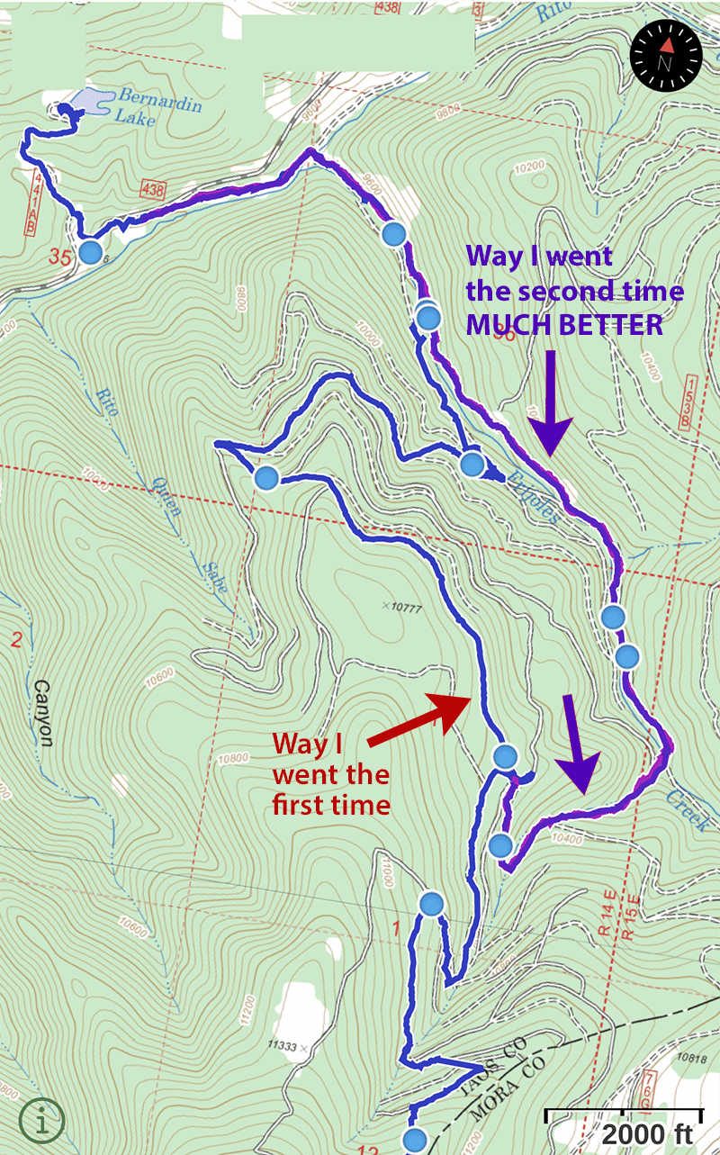 The purple line (and fushia line underneath it) is the way I found on the second visit. This is a lovely, easy trail. It’s well-worn, largely flat, and even has water within easy access the whole way. It’s even mostly under trees, so if you were going through here in bad weather or even a thunderstorm, you’d be well under the trees for pretty much the whole way.
The critical intersection is here. It’s a five-way intersection of the old logging roads, and that makes it real easy to find:
The purple line (and fushia line underneath it) is the way I found on the second visit. This is a lovely, easy trail. It’s well-worn, largely flat, and even has water within easy access the whole way. It’s even mostly under trees, so if you were going through here in bad weather or even a thunderstorm, you’d be well under the trees for pretty much the whole way.
The critical intersection is here. It’s a five-way intersection of the old logging roads, and that makes it real easy to find:
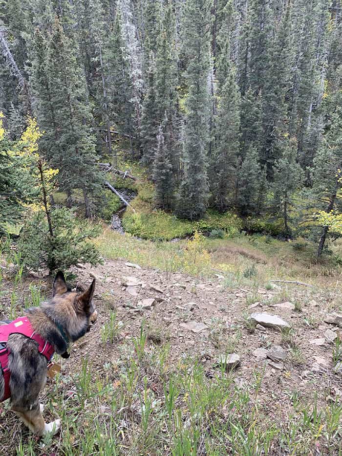
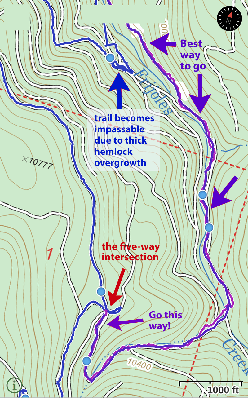 There are a few photos of the trail below. Also note that there are several workable places to camp at if you wanted, though the area past the Chili waters sign would be my preference. Also note that by the time you’ve come down and crossed Frijoles Creek, there are two tracks that run roughly parallel to each other and to Frijoles Creek. They both go in the same direction; they’re both nice wide, well-built, clear trail. The only difference is one is higher up and further from Frijoles Creek, while the other one is down closer to the creek.
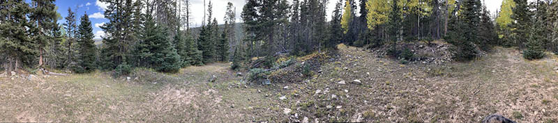
This is a panorama shot of the five-way intersection. Sorry… I couldn’t get all five tracks in the shot. But at least you’ll know somewhat what to expect when you get here.
There are a few photos of the trail below. Also note that there are several workable places to camp at if you wanted, though the area past the Chili waters sign would be my preference. Also note that by the time you’ve come down and crossed Frijoles Creek, there are two tracks that run roughly parallel to each other and to Frijoles Creek. They both go in the same direction; they’re both nice wide, well-built, clear trail. The only difference is one is higher up and further from Frijoles Creek, while the other one is down closer to the creek.
This is a panorama shot of the five-way intersection. Sorry… I couldn’t get all five tracks in the shot. But at least you’ll know somewhat what to expect when you get here.
 After you’ve taken the correct track at the 5-way intersection, you’ll be walking downhill gradually. You’ll cross this from the opposite direction shown in the photo (I took this walking up towards the intersection). This is the first water you’ll hit since you left the little trickle I mentioned while we were coming down from Cerro Vista, before we hit the 5-way intersection.
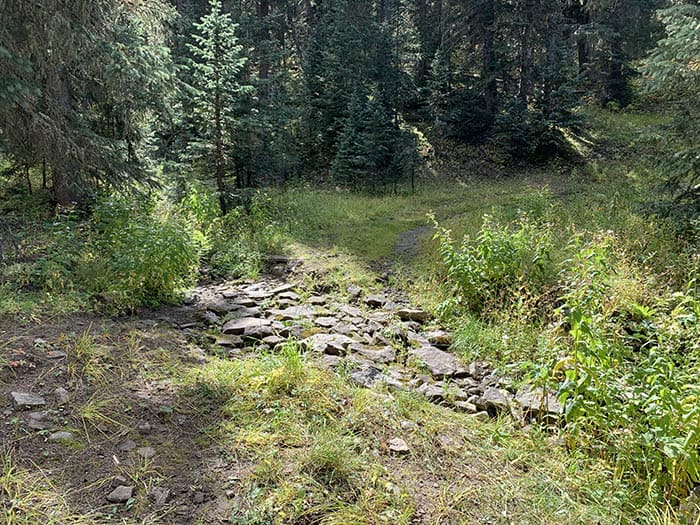 This is where you’ve come down from the five-way intersection and have just crossed a trickle of a creek that will merge into Frijoles Creek. There’s an old campsite here with a spot for a fire (please DON’T use it… we love our woods and we want to keep them. Skip the campfires!)
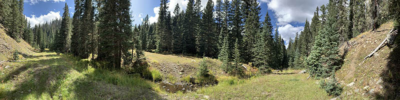 This is what the track is like after you’ve crossed the trickle and are heading down towards Bernardin Lake, flanking Frijoles Creek. Nice trail, right?
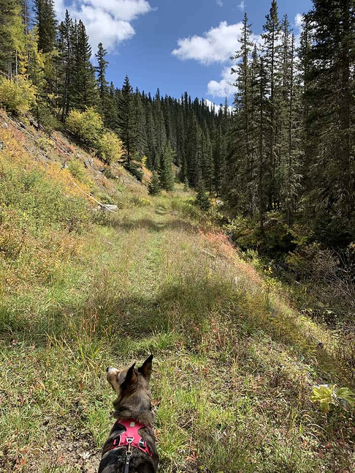 This is a view from the higher of the two tracks that run parallel to Frijoles Creek. Bit of a steep slope, but the creek is never very far away even from the higher track.
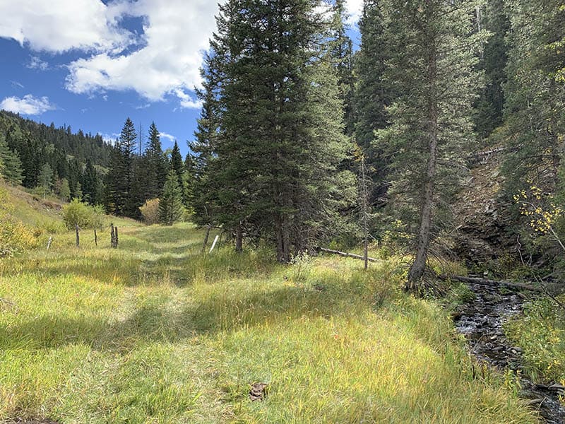
 This is the trail as you’re coming toward the chili waters sign. A nice, well-defined trail going through lush grasses alongside a creek.