

About the Santa Fe to Taos Trail
A thru-hike, a conservation project, and an opportunity for transformation
The Santa Fe to Taos Trail is more than an outdoor recreation project.
Part of the SF2T mission statement is “To give people a positive experience of the wild so they will take meaningful action to protect it.” If the thru-hike would ask that of others, it should do that itself. So part of the work of the thru-hike is to take meaningful action to protect the wild, especially along the route.
This takes several forms. Conservation, most obviously. The 2026 route of the thru-hike goes through a wilderness observation area. The thru-hike is partnering with New Mexico Wild to monitor and report on the conditions and beaver habitat in that area. A campsite monitoring program is being developed to ensure impacts to the high alpine lakes are minimized, and to take strategic and field-tested action when those impacts exceed acceptable use.
That’s a good start. But it’s only a start. Anyone who visits Pecos Baldy Lake and walks north will notice how many trees have died. This is bark beetle die off. As temperatures have risen, the beetles survive in higher, previously colder altitudes. The trees in these areas — already weakened by rising temperatures and reduced snowfall — have not built up defenses against the beetles, and so they are especially vulnerable.
Then, of course, there are the fires. The thru-hike goes through three burn scars (Jaroso, Calf Canyon/Hermit’s Peak, and the Sardinas Canyon fire). It skirts the Luna Fire scar. Fires are an essential part of New Mexico, but the fires we have been getting burn hotter. They don’t just clear underbrush, like the fires of earlier decades. They are “crown fires” that torch the largest trees.
Most of us are inclined to look away from these things. I would have us look to them. We should not avoid burn scars (after they’ve become safe). We should not abandon forests of dead trees. We need to see what’s happening. To see that, and to understand that, requires slowing down.
SF2T is an opportunity to slow down. The terrain it goes through supports this. It is also an opportunity to reconnect to ourselves and to nature, and potentially to something even larger. I would like people’s experience on trail to include reflection and stillness.
The trail is potentially a layering of connections — the connection between Taos and Santa Fe, between watersheds and creeks and rivers. A connection back to the history of these mountains and the cultures that have shaped them. There is an opportunity to be changed by the experiences we have as we travel between the plazas.
Isn’t that why we go? Even when we go “just” for recreation, we go to be changed. To be recreated.

Info sheet / “one-pager”
Click the image to get a printable PDF of the info sheet.

7 Reasons to Support the Santa Fe to Taos Thru-Hike
Click the image to get a printable PDF. Or view the Google docs version.
Key facts about the thru-hike
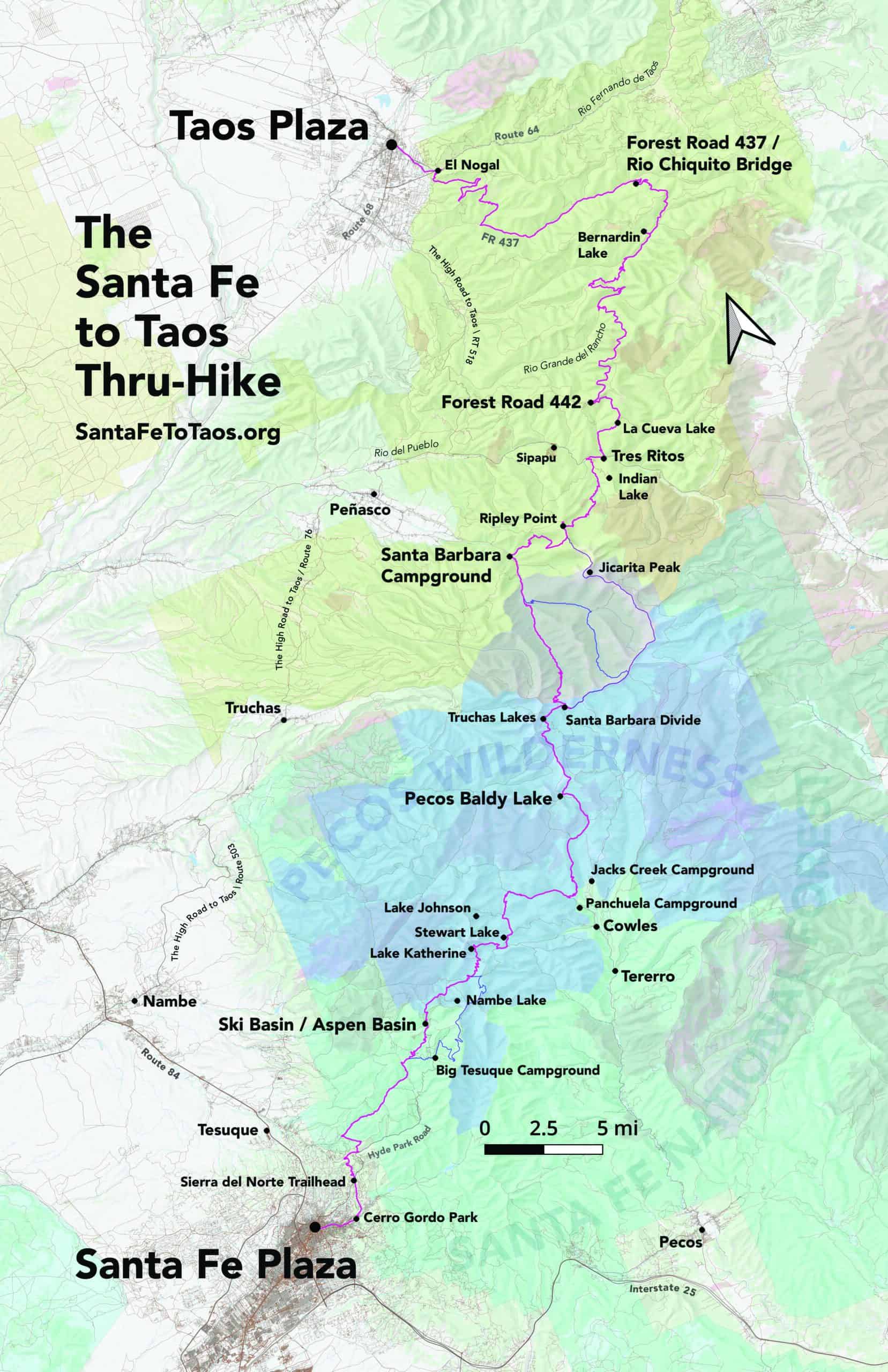
- The Santa Fe to Taos Thru-Hike goes from the Santa Fe Plaza over the Sangre de Cristo Mountains all the way to Taos Plaza… or vice versa.
- It is 132 miles long and spans four counties – Santa Fe, Rio Arriba, Mora, and Taos.
- It crosses the Santa Fe National Forest, Carson National Forest, and the Pecos Wilderness.
- There are six sections to the thru-hike, each roughly 20 miles long.
- About 65 people completed the full thru-hike in 2025. You can read some of those thru-hikers’ trip reports and see their photographs here.
- Parking is available at the Santa Fe Airport for about $7-$8 a day. Albuquerque Sunport also has good long-term paid parking. Parking is available for free for SF2T members for up to two weeks (or a little more). You can also park overnight at the Scottish Rite Temple in Santa Fe, but it costs about $5 a day and you must get prior permission and they have blackout dates where you’ll have to move your car.
- The Blue Bus serves most of northern New Mexico, is free, and has two lines (the 200 and the 300) that travel between Santa Fe and Taos.
- Almost all of the route is on existing trails or forest roads, plus about 2,100 feet along state highways. The highway sections are about 1,500 feet along Route 518 near Sipapu, and about 400 feet along Route 585 (aka “The Bypass”) in Taos. The Route 518 and Route 585 stretches have ample shoulder to walk on and no tight curves where a driver could be surprised by a pedestrian. There is also an alternate route that I’ve documented in the text directions that avoids Route 64.
- Stay tuned for the new Section 5 route, that will cut about 12 miles of road walking off the route. There is also likely to be a change to Section 6 as well that will cut out another 5 miles of road walking. With those two route changes, the thru-hike will have only 15.5 miles of road walking, and all but 3.5 of those miles will be forest roads. So 11.5% of the route will be on roads. And again – these are very lightly traveled forest roads. Even with the current route, most thru-hikers see one or two vehicles at most for their entire time on the roads.
- Trail conditions along the route are reasonably good. More than 80% of the thru-hike is on frequently-traveled trails. What is not frequently-traveled trail is still passable, but you should expect some blowdown.
- The thru-hike doesn’t have to be done all at once. It can be done in day hikes and one to two-night overnights. Or you could do each of the six sections in about a weekend, so you could complete the thru-hike in one summer over a series of weekends.
- The route does not go through any tribal lands, private property, or protected areas that don’t already have an easement for hikers. The only section of the thru-hike that goes through an easement is the “Santa Fe River Corridor” section (0.75-miles) between Camino Pequeno to Armijo Park.
- Should there be a need to change the route, there are enough alternate routes available on existing trails that the thru-hike could still connect the Santa Fe and Taos Plazas. The question to ask isn’t if there’s a way from Santa Fe Plaza to Taos Plaza. The question to ask is what’s the most beautiful, “best” route to take?
- The route has 13 points that are possible exits or access points. This facilitates accessing the trail for day hikes and delivering supplies to thru-hikers. It also allows for access from emergency services.
- There is ample water along the route. 28% of the thru-hike goes along rills (streams 1-2 feet wide), creeks, and rivers. It passes right by 13 lakes and ponds. The longest distance on the thru-hike without access to water is 8.8 miles from FR 442 / Ojitos Maes Trail (#182) to FR 439 in Carson National Forest. Even in this stretch, there are a few seeps.
- Resupply is available at Sipapu Ski Resort on Route 518 or at the Santa Fe to Taos Thru-Hike Members’ resupply in Tres Ritos.
- The route is not designed or intended for mountain bikes.
- There is excellent trout fishing along the route.
- The route was first established in 2018 when Pam Neely went from the Santa Fe Ski Basin through to Taos Plaza.
- The Santa Fe to Taos Thru-Hike is a 501(c)3, founded in October, 2023.
Simple text description of the 2025 route
See the route page for more details, including links to GPX files and detailed, turn-by-turn directions for doing the thru-hike.
Section 1: Santa Fe Plaza to Santa Fe Ski Basin (19.5 miles)
- S1-1: Santa Fe Plaza to Patrick Smith Park. 1.4 miles.
- S1-2: Patrick Smith Park to Arroyo Polay Trailhead via Cerro Gordo Park. 1.2 miles.
- S1-3: Arroyo Polay Trailhead to Sierra del Norte Trailhead. 1.8 miles.
- S1-4: Sierra del Norte Trailhead to Little Tesuque Creek / Juan Trail (Trail 399). 3.4 miles.
- S1-5: Little Tesuque Creek / Juan Trail (399) to Winsor Trail (254). 1.8 miles.
- S1-6: Winsor Trail (254) / Juan Trail (399) intersection to Winsor Trail (254) / Chamisa Trail (183) intersection. 3.25 miles. Gaia map.
- S1-7: Winsor Trail (254) / Chamisa Trail (183) intersection to Winsor Trail (254) / Borrego Bear Wallow Trail (150) intersection. 1.84 miles.
- S1-8: Northeast corner of the Borrego Bear Wallow Triangle to Forest Road 102. 1.9 miles
- S1-9: Forest Road 102 to Winsor Trailhead at The Ski Basin. 2.9 miles
Section 2: Santa Fe Ski Basin to Pecos Baldy Lake (26.2 miles)
- S2-1: Ski Basin / Winsor (254) trailhead to “the Y”. 2.4 miles.
- S2-2: “The Y” to Puerto Nambe. 2.2 miles.
- S2-3: Puerto Nambe to Lake Katherine. 2.8 miles.
- S2-4: Lake Katherine to Winsor Ridge (271) / Skyline Trail (251) intersection. 3.6 miles.
- S2-5 Winsor Ridge (271) / Skyline Trail (251) intersection to Skyline Trail (251) / Cave Creek (288) intersection. 2.9 miles.
- S2-6: Cave Creek (288) / Skyline Trail (251) intersection to Cave Creek (288) Dockweiler Trail (259) intersection. 3.3 miles.
- S2-7 Dockweiler Trail (259) / Cave Creek Trail (288) intersection to Dockweiler field and rill. 4.1 miles.
- S2-8: Dockweiler field and rill to intersection of Dockweiler (259) and Jack’s Creek Trail (257). 2.5 miles.
- S2-9: Intersection of Dockweiler Trail (259) / Jack’s Creek Trail (257) to Pecos Baldy Lake. 2.6 miles.
- Alt route: Puerto Nambe to Spirit Lake to Winsor Creek / Winsor Trail
Section 3: Pecos Baldy Lake to Santa Barbara Campground (19.6 miles)
- S3-1: Pecos Baldy Lake to Intersection of Skyline (251) and Jose Vigil Trail (351). 2.8 miles.
- S3-2: Intersection of Skyline (251) and Jose Vigil Trail (351) to Truchas Lakes. 2.5 miles.
- S3-3: Truchas Lakes to Santa Barbara Divide. 2.4 miles.
- S3-4: Santa Barbara Divide to West Fork of Rio Santa Barbara. 5.4 miles.
- S3-5: West Fork Rio Santa Barbara to intersection of Middle Fork Trail (24) and West Fork Trail (25). 3.6 miles.
- S3-6: Intersection of Middle Fork Trail (24) and West Fork Trail (25) to Santa Barbara Campground free parking lot. 3.1 miles.
- Alternative route: Middle Fork Trail
- Alternative route: Jicarita Peak
Section 4: Santa Barbara Campground to FR 442 (18.7 miles)
- S4-1 Santa Barbara Campground free parking lot to intersection Indian Creek Trail (27) and Bear Mountain Trail (28). 2.1 miles.
- S4-2: Intersection of Indian Creek Trail (27) and Bear Mountain Trail (28) to intersection Indian Creek Trail (27) and Divide Trail (36). 2.6 miles.
- S4-3: Intersection Indian Creek Trail (27) and Divide Trail (36) to Los Esteros. 1.5 miles.
- S4-4: Los Esteros to intersection of Agua Piedra Creek, Trail 19A and Trail 22. 3.8 miles.
- S4-5: Trail 19a/22/Agua Piedra Creek to Agua Piedra Campground entrance. 1.9 miles.
- S4-6: Agua Piedra Campground bridge/entrance to La Cueva Canyon / Trail 492. 0.9 miles.
- S4-7: La Cueva Canyon / La Cueva Trail (492) to intersection of La Cueva Trail (492) and Ojitos Maes Trail (182). 1.7 miles.
- S4-8: Intersection of La Cueva Trail (492) and Ojitos Maes Trail (182) to intersection of Ojitos Maes Trail (182) and La Cueva 8. 1.4 miles.
- S4-9: Intersection of La Cueva 8 and Ojitos Maes Trail (182) to Forest Road 442. 2.7 miles.
Section 5: FR 442 to Rio Chiquito / FR 437 (26 miles)
- S5-1: FR 442 to the beginning of the burn. 4.73 miles.
- S5-2: Beginning of the burn on FR 442 to fr 439 / Rio Grande del Rancho. 4.2 miles.
- S5-3: FR 439 / Rio Grande del Rancho to the beginning of the Connector. 4.0 miles.
- S5-4: The beginning of the Connector to FR 438. 4.0 miles.
- S5-5: FR 438 / end of the Connector to Bernardin Lake. 2.4 miles.
- S5-6: Bernardin Lake to Puertocito (intersection of FR 438 and FR 478). 2.3 miles.
- S5-7: Puertocito to Rio Chiquito / Forest Road 437. 4.5 miles.
Section 6: Rio Chiquito / FR 437 to Taos Plaza (20 miles)
- S6-1: Rio Chiquito / FR 437 to Buena Suerte Canyon / FR 437. 2.3 miles.
- S6-2: Buena Suerte Canyon to Manzanita Canyon on FR 437. 3.0 miles.
- S6-3: S6-3 Manzanita Canyon to Drake Canyon Loop Trail (165) on FR 437. 2.2 miles.
- S6-4: Intersection of FR 437 and Drake Canyon Loop Trail (165) to intersection of Drake Canyon Loop Trail (165) and unnamed trail. 3.4 miles.
- S6-5 Intersection of Drake Canyon Loop Trail and unnamed trail to intersection of Ojitos Trail (166) and unnamed trail. 1.5 miles.
- S6-6 – Ojitos Trail (166) from intersection with unnamed trail to Ojitos Trail (166) and a different intersection with another unnamed trail. 4.1 miles
- S6-7 Ojitos Trail (166) / unnamed trail to El Nogal. 1.1 miles
- S6-8 El Nogal to The Taos Cow. 1.7 miles
- S6-9: The Taos Cow to Taos Plaza. 1.4 miles.
Contact
If you have any feedback, ideas, comments, etc about the thru-hike I would love to hear from you. Send me an email: contact@santafetotaos.org
