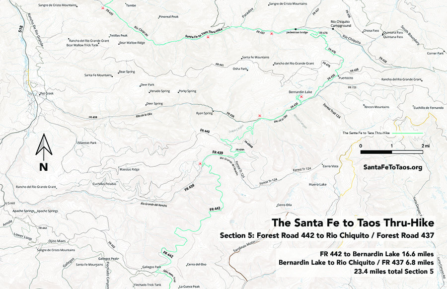
Section 5: FR 442 to Rio Chiquito / FR 437
- FR 442 to Bernardin Lake 16.6 miles
- Bernardin Lake to Rio Chiquito / FR 437 6.8 miles
23.4 miles total section 5
Gaia maps (digitized step-by-step tracks) of this section are here.
Or click the Gaia map screenshot below and it will expand to full browser window. You can then zoom to different parts of the image.

Or check out my new map for section 5.

You can download this map for printing. It’s available in legal size (8.5″ x 14″, 24 MB) and in tabloid size (11″ x 17″, 34 MB). Note that the campsites shown on the map above are not official campsites. But they are good places to put up a tent.
Text overview of Section 5
Follow the Gaia maps on your phone while you’re on the trail (Gaia works without cell reception) but here’s the text version of the walk just for extra information.
This is a pretty simple route. Start at the intersection of Trail 182 (Ojito Trail) and Forest road 442. Then you take a right and stay on 442 for 8.35 miles.
The warm access here is not ideal. There are a few seeps, but nothing very good. You will have good water at the end of the 8.35 miles when you hit the little creek called “Rio Grande del Rancho”. But that’s 8.35 miles without good water. This is the longest distance without water for the entire thru-hike. It’s better than going through the burn on the Colorado Trail (been there, done that, didn’t enjoy it. I’m not the only one.)
This area also goes through a burn for part of the distance. But most of it is shaded. I drove this in November of 2023 and marked waypoints where I was seeing seeps. Some of those seeps cuold probably be dug up a little, and maybe with a large stainless steel bowl, they could serve as really simple trick tanks. What we really need is a trick tank, but that’s a multi-department project probably.
But having been through the section 2 burn on the Colorado Trail, I can assure you this is going to be MUCH easier than that. There’s way more shade, and in monsoon season, if you really were thirsty, those seeps would get you from A to B. (Hint – bring a bandana or something you can make a crude water filter out of. It doesn’t have to be fancy – just some piece of cloth that will get the worst of the debris out of sketchy water. And then, of course, triple-treat your water before you drink it. I have a SteriPen Adventurer that is still going after seven years of use. The batteries are kind of a pain, but overall I’ve been really happy with it. I also carry water treatment tablets as a backup — and you definitely need a backup with the SteriPen. The batteries, as mentioned, can be a problem. The water treatment tablets have two phases – one to treat the water and the other to remove the iodine taste. I don’t mind the taste, so I dont even carry the second bottle.)

But back to the trail:
From 442 you’ll pick up FR 439 and 439A and basically (minus the curves back and forth) be northeast until you pick up Rita de la Olla Trail (#438). You take this left (still generally heading northeast until you get to the spur on the left that goes up to Bernardin Lake.

You don’t have to stop of Bernardin Lake (of course) but it’s nice. There are spots all along the creeks and off the road where you could camp if you wanted.
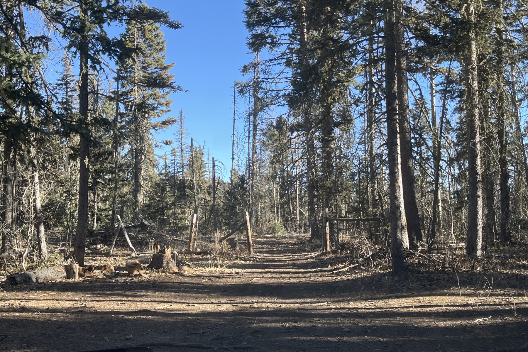
A note about the roads: They are very, VERY lightly traveled. It is more than quiet enough out here that you’ll hear a vehicle coming from a long way off (unless you’ve got headphones on, of course).
Do not even think about driving these roads without a four-wheel, high-carriage vehicle. Most of the road is okay, but when I was out here, I was very, very glad to have my Garmin inreach for comms, and enough water and food and blankets and lights/batteries to stay out overnight if I blew a tire. And I have very good tires, expressly chosen for largely-untraveled forest roads. Bring a hand saw, too, because you may come across a fallen tree or two. But the roads are passable. Just go slow.
From Benardin Lake you’ll get on Forest Road 438 and continue heading northeast. You’ll come to the fork of 438 and Forest Road 478 in 1.92 miles. Take the left on 478 and walk another 4.4 miles to Rio Chiquito.
All of this area has nice tree cover. There are a few big fields. There is no reliable water between Bernardin Lake and Rio Chiquito, with the exception of a beaver pond right next to the road near the Bernardin Lake side of 438. There was one seep that I walked by in 2018 that was doing well, but seeps are unreliable. Carry water, as always.
When you get to the bridge at Rio Chiquito, you have completed Section 5.

A word about going off trail
Newsflash: It’s dangerous. Once you’re off trail, you become MUCH much harder to find. Honestly, if you get in trouble and just stay on trail, search and rescue is going to a) check the parking lot to make sure you’re car is there and you didn’t just miscommunicate with the people who are wondering where you are and b) send a group a fast hikers down the main trails to sweep for you. c) send out more hikers to check all the trails in the area.
In other words, so long as you’re on trail, they’re going to find you. It could take a day or two, but they will probably find you.
Off trail? Maybe not.
That said, IF:
- You have good navigation skills
- You have at least two forms of navigation (a gps or your phone with downloaded maps and a printed map, for instance… and a way to keep your electronic navigation charged. Extra credit if you bring a super-simple little compass, even if its just an ounce or so.)
- Someone responsible knows where you are and when you are due back
- You have a communication device like a Garmin InReach Mini that would allow you to communicate with them if you got in trouble
- You have ample water, food, and shelter to stay the night if you needed to
it is possible to go off trail. You won’t die. It’s ground – you can walk on it.
I say this extreme caution because I hear far, far too many stories of people doing outrageously dumb stuff in the woods. And it happens. It especially happens if you’re tired or dehydrated, or (much worse scenario) if you’re going into hypothermia or heat stroke. People make dumb decisions sometimes. I have made dumb decisions sometimes. Even if you stay on trail, you need to be prepared enough to be okay if you do something dumb, AND if something bad/weird happens. Have backup gear and a plan at all times. Like… say you make a dumb decision to not carry enough water and then, say, your boot shoe lace breaks and you have to slow way, way down, thus ending up without water for an hour or two longer than you expected. Can you handle being dehydrated for a couple of hours? Or will it already be so hot, and you’ll be so tired, and your pack will be so heavy, that you’ll be in trouble?
No one can answer these questions but you, and only you in the moment can answer them. But just going off trail, in a sense, qualifies as one “dumb” thing, or one thing going wrong. It puts you that much closer to being in trouble. Serious, potentially life-threatening trouble. Especially if you’re in adverse weather, whether that’s heat or cold.
So sure, you can go off trail. I go off trail. Just be aware of what you’re doing. Because if even one little thing goes wrong off trail (you twist an ankle, say), you’re immediatel in trouble. You wont have the buffer of two things going wrong before you’re in trouble.
When I was on a technical rigging search and rescue team, our trainer at one point was talking about safety, and about all the 1,001 things a technical rigging team needs to be doing to keep everyone safe. But human error happens. It’s going to happen. You can absolutely strive for excellence and be laser-focused on eliminating every safety failure, but they are going to happen. If you’re on a good team, you’ll have so many other safety catches going that those other safety best-practices will almost always fix or overcome the one safety error. All of your systems have a backup.
What’s dangerous is when two failures line up in just the wrong way. That’s when people get hurt. And when you are off trail, you have already handed over one of your safety catches – that if you get in trouble, at least you’re on trail, and you are relatively easy to find (“relatively” being the operative word here). Once off trail, you are no longer easy to find.
Have I banged on about this long enough? I hope so.
So now that I have done that, let me talk about a shortcut I am interested in.
As mentioned above, the 8+ mile walk along FR 442 has no good water. But there is potentially a shortcut.
This is the USGS Topo overlay from Gaia.

It shows a path off 442 near Fowler Canyon that goes down to … Fowler Canyon. The end of that trail is 0.93 miles from FR 439 and Rio Grande Del Rancho. It would make a nice cut through to get to water much faster than going all the way around on 442.
You would have only about 3.3 miles without access to water, instead of 8.3.
But you’d be going off trail.

I will be trying this out as soon as the snow melts in spring. It’s definitely not a long distance – less than a mile – but it’s steep. I will probably end up walking in a switchback pattern. But I think it’s worth a look. This is the sort of shortcut that it would be great to have a) permission to establish and b) a team of people to help with clearing a trail, even if it was just a crude trail.
It would make for a nice section of the thru-hike, too. There’s good tree cover along FR 439. Wherever possible I try to run the thru-hike’s route along water, and FR 439 would have you alongside a reliable stream for almost 4.5 miles.
Here’s a view of the Fowler Canyon area via satellite:

If you click on that image, it will blow up full screen.
See all the little lines through the forests? Those are all over this part of Carson. They’re old logging roads, and sometimes still used by hunters and people who cut wood (with permits, of course). So there may already be a trail through.
Also notice the trail in the lower right corner of that photo. That’s trail 442, which runs roughly parallel to FR 442. Ideally, I’d be bringing you all along trail 442, and there would be a little cut through to get to FS 442, then you could duck on to that existing Fowler Canyon Trail, and then follow a logging trail down Fowler Canyon until you got safely to FR 439.
We’ll see. This section of the trail needs the most work of the thru-hike. But there’s no question you can go through. The question is what’s the best way through.

