Section 2 – Santa Fe Ski Basin to Pecos Baldy Lake
- Ski Basin to Lake Katherine
- Lake Katherine to Cave Creek/Dockweiler Trail
- Cave Creek/Dockweiler Trail to Jack’s Creek Creek
- Jack’s Creek Creek to Pecos Baldy Lake
20 miles total section 2
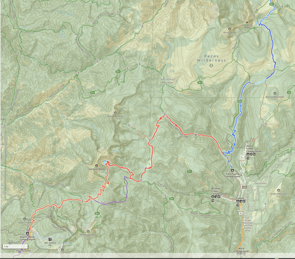
Gaia maps (digitized step-by-step tracks) of this section are here.
Or click the Gaia map screenshot below and it will expand to full browser window. You can then zoom to different parts of the image.
Or check out my new map for section 2:
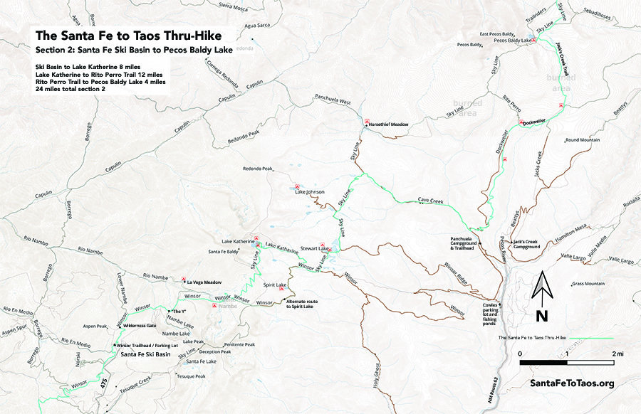
You can download this map for printing. It’s available in legal size (8.5″ x 14″, 14MB) and in tabloid size (11″ x 17″, 34MB).
Note that the campsites shown on the map above are not official campsites. But they are good places to put up a tent.
Overview of Section 2
Follow the Gaia maps on your phone while you’re on the trail (Gaia works without cell reception) but here’s the text version of the walk just for extra information.
- You start at the Aspen Basin Trailhead for Winsor Trail 254. There’s good water here, “parking lot style” campsites, bathrooms, and a large parking lot, plus all the amenities for the Ski area (though I don’t know if the Ski facilities are open during the summer.). This is the last water for about an hour.
- You’ll go up a series of switchbacks until you get to the Wilderness Gate. Sign in if you want.
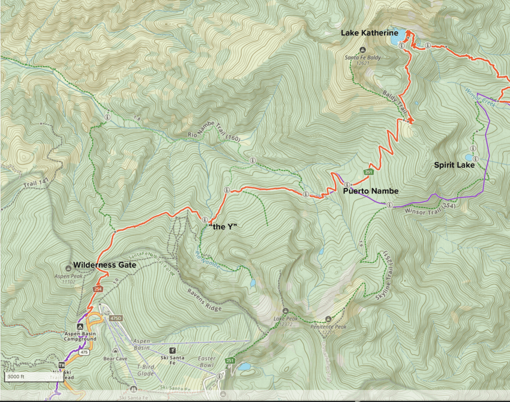
- Continue on Winsor Trail towards “the Y”. This is about half an hour walk. You’ll see a fair amount of people and dogs – this section of trail gets some of the heaviest use in all of the Santa Fe National Forest. When you get to the Y, keep going straight across Nambe Creek/River. There’s a crude bridge. The next water you’ll have access to is about 30-45 mins away.
- Continue along Winsor Trail. You’ll cross two or three small streams, then begin the climb up to Puerto Nambe.
- Puerto Nambe is an enormous field. Ample camping sites, but no water. Expect cows.
- You can continue left towards Baldy and Lake Katherine, or you can go right and go to Spirit Lake. The best way to go is via Baldy and Lake Katherine, but I offer the Spirit Lake route just in case there’s bad weather. As you head towards Katherine and Baldy you will go up some long switchbacks. It’s a climb. And then, when you get to the top, you’re somewhat exposed. Because lightning really is a thing to be aware of here, if the forecast is for thunderstorms, consider the Spirit Lake route.
- Once you’re up on the saddle, the way to Katherine is to go basically straight until you pick up yet another set of switchbacks that will basically bring you down from the saddle, then swing you left towards the lake. Once you’re off the switchbacks there’s shade and trees.
- Continue on until you get to Lake Katherine. It’s big, and gorgeous, and there are fish in it. You may have to look around for a quiet camp site. Sometimes during the high season Katherine gets a lot of visitors. Try the far side of the lake.
- From Katherine you’ll go down. Many GPS maps are incorrect in this “back side” of Katherine, but the trail is clear and well-worn. There are several water sources on the way down, and you’ll hit a large creek (large for New Mexico) when you get to the next trail.
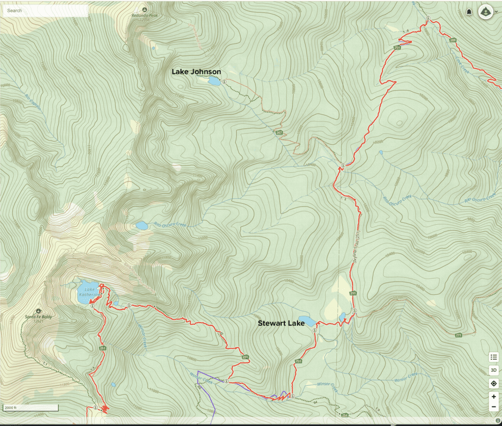
- Take the left towards Stewart Lake. You’ll pass it on your left in about 45 minutes or so. There’s another smaller pond just past it. There is ideal camping around here, but it’s wel-traveled, so expect some company.
- As you get just past the pond, you’ll take another left to follow Skyline Trail. From here, the trail gets less-traveled. You’ll continue for about 90 minutes or so until you get to Cave Creek. If you want, and need a camping site, take a left about halfway to Cave Creek and head up to Lake Johnson for the night. It’s only about a mile up.
- At Cave Creek, take a right to go down towards Panchuela Campground. You’ll have Cave Creek next to you the whole way down, and you can stop and check out the caves if you like.
- A bit past the caves you’ll run into Panchuela Creek, then go right alongside Panchuela for a bit.
- When you come to Trail 259, Dockweiler Trail, take the sharp left and continue on up the hill. It is a climb. Rest alongside Panchuela first and get some water treated if you want. You’ll be without access to water for about 90 minutes or so.
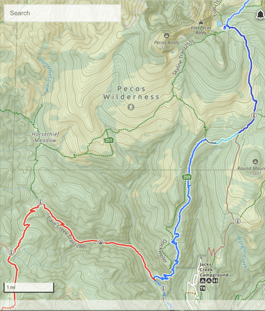
- After you’ve completed the rather long up Dockweiler, it will eventually somewhat flatten out and you’ll be among aspens and fields. This is not frequently-travelled trail, and there are a few fallen logs, but it’s nothing too hard. There are a couple of seeps and one excellent little stream to get water form. That little stream is in a nice field if you want to stay for the night.
- As you continue up Dockweiler, you’ll eventually get to where it intersects with Rito Perro Trail. This is a nice big field with a great view of Round Mountain.
- Continue on Dockweiler towards Jack’s Creek Creek. There’s a good water source about 10 minutes from the intersection with Rito Perro. There’s also a pond before you get to Jack’s Creek, and then, of course, the creek itself.
- Continue on Trail 257 towards Pecos Baldy Lake. You will go through part of the burn. This is from a fire in about 2016. There is at least one pond along the way, and you’ll be next to a stream for about 1/3 of the way to Pecos Baldy.
- As you go along 257, you’ll cross two more streams and then start a gentle climb to the lake. You’ll see Pecos Baldy rise up from behind the lake.
- There are good campsites all around the lake. Consider getting under trees if you can. The weather can be interesting up there. Also – if you stay overnight – get out and look at the stars. From this altitude, they’re amazing.
- If you have the energy, also climb up to the summit of Pecos Baldy. It’s a mad view.
Spirit Lake
Spirit Lake is much smaller and shallower and less dramatic than Lake Katherine is. But you can take this alternate route if you want, especially if the weather is bad and you don't want to go over the saddle near Baldy. Lightning is a thing in New Mexico, especially at altitude, and the saddle is definitely at altitude.
