horizontal summary map 121824-for-summary120second-video
horizontal summary map 121924-for-summary120second-video-sixsections
horiz-summary-map-121924-for-summary120sec-video-section1-highlight
horiz-summary-map-121924-for-summary120sec-video-section2-highlight
horiz-summary-map-121924-for-summary120sec-video-section3-highlight
horiz-summary-map-121924-for-summary120sec0video-section4-highlight
horiz-summary-map-121924-for-summary120sec-video-section5-highlight
horiz-summary-map-121924-for-summary120sec-video-section6-highlight
horiz-summary-map-121924-for-summary120second-video-2wks10miles
horiz-summary-map-121924-for-summary120second-video-seriesofdayhikes
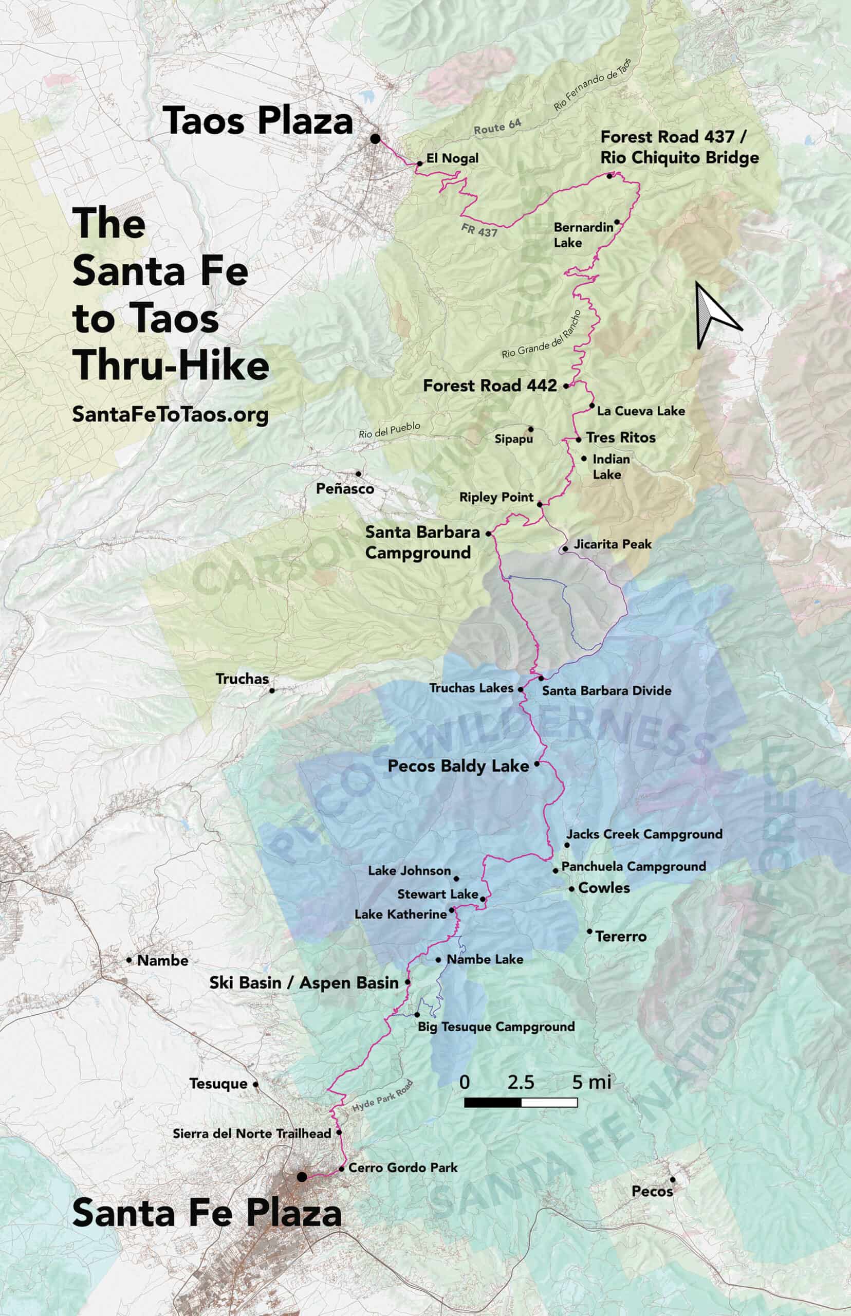
The Santa Fe to Taos Thru-Hike goes from the Santa Fe Plaza all the way to Taos Plaza over the Sangre de Cristo Mountains of northern New Mexico. It is 132 miles long, spans four counties – Santa Fe, Rio Arriba, Mora, and Taos – and crosses the Santa Fe National Forest, The Pecos Wilderness, and Carson National Forest. The full route has 35,000 feet of cumulative ascent and descent, as both plazas are at 7,000 feet elevation.
The route is over ten years in the making, scouted and refined by Pam Neely beginning around 2014, and then first completed as a thru-hike in 2018. It has been refined several times to optimize safety and access to water. It is still being refined, with a new alternate route to be announced later this year.
Congratulations to everyone who finished the thru-hike in 2025! If you finished the thru-hike, but:
Haven’t sent me your trip report and/or
Would like to be included on this pag e.
Send me an email (contact@santafetotaos.org) or use the contact page . There’s a free gift in it for you…
Maps and route
See Gaia GPS maps documenting every step of the thru-hike. Or see the route page and individual section pages for details on the route and turn-by-turn directions for the route.
Presentation at the Los Alamos Mountaineers monthly meeting at the Los Alamos Nature Center Planetarium, Tuesday, October 28th
Huge thanks to the Mountaineers and the Nature Center for this opportunity.
VIDEO
Plaza to Plaza in 52 photographs
Each photograph is from one of the 50 subsections that make up the route.
S1-1 Santa Fe River Trail
S1-2 Santa Fe River Corridor
S1-3 Chasing Dreams beyond Arroyo Polay Trailhead
View from Little Tesuque Trail, Section 1-4
oaks in Juan Canyon, Section 1-5
S1-6 Winsor Trail and Big Tesuque Creek
Section 1-7 Along Winsor Trail
Section 1-8 Field near Winsor / Borrego intersection
S1-9 Going up Winsor Trail
S2-1 Be Here Now sign off Winsor Trail
Section 2-2 Climbing toward Puerto Nambe on Winsor Trail
Section S2-3 View of Truchas Peaks from the saddle en route to Lake Katherine
S2-5 New views along Skyline Trail
S2-6 Coming down Cave Creek Trail
S2-7 End of the climb up Dockweiler Trail
2-8 Dockweiler Trail toward Rito Perro
S3-4 Santa Barbara Divide
S3-5 Middle Fork Trail with Truchas Peaks
S4-2 Trail up to Ripley Point
S4-3 Jicarita Peak from Ripley Point
S4-6 Interpretive trail off Rt 518
S4-8 view from La Cueva Cutoff Trail
s4-9 View from Forest Road 442
s5-1 View from Forest Road 442 before burn
s5-2 View from Forest Road 442 after burn
S5-3 intersection of Forest Road 440 and the connector
S5-4 Forest track along the connector
S6-4 Entrance to Drake Canyon
S6-5 view of Taos Mountains from unnamed trail
S6-7 view from Kit Carson Road


 of Section 6 of the Plaza to Plaza Thru-Hike")


