Paul Davis, Santa Fe, NM
Paul did the thru-hike northbound in September.
back to the main 2025 SF2T Finishers page
When I saw the first article in the SF New Mexican about the SF2T hike, I was immediately taken with the plaza to plaza idea. Last year (2024) I did a solo hike in the Pecos that was supposed to be the whole of the Skyline Trail, but closure of the SE section had led me to look for alternatives to make up the distance. I had considered hiking up out of Santa Fe, but ultimately didn’t do that. Then SF2T appeared on my radar with a preplanned “walk up out of the city” and I knew I should do it.
Based on recent day hikes with my wife, I expected to only backpack 16 or 17 miles a day, so my initial plan for day one was to reach Big Tesuque campground. I took the Blue Bus (route 290) to the Plaza from my village of Galisteo, and at a few minutes after 7 am, started the walk up Alameda. I was so impressed and delighted by the route out of town, although a combination of inattention and hubris led me to miss the turn up into Cerro Gordo Park. Despite quite a lot of hiking around Santa Fe, almost all the way up to Big Tesuque was new to me, and I was particularly excited to finally use one of the “connectors” between the Dale Ball system and the Winsor trail. Dropping down to Little Tesuque was surprisingly steep, but also thrilling to hear the rushing water. I eventually reached Big Tesuque campground by 2:40 pm, way ahead of “schedule”, and decided to continue on up to the Aspen Vista trail, which wasn’t new to me. In the end, I got a significant way up to Tesuque Peak before setting up my tent at about 6 pm. The guidebook very accurately mentions “a few camping spots” – do not delay too much, because once you pass through that area, the trail starts climbing again and there is really nowhere to camp.
Day two began with a relatively quick “finish” up Tesuque Peak, with the Aspen Vista “trail” still feeling remarkably steep. I excitedly made the left onto the very beginning of the Skyline Trail, and started the crossing of Lake Peak, Deception Peak and Penitente, none of which I had been over before. Lake and Penitente were much easier than I thought from the way the trail looked, but the sidepath around Deception had me repeating “pay complete attention” over and over. A single misstep here could be very bad, and I was very glad to have poles for extra balance. The view from the top of Penitente was absolutely magnificent — the whole of the Pecos watershed, a huge section of the Rio Grande rift valley, Jemez to the west. I don’t recall such a view from Santa Fe Baldy, even though its summit is probably only 1/3 mile as the crow flies from Penitente. My memory is not what it once was, though! I whooped and hollered as I began the descent to down to Puerto Nambe, and found myself back on some of the trails I hike last summer as I wandered by Spirit and Stewart Lakes. The climb up the Dockweiler trail was initially challenging, but I settled into a groove and eventually reached the section that is much flatter. I had considered camping in the field at the intersection with the Rito Perro trail, but really didn’t see a good spot, and so I descended to the intersection with Jacks Creek Trail, and ended up camping at the supposedly “always busy” area by the creek. There was nobody else there, of course.
Day three began with a march up to Pecos Baldy lake. My memory of the Skyline trail from the previous year began to mess with me on the way to Truchas Lakes. I recalled getting from Truchas to Pecos Baldy very quickly that year, and was getting pretty irritated with the endless sections and climbs that I had forgotten. Eventually I made it to Truchas Lake, and felt much better. I took the shortcut up to the Santa Barbara Divide, which was a bit foggy/cloudy and then a light hail began. This spot is probably the most alpine on the whole SF2T route, and even with Truchas Peak and Chimayosus in the clouds still felt magnificent as I started down the very exposed drop along the west fork trail. Despite the initial steep switchbacks, this trail soon settles into very gentle downhill grade, and the 12 miles to the campground entrance ultimately felt like it went on forever. Some of that was another memory — a loop hike with my wife that started and ended at the campground entrance via Jicarita Peak, and also involved a “death march” trudge down the last few miles of the Santa Barbara trail. Eventually, I entered the campground, took a short break and pressed on to get at least some of the climb up Indian Creek trail done. I had planned to camp in the meadow that is less than a mile from the trail start, but I don’t like “long walks” to get water and the campsite didn’t seem that great, so I walked on the 1/4 mile or less to the creek crossing. The land had become much steeper, fairly impractical for camping, and then the skies opened up with heavy, heavy rain. I managed to find a tiny spot between two trees that was just large enough and flat enough to put up my tent (in the rain). Stuff didn’t get too wet despite the rain, and it eased up after 20 minutes or so allowing me to make dinner relatively easily. Then it picked up again, and that discouraged me from hanging my pack from a tree for the night, instead stuffing it into a tree-covered spot some distance from the tent.
Day four began after a mostly dry night, though my tent was still wet from the rain the day before. I loaded up my pack and went to put it on, puzzled by why my left arm wouldn’t engage with the strap. Closer inspection revealed that the strap had been eaten through by some critters. Panic set in — or was it relief — would I need to bail out and hike back down to the SB campground and get a ride? Some more thinking let me notice that the shoulder lift straps on my pack had a lot of excess length so I pulled out my knife, cut some off and managed to do a workable repair by tying a knot with the short stub that the chipmunk or whatever had left me. The strap was a lot tighter though, and after donning the pack, I realized that the bastard creatures had actually taken the chest strap completely. I had a long piece of webbing/strapping on a solar panel, but I decided that since I would hit the resupply in Tres Ritos later, I would wait till I got there before attempting a better repair.
I continued the long march up to Ripley Point, which was actually easier than I expected, having previously approached it by turning left at the trail junction and gone up some logging roads. Indian Creek Trail itself was not as steep, and glistened in the early morning sun, rain drops still clinging to leaves and moss as I moved higher. Despite not having walked that way before, I was pretty sure I knew where I would come up, because on our day hike last year, my wife and I met a couple of hikers who were coming up that trail. Sure enough, I hit the inexplicable river of downed but uncut trees, and turned left to reach Ripley Point. A much steeper descent to the next trail junction followed, and from that point on I was going to on trails and in an area I had never hiked before. A long and not too technical descent brought me down Agua Piedra campground, and my first conversation with anyone in 4 days. I got a bit confused about where I supposed to go to reduce the amount of highway walking on the way to Tres Ritos, but it worked out in the end, and before long I was standing in the resupply storage unit. I was moving much faster than I had anticipated, so really didn’t need most of the food I had shipped to Pam ahead of time. I sorted through my meal choices, picked my 3 top and left the rest for others who may pass through. Then I searched to see if there was any webbing for a pack repair, and on not finding any, proceeded to remove the one on my solar panel. I cut it up to do a longer, better fitting repair to the shoulder strap and then fashioned a functional chest strap. Ahhhh … much better. I was suprised that I didn’t really want to indulge in any of the soda or chocolate in the resupply, but did eat some lunch, and set off feeling a bit renewed and certainly more comfortable.
The initial climb out of Tres Ritos wasn’t too bad, but then I turned right at the bench and faced the most ridiculous climb of the whole hike. Still, I had a rhythm now, and eventually things levelled out at the lake which as Pam noted “you may not find that impressive”. It started raining lightly, so I threw on some goretex and a hat … and then it stopped. A relatively easy, mostly level walk brought me to Gallegos Park on FR442. It was clearly used by many as a campground – there was even a blue tarp-covered pile of fire wood and a disconnected tree-mounted fluorescent light! The last of the evening sun was very welcome as I ate dinner staring south at a lovely view. I spent a bit of time thinking about my plan for the next two days, and figured that although I could reach Taos by then, I’d be too late for the bus home which was a central part of my conception of the hike. So I planned to have a couple of “easy” days (17-18 miles), and hike down into Taos on the morning of the 7th day in time for the 2:50pm bus to Santa Fe.
Day five started surprisingly cold, and my tent was very wet with dew/condensation. I had put on a couple of extra layers of clothing, and even gloves, before setting off down FR442. After the burn section, it was a mostly downhill walk, occasionally steep. A father and (maybe) son were out with a chainsaw to clear a tree that had fallen across the road. It was odd hearing the sound of machinery after several days of almost zero man-made sound. I eventually reached the intersection with the next forest road and stopped to dry out my damp tent. Then began a lovely, easy stroll up through sunny meadows, and then a flat meander to find “The Connector”. I don’t know how long it took Pam to find this section of the route, but it is genius. Other than potential confusion when trying to find the start of it, it is generally a very clear and easy to follow section that reminded me of an overgrown rail-trail more than anything else. Of course, the blue tape markers that someone recently added don’t hurt. 🙂 Rarely steep it wound its way down to the next forest road for several miles. A “Dead End” sign stood in the woods at the lower end. A day hiker was approaching from the left as I started out up towards Bernadin Lake — we talked briefly but it was soon clear that I was moving much faster than him. Sooner than I expected, I reached the “turn” for the lake, which someone has flagged with orange tape (handy!). It was a bit of a stiff, if short, climb up to the lake, which was a bit underwhelming. I did manage to take a quick dip which was refreshing though a bit grungy. I had thought I would camp by the lake, but it really seemed to have little to recommend it, so I dropped back down to the beaver pond, reversed by a couple hundred yards and found a nice spot on the final part of the “road”. Filtering water from a beaver pond felt a bit weird, given that the primary risk is literally called “beaver fever”, but it was also amazing to admire their handiwork.
Day six began as the previous two days had: hiking on forest roads. I really didn’t mind this – the contrast with the often technical trails south of Ripley Point was nice and the grades generally easy. I once again reached the next intersection, stopped to dry out my condensation-laden tent and use Rio Chiquito to rinse out some socks and a t-shirt so I wouldn’t be too pungent on the bus the next day. Then began the long (7.3) mile stroll down the forest road in the Rio Chiquito valley. It was nothing short of delightful … initially sun-filled meadows, then later the forest creeping in and out, and a gradually drying up of the landscape (especially on the south facing slope). Except of course for all the beaver ponds along the creek creating a riparian haven on the left side of the road for miles. It was really one of the loveliest valleys I’ve walked or cycled in, and I’d like to go back there sometime and camp out in our van. Eventually I reached the turn for Drake’s Canyon and took a very relaxed lunch by the creek in the rather unpleasant parking/camping spot opposite the turn. Trash and the generally nasty results of vehicles were all too apparent, but I lingered for longer than usual, knowing that the next section would be my last climb of the route. It started out very pleasantly – still shaded despite the mid-afternoon sun, and not too steep. Eventually, the grade picked up, and I became endlessly frustrated by the sense that I was almost at the top, a sense that was always wrong.
After what felt like a bit too long, I came across another walker relaxing by the side of the trail. He was just out for a loop day hike, but was really excited by the idea of SF2T when I showed him the book. We talked for a good long while, and then I moved on just 100 yards or so to the intersection that marked the top of Drake Canyon, which was also a perfect campsite when you really don’t care about being “on trail”. The other hiker strolled by later and we talked some more, and then I settled in to make dinner and enjoy my final night on the trail. It was marred only by realizing that I could hear traffic noise from Taos, though that did die down as the night deepened.
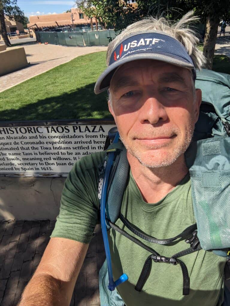
Day seven saw me get up and forego my usual breakfast since I wanted to be hungry when I got into Taos. I started the long, long downhill, often a bit frustrated that it was harder to go faster than I might have done going up it. The landscape grew ever drier as I descended, and after a while, I was back in the juniper/pinon rocky desert conditions that accompanied me as I left Santa Fe. I opted to take Pam’s alternate route to skip the highway, which was fine in every way (though I was glad to be able to use GPS plus my map to check precisely where I needed to be). I finally reached the road and wandered into the edge of Taos, struck by the curious mixture of wealth and poverty, new money and old families that was just as much a part of this place as Truchas or Lake Peak were. I got a tour of an old adobe church, mostly because the couple who have maintained it for 25 years happened to be working on it. You can still read the names of the original builders inked into the wooden ceiling! Finally, the Taos Cow came into sight, and I enjoyed a double scoop before moving onto the final, less pleasant walk into town. A few fun gallery-fronts later and I was in the Taos plaza, hike done!
I ate lunch at La Cueva and then wandered slowly down the main drag in Taos to the admin building. I stopped in at the Re-Threads thrift store – picked up a couple of dresses for my wife! – and found myself lounging around on the grass under tree shade, waiting an hour or more for the 300 bus that would take me to Santa Fe. I hadn’t had that feeling since I was a young adult travelling in Europe for the first time. The bus was right on time, though the air conditioning was functioning as a heater. Had a nice chat with someone with a bunch of different businesses in northern NM who was “placed” on the bus to go pick up his truck (“most embarrassing thing my wife ever did to me”). I changed busses in Espanola to be sure to make the 290 back to Galisteo – curiously, a later departing bus gets to the right part of SF earlier. A short wait on Alameda, my bus arrived with the driver visibly laughing to see me again (I never did tell him where I’d been). 35 minutes later, I stepped off the bus in my village, walked the 1/4 mile home, and SF2T was over.