Both forests are in Stage 2 Fire Restrictions
Gas canister / Jetboil-style stoves are still allowed, but only if they use liquid petroleum or LPG, can be turned on and off, and are used in an area cleared of overhead and surrounding flammable materials within 3 feet of the device.
Absolutely no campfires in the woods right now.
If you see someone with a campfire, respectfully ask them to put it out. There are other important points in both orders; please read them. Fireworks are never allowed in national forests.
If you come to the Santa Fe to Taos Trail, please come as a steward.
We are not here just to pass through and take from this place, or any place. We are here to care for it, all of it: the lands and waters and wildlife, the communities connected to them, and the trail infrastructure that makes hikes possible.
Thru-hiking is not inherently extractive, but it can become extractive when hikers increase the wear and tear on all the things that make their journey possible without contributing to their care.
That is not said to make anyone feel bad or guilty. It is not necessarily to say, “don’t come here.”
It is said because hikers have responsibilities. We all do.
It is time for more hikers to shift from speeding through and checking trails off their lists to caring for the places, people, and systems that make their journeys possible. Many already do this.
The simplest way to make this shift is to start saying “thank you” more often.
Start saying it when and how you might not have before. Like to the ground you slept on, or the trees you hung your hammock from. To the breeze that cools you, and the sun that warms you. To the water sources that sustain you.
Just saying “thank you” changes the interaction. It changes us, too.
Great things can come from small beginnings.
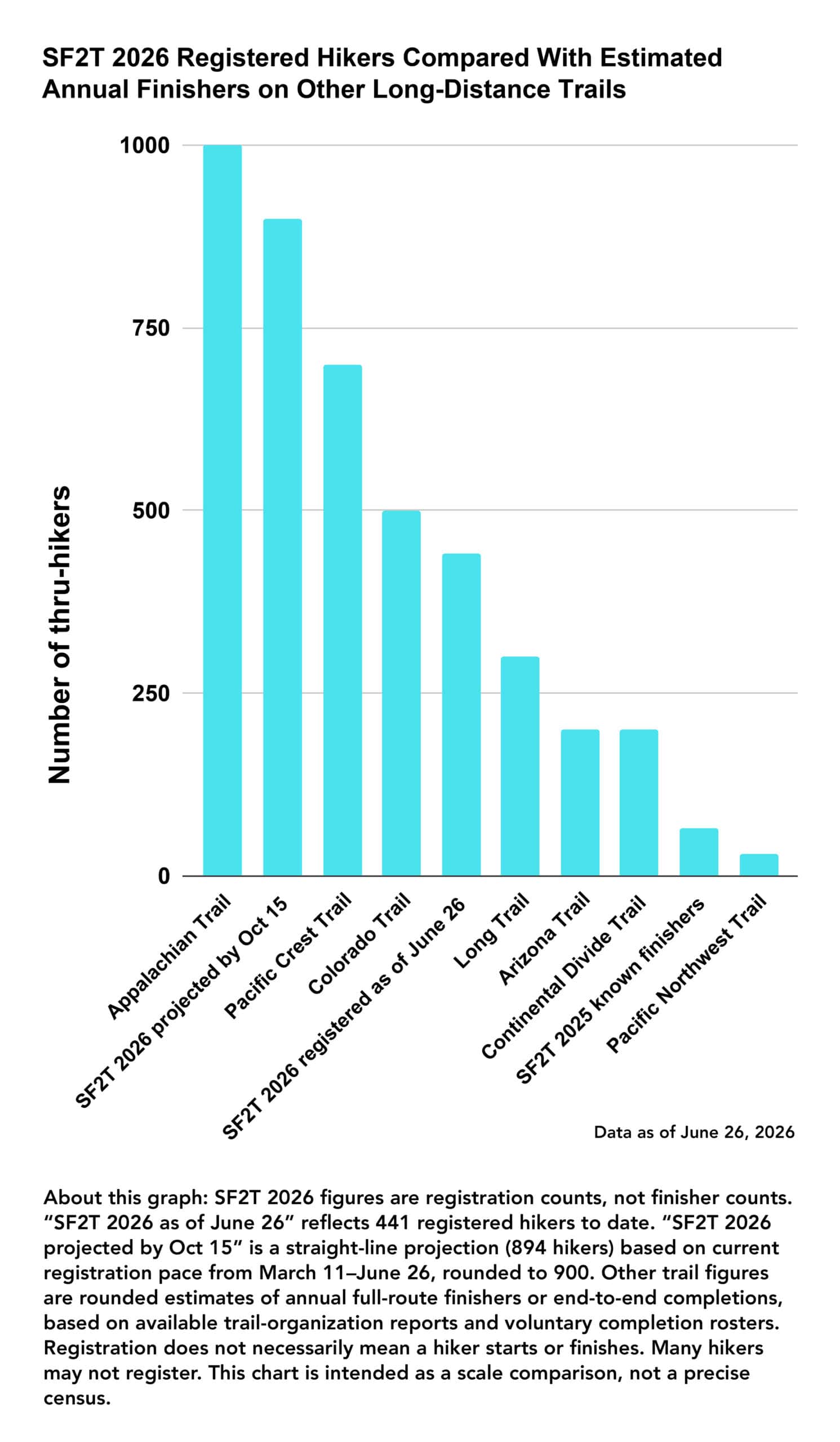
The Santa Fe to Taos Trail is undergoing a massive increase in traffic. We will see 10x as many hikers as last year – more hikers than do the Colorado Trail every year, and two to three times as many hikers as do the Continental Divide Trail every year.


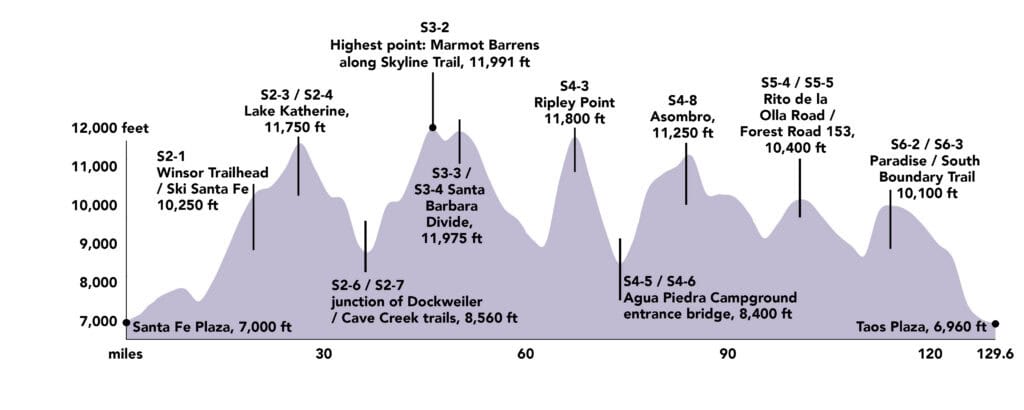
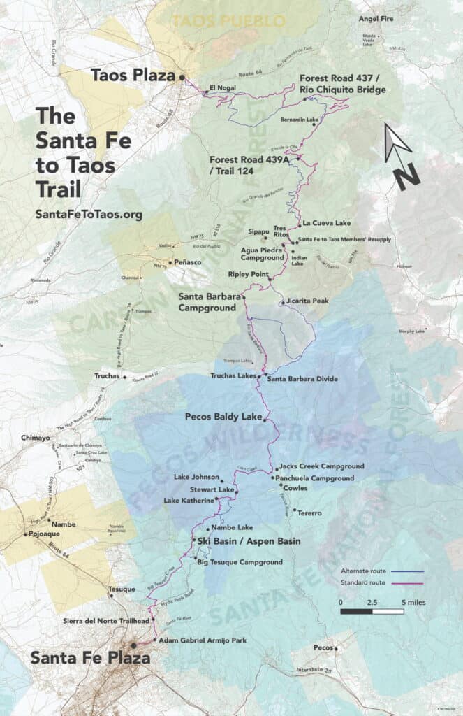
The Santa Fe to Taos Trail goes from the Santa Fe Plaza to Taos Plaza over the Sangre de Cristo Mountains of northern New Mexico. It is 132 miles long, spans five counties – Santa Fe, San Miguel, Mora, Rio Arriba, and Taos – and crosses the Santa Fe National Forest, The Pecos Wilderness, and Carson National Forest. The full route has 35,000 feet of cumulative ascent and descent, as both plazas are at 7,000 feet elevation.
The route is over a decade in the making, scouted and refined by Pam Neely beginning around 2014, and then first completed as a thru-hike in 2018. It has been refined several times to optimize safety and access to water. It is still being refined and expanded.
Panchuela Campground is closed from May 4 to September 30th
Jack’s Creek Campground and NM 63 north of Cowles are also closed until September 30th.
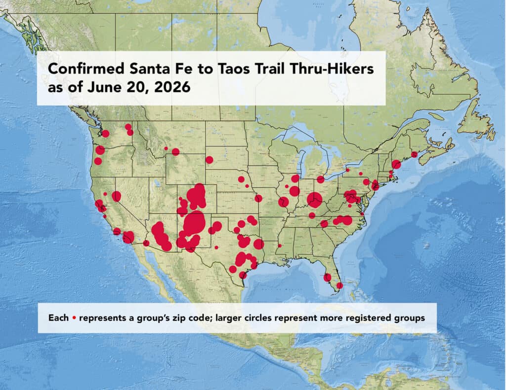
Total registered hikers (as of June 19, 2026)
- 207 registered groups
- 404 registered people
- Average group size: 1.95 people
New Mexico hikers (June 19, 2026 data here and below)
- 65 groups
- 126 registered people
- 32.0% of groups
- 31.8% of people
Out-of-state U.S. hikers
- 138 groups
- 270 registered people
- 68.0% of groups
- 68.2% of people
Top states after New Mexico by groups
- Texas: 33 groups (16.3% of groups), 56 people (14.1% of people)
- Colorado: 30 groups (14.8% of groups), 54 people (13.6% of people)
- Arizona: 16 groups (7.9% of groups), 41 people (10.4% of people)
- California: 15 groups (7.4% of groups), 31 people (7.8% of people)
International hikers
- Australia: 4 people
- Mexico: 2 people
- Netherlands: 1 person
Elevation profile of the 2026 route of the Santa Fe to Taos Trail
Maps and route
See the route page and individual section pages for details on the route and turn-by-turn directions for the route. (6/22/26: Route page is old info and needs an update)
Presentation at the Los Alamos Mountaineers monthly meeting at the Los Alamos Nature Center Planetarium, Tuesday, October 28th
Huge thanks to the Mountaineers and the Nature Center for this opportunity.
Plaza to Plaza in 52 photographs
Each photograph is from one of the 50 subsections that make up the route.


 of Section 6 of the Plaza to Plaza Thru-Hike")


