


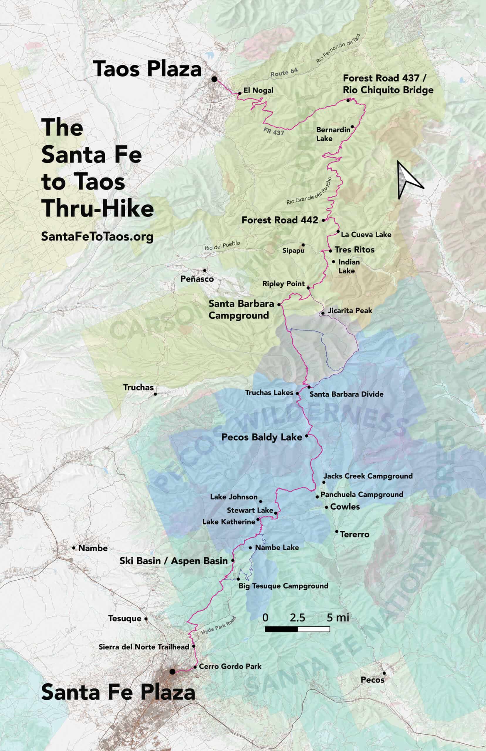
The Santa Fe to Taos Thru-Hike goes from the Santa Fe Plaza all the way to Taos Plaza over the Sangre de Cristo Mountains of northern New Mexico. It is 132 miles long, spans four counties – Santa Fe, Rio Arriba, Mora, and Taos – and crosses the Santa Fe National Forest, The Pecos Wilderness, and Carson National Forest. The full route has 35,000 feet of cumulative ascent and descent, as both plazas are at 7,000 feet elevation.
The route is over ten years in the making, scouted and refined by Pam Neely beginning around 2014, and then first completed as a thru-hike in 2018. It has been refined several times to optimize safety and access to water. It is still being refined, with a new alternate route to be announced late this year.
Recording of the Q&A and guidebook launch event at Travel Bug on May 31st
TIMESTAMPS:
1:30 Start of the presentation “The most common questions about the Santa Fe to Taos Thru-Hike”
3:13 What’s a thru-hike?
3:25 How long does it take to do the thru-hike?
5:05 How much water is on the route?
8:39 When is the best time to go?
10:20 What are the trail conditions like?
13:37 About the weather and the altitude
14:56 How fit do I need to be to do the thru-hike?
15:35 What gear do I need?
16:27 What resupply options are there?
19:51 end of prepared Q&A part of the presentation
19:51 About the Santa Fe to Taos Thru-Hike as an organization
22:25 Me asking if there is any interest in guided hikes. Please email me (contact@santafetotaos.org) if you are interested.
23:27 Beginning of audience questions
23:30 How do you get back to your car if you start at Santa Barbara?
25:48 Adding the route to the popular hiking apps
26:47 What’s the fastest finish time?
27:42 Is the trail marked?
28:00 Is there a route for biking?
29:23 Is there any cellphone coverage?
29:50 Can you take your dog the whole way?
30:31 Which direction has the lesser elevation?
31:28 Could you describe the route? (Lots of people really liked this part, and it was fun. Especially the bit about the bedspring.)
44:40 Are there any places you have to ford? (Walk through a stream/river)
45:06 How many times have I done the thru-hike
45:30 Are there sections that are good for skiing?
46:43 What is the national map?
Maps and route
See Gaia GPS maps documenting every step of the thru-hike. A complete zipped GPX file of the route is here. Or see the route page and individual section pages for details on the route and turn-by-turn directions for the route.
Plaza to Plaza in 52 photographs
Each photograph is from one of the 50 subsections that make up the route.


 of Section 6 of the Plaza to Plaza Thru-Hike")


