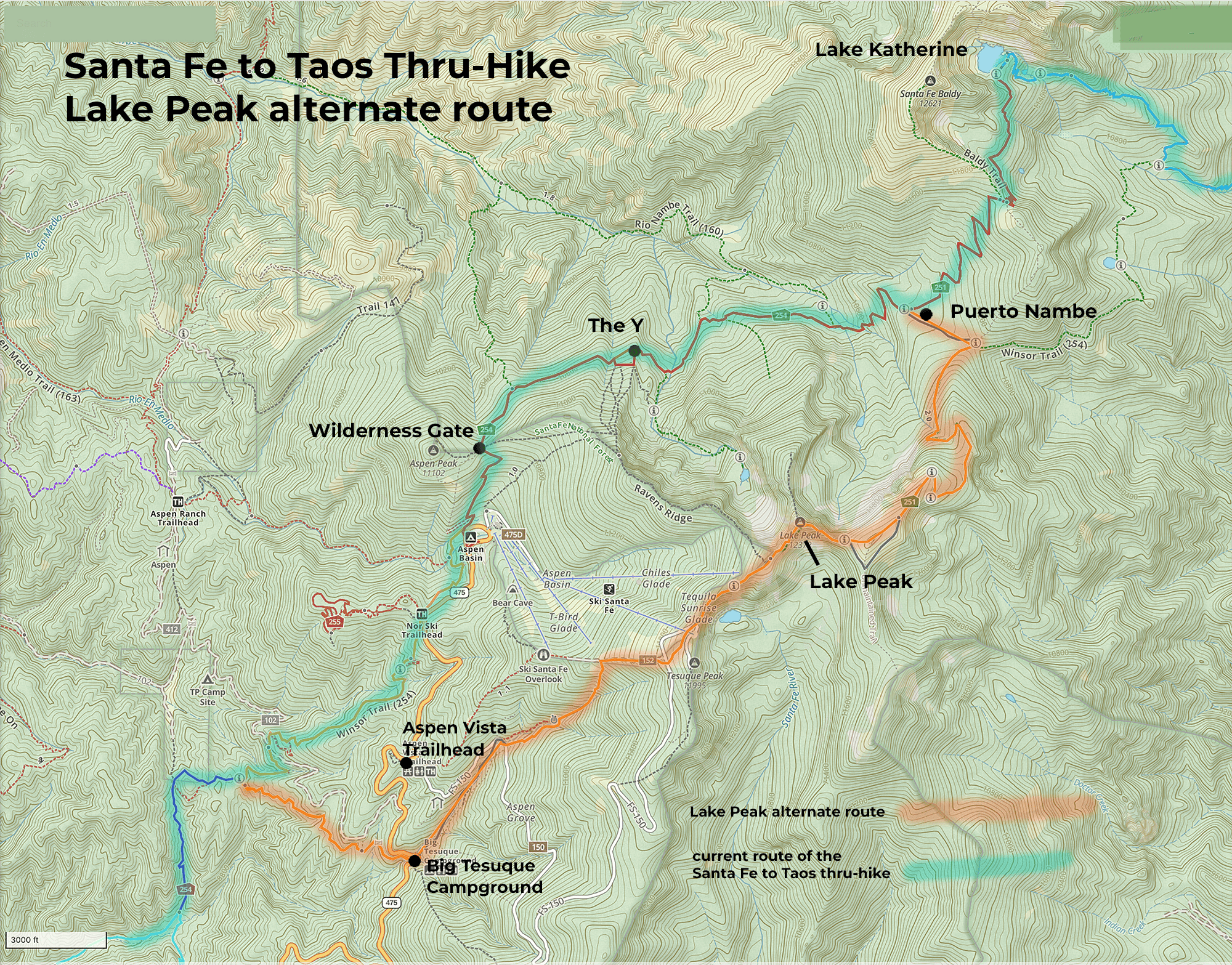
Lake Peak alternate route
Printable version of this map (8 MB). All the images on this page can be clicked if you want to see much larger, more detailed maps.
Link to Gaia map of this alternate route
9.45 miles. 4,026 feet ascent, 1,985 feet descent.
Water available for about 1.5 miles of this along Big Tesuque Creek. Possible water at Tesuque Peak from the infrastructure associated with Ski Santa Fe (not verified; don’t count on it). No water from where you start on the ridgeline all the way down into Puerto Nambe. There are several small rills (a “rill” is a tiny stream about 1-2 feet wide) on the far side of Puerto Nambe and going down from Puerto Nambe.
Several places you could camp overnight, including Big Tesuque Campground if you got a reservation. Route is almost entirely along Tesuque Trail (152) and then along Skyline Trail (251). Incredible views along the four peaks, but be mindful of the weather. This is not a route for bad weather.
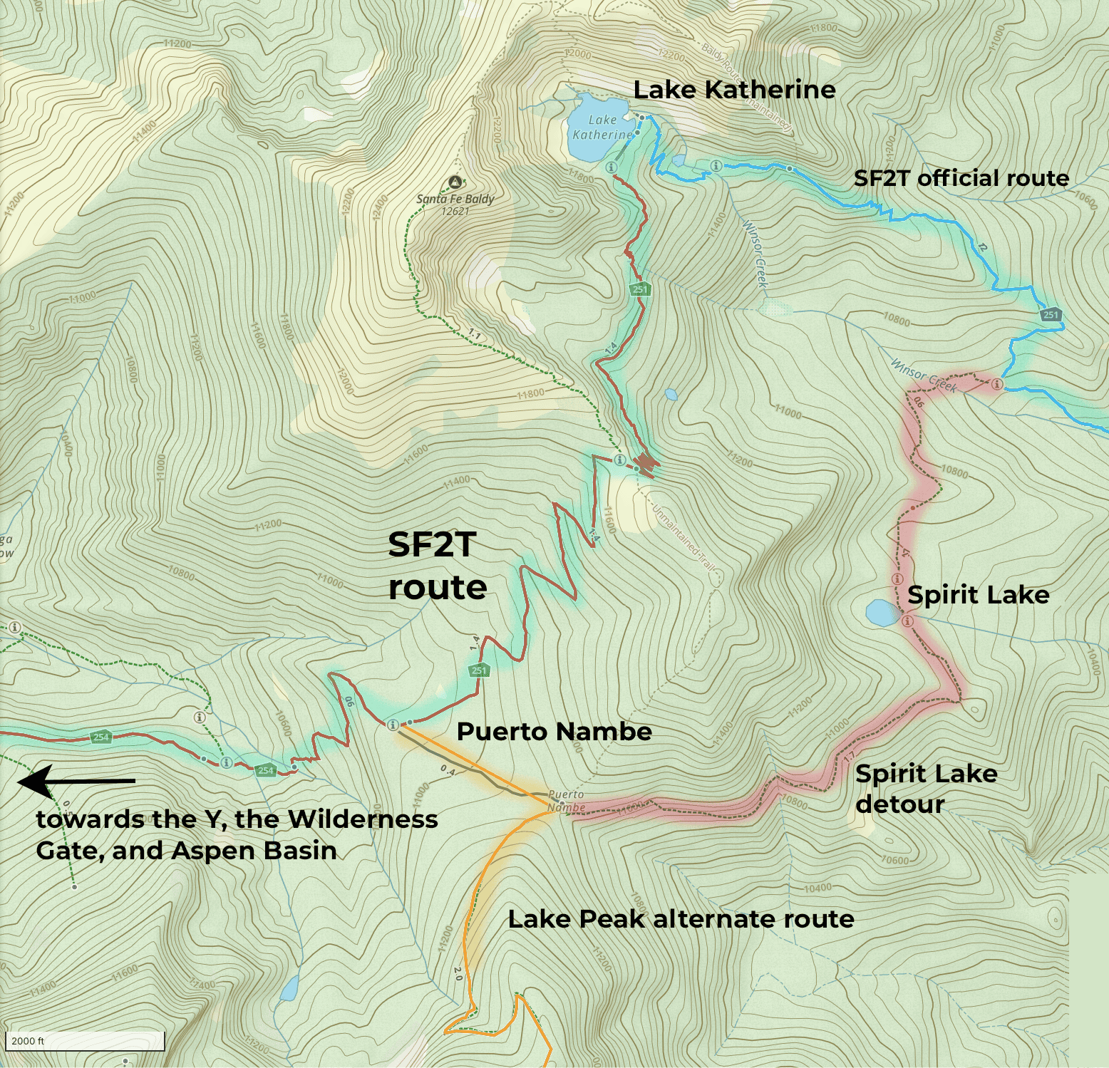
Details of the Lake Peak alternate route
The fundamental question with the route of the thru hike has never been, “Is there a way?” (to get to Santa Fe to Taos over the mountains). It’s “What’s the best way?”
Then there’s the question of what’s “best”? The most beautiful? The safest? I think about this a lot. One of the things I worry about is safety. One of the things I enjoy thinking about most is beauty.
So here’s an alternate route. Instead of going up Winsor (254), all the way from where it connects with Juan Trail 399 in Section 1, you can take Trail 152, Tesuque Trail up into Big Tesuque Campground.
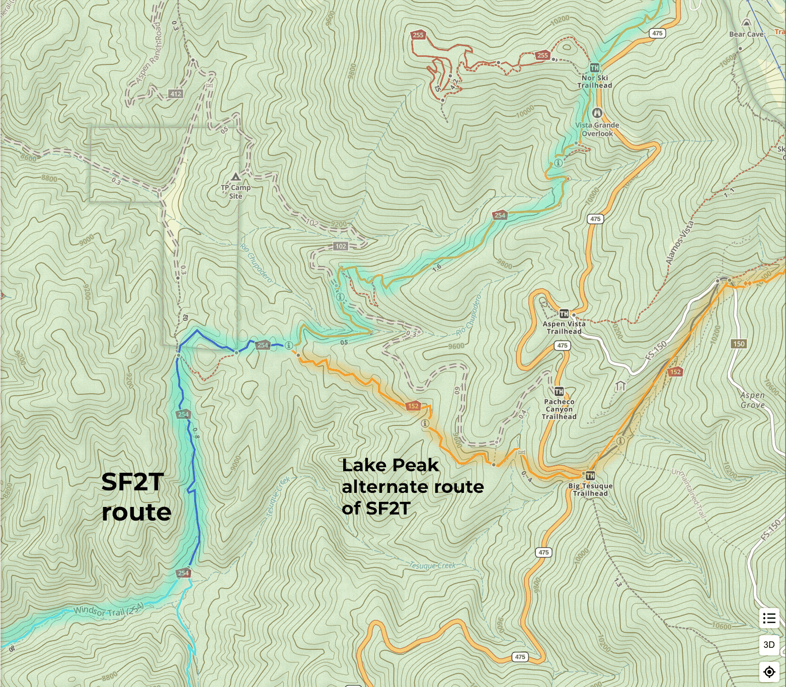
Then stay on 152 up, along Big Tesuque Creek (it’s not very big anymore, but it’s still a water source). You will cross Aspen Vista “trail”, which is technically forest road 150.
You can walk on FS 150 all the way up (and that’s the way most people go). But I’m sending this alternate route up 152, through the woods a bit, to come out again on FS 150 about a mile or so later.
You will come very close to the “headwaters” (ha), or origin point of Big Tesuque Creek on your way up. Where you cross near the beginning of Big Tesuque Creek, or wherever along the way the creek starts getting too small to get water from, stop there. That’s your last reliable water source on this alternate route. So fill up whatever you carry water in, AND drink a liter. There is no water along the ridgeline, or all the way down into Puerto Nambe. There is water on the far side of Puerto Nambe, or at Spirit Lake. If you are heading to Katherine (and sticking to the official route of the thru-hike), there’s no water until Lake Katherine unless you make a quick 5-10 minute detour and zip over to one of the little rills on the far side of Puerto Nambe.
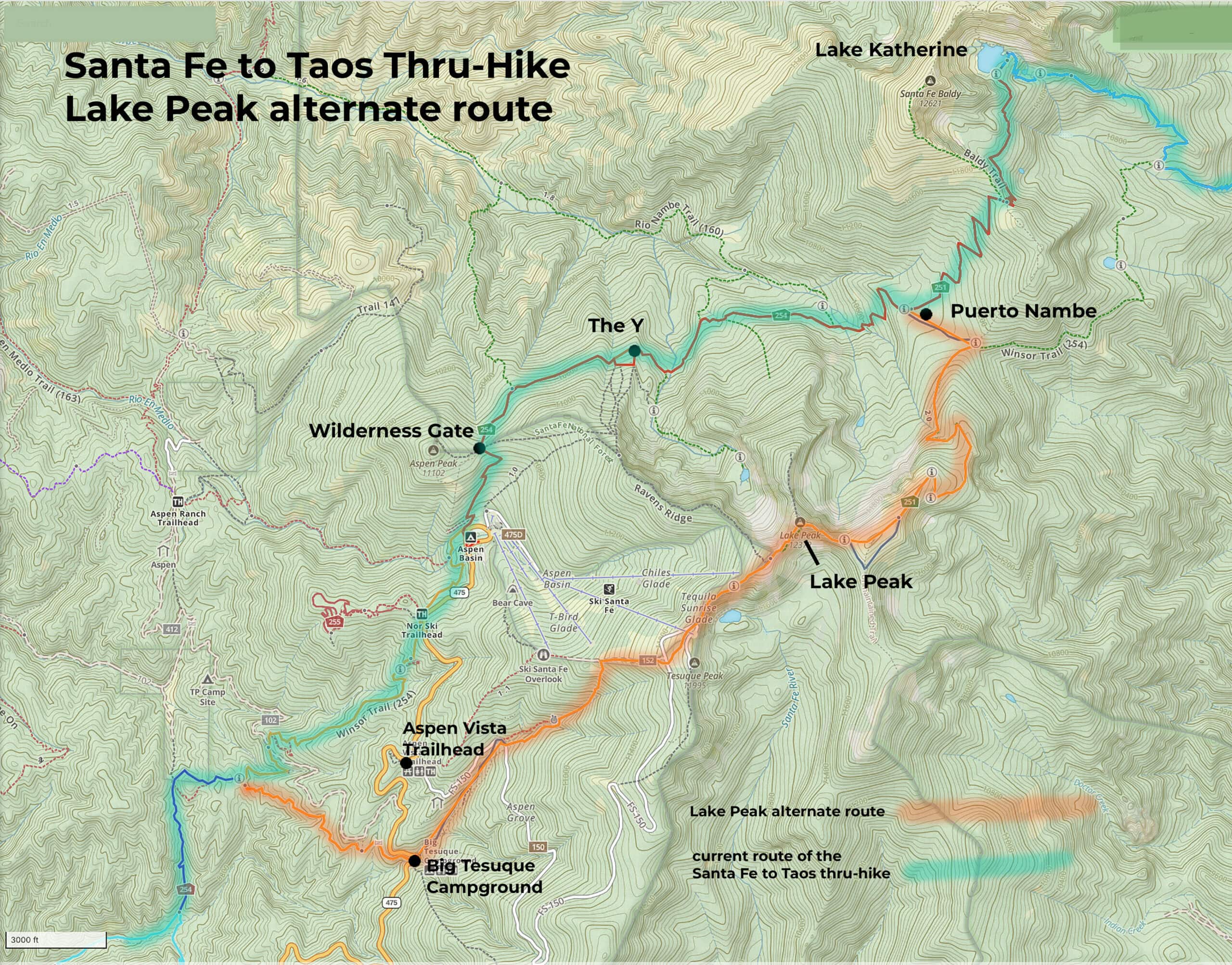
Back to this alternate route: Stay on Trail 152 / Tesuque Trail until you are near the top of Tesuque Peak. You will get on a service road and FS 150 near the top. As you approach the top of Tesuque Peak you will be around all the infrastructure of Ski Santa Fe. You will probably get glimpses of all the satellite and comms towers at Tesuque Peak. The comms towers and the peak are interesting, including a cool view looking down on the forbidden Santa Fe Lake (it’s a municipal water source, so it’s protected. It’s a $2,000 ticket if you decide to test if that’s enforced.) But the trail you want (Skyline / 251) will be on your left as you come up towards all the buildings at the summit.
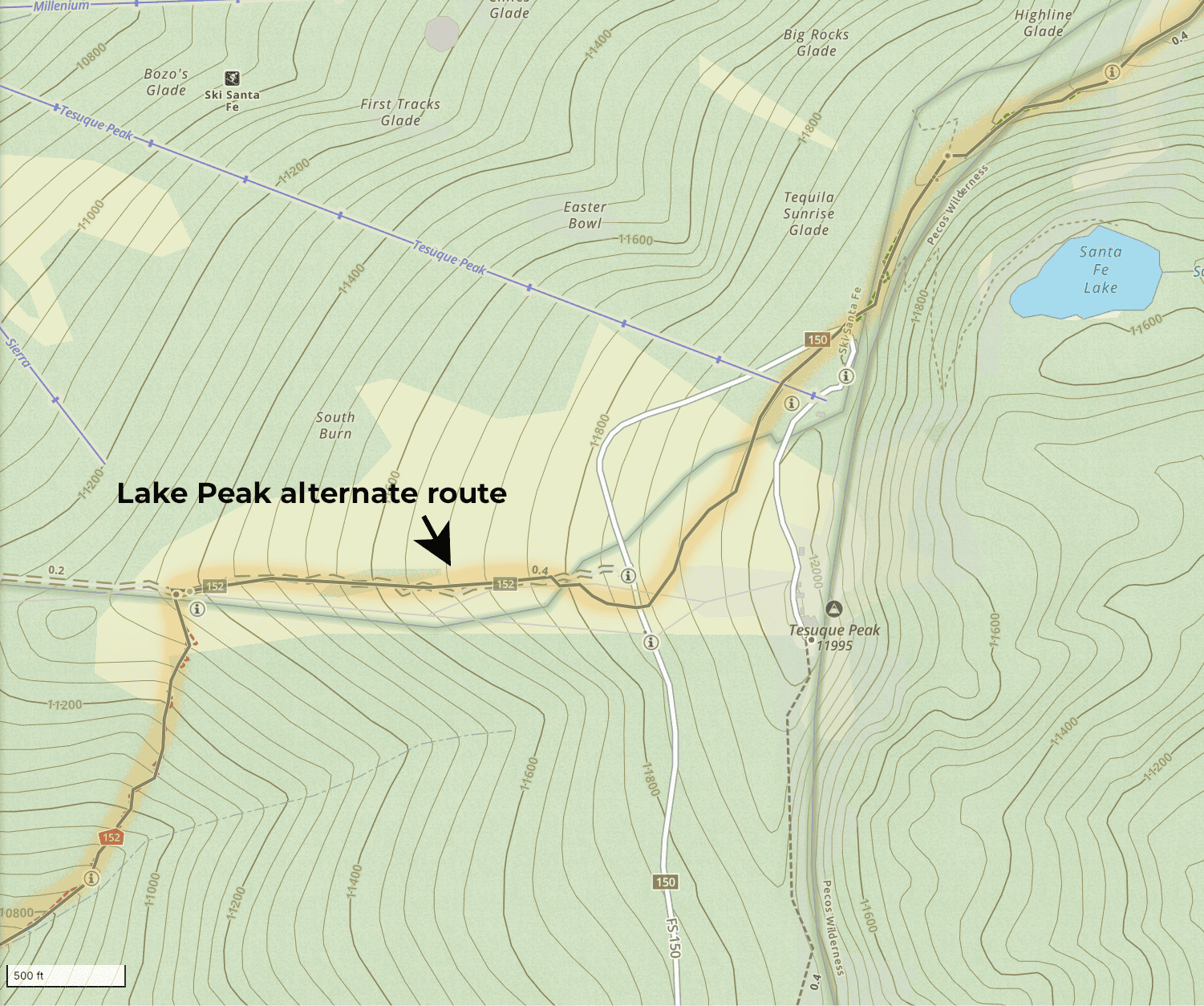
Once you’re on Skyline / Trail 251, you will head north/northeast along a ridgeline. You’ll be heading towards and walk over Deception Peak, Lake Peak, and Penitente Peak on Skyline Trail 251. The views are epic. The wind and the weather can be pretty epic, too. Be careful. Use good judgment.*
SIDEBAR: IF YOU HIT WEATHER ALONG THE RIDGELINE *If the weather turns on you while you are near Tesuque Peak, skip the ridgeline and just follow the Ski Basin service roads or ski trails down towards Aspen Basin and the parking lot there and the Winsor Trail trailhead. Then take Winsor Trail north/northeast and continue along the route of the thru-hike along Winsor Trail.
*If the weather turns on you while you are up on the ridgeline, take Raven’s Ridge trail (near the southwest side of Deception Peak) down. That 1.2 mile trail will bring you down to Wilderness Gate and Winsor Trail, where you can pick up the official route of the thru-hike. Do not take the side trail that heads northwest from Lake Peak (along the ridgeline), because that doesn’t go down; it just takes you to another peak and view.
*If the weather turns on you while you are past or near Penitente Peak, just keep going along 251 / Skyline towards Puerto Nambe. Do not take the unmaintained trail that goes down, south/southeast from Penitente. That trail is dicey and it will not take you “anywhere” – just to a dead end on the border between the Pecos Wilderness and Santa Fe National Forest.
END SIDEBAR
Continuing the instructions for the alternate route… After Penitente, you will go down 1,225 feet, off the ridgeline and into the woods, still on 251 until you walk into the lovely sprawling field area called Puerto Nambe. It is 2.1 miles from Penitente Peak to the intersection of Winsor / 251 and the Puerto Nambe area.
Take the left onto Winsor Trail if you want to go towards Lake Katherine, Santa Fe Baldy, the Y, and the “official” route of the thru-hike. Or take the left and stay on Winsor Trail (254) and head towards Spirit Lake. Spirit is smaller and less dramatic than Katherine, but also *far* less crowded.
Of course, any time you even think about getting up on a ridgeline, consider the weather. Also consider what the weather will be like three to four hours later, and even six or seven hours later. Lightning is “a thing” around here.
I like this route because it might avoid a hiker/mountain bike collision on the part of Winsor below the Norski area. I also like it because it’s along Big Tesuque Creek, so it adds a few miles of being directly along a creek/stream/rill to the route of the thru-hike. And, of course, the views and experience of being up on Deception, Lake, and Penitente Peaks are ah-mazing. Tesuque Peak is very cool, too. If the weather is good, this route is just phenomenal. Get ready for a heck of a climb though. It’s 4,065 of elevation from Big Tesuque Campground to Puerto Nambe via this 9.45 mile route.