The Santa Fe to Taos Trail and the Rio Grande Trail
The Rio Grande Trail (RGT) is a proposed multi-use trail envisioned as a continuous route along the Rio Grande from Colorado to Texas. Authorized in 2005, the project remains in development and is currently evaluating alignment options between Santa Fe and Taos.
The Santa Fe to Taos Trail does NOT want to be part of the Rio Grande Trail.
Last year, representatives of the Rio Grande Trail Commission approached SF2T about incorporating portions of the Santa Fe to Taos Trail alignment into the proposed RGT route.
During discussions, SF2T leadership asked the RGT team whether there would be any benefit to the SF2T in being incorporated into the Rio Grande Trail. No clear benefit was identified. SF2T subsequently communicated that it does not want to be part of the RGT.
The Santa Fe to Taos Trail was independently scouted and developed over the past decade with a specific stewardship vision: to create champions for wilderness and nature. It has an active user base (65 people did the SF2T last year; at least 300 people will do it this year). It has a guidebook, a volunteer base, and a conservation framework. It is a registered 501(c)3. SF2T is a nationally recognized trail. It is already experiencing rapid, almost unmanageable growth.
One of the other reasons SF2T does not want to become part of the Rio Grande Trail is because RGT planners have continually dismissed and devalued the work of Pam Neely, SF2T’s creator. They did this in meetings last year, at an event last year when a senior RGT planner said to Pam “if you’re not building trails, why do you need any money?”, and they are currently using the gpx files from the SF2T Trail website in their alignment survey materials without acknowledging the existence of SF2T anywhere in those materials.
The RGT’s Santa Fe to Taos alignment survey
The Rio Grande Trail is currently seeking input on three possible routes, or “alignments” between Santa Fe and Taos. One of those alignments – the east/Orange/”Option 3″ alignment – uses 86% of the Santa Fe to Taos Trail’s route. Yet at present, the SF2T Trail and its existing stewardship framework are not reflected anywhere in the RGT alignment materials.
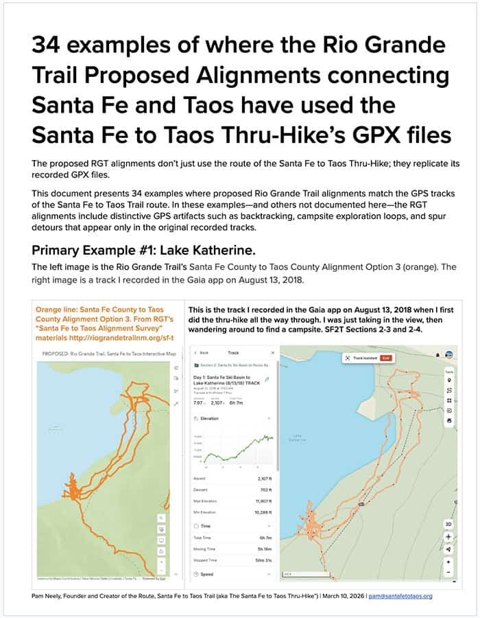
The carousel below shows several examples in the RGT’s survey’s online map where the gpx tracks Pam Neely made while scouting and documenting the route for SF2T reappear in the RGT arcgis map. If you bring up the RGT alignment map in a browser and zoom way into Lake Katherine or Pecos Baldy Lake (among many other places), you will see these “artifacts” from where Pam was walking around after having forgotten to turn her tracking device off.


Beyond the issues with the co-opted gpx files, there are several reasons why the SF2T Trail does not want to be part of the Rio Grande trail.
- Overuse and ecological capacity
The SF2T is already experiencing rapid growth. Increased traffic — particularly multi-use traffic — will further strain sensitive alpine lakes and riparian corridors that are already likely to see overuse this year. - Use compatibility
Bicycles are not permitted in the Pecos Wilderness, and some sections near Santa Fe are not designed for mixed high-volume bike and foot traffic. - Existing conflict areas
Sections such as Winsor Trail already experience considerable friction between user groups. Increased designation-driven traffic will only intensify these conflicts. - Mission integrity
The SF2T was built around a specific stewardship model and conservation ethos. Incorporation into a broader multi-use corridor will alter its identity, the culture on trail, and its long-term stewardship. The RGT is already doing this, right now, by using the SF2T’s gpx files and route without acknowledging SF2T’s existence in their alignment survey materials. They are already acting like the SF2T Trail doesn’t exist.
The Rio Grande Trail Commission had been soliciting feedback on three possible alignments for the RGT between Santa Fe and Taos. Its survey closed March 25th. SF2T supports one of the three alignments, in the western/purple alignment option #1. While the west alignment is the best straight choice, (just remember “West is best”), SF2T believes the most appropriate alignment approach would be to:
- Use the Western/Purple/”Option 1″ alignment north of Big Tesuque Campground in Santa Fe National Forest
- Use the Middle/Light Blue/”Option 2″ alignment south of Big Tesuque Campground
- Do not use the Eastern/Orange/”Option 3″ alignment at all, because that uses approximately 86% of the route of the SF2T Trail
The “west is best” alignment would allow the Rio Grande Trail to remain closer to the Rio Grande while avoiding the existing SF2T route.
Click here to see 34 examples of where the RGT alignments appear to use SF2T gpx files.