horizontal summary map 121824-for-summary120second-video
horizontal summary map 121924-for-summary120second-video-sixsections
horiz-summary-map-121924-for-summary120sec-video-section1-highlight
horiz-summary-map-121924-for-summary120sec-video-section2-highlight
horiz-summary-map-121924-for-summary120sec-video-section3-highlight
horiz-summary-map-121924-for-summary120sec0video-section4-highlight
horiz-summary-map-121924-for-summary120sec-video-section5-highlight
horiz-summary-map-121924-for-summary120sec-video-section6-highlight
horiz-summary-map-121924-for-summary120second-video-2wks10miles
horiz-summary-map-121924-for-summary120second-video-seriesofdayhikes
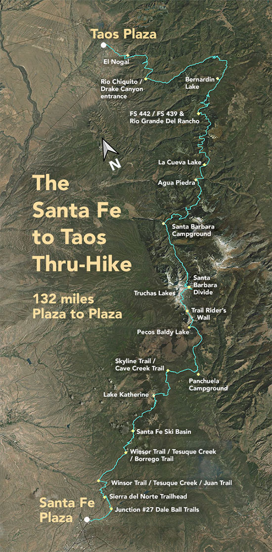
The Santa Fe to Taos thru-hike goes from the Santa Fe Plaza all the way to Taos Plaza over the Sangre de Cristo Mountains. It is 132 miles long, spans four counties – Santa Fe, Rio Arriba, Mora, and Taos – and crosses the Santa Fe National Forest, The Pecos Wilderness, and Carson National Forest.
Maps and route See Gaia GPS maps documenting every step of the thru-hike. A complete zipped GPX file of the route is here . Or see the route page and individual section pages for details on the route and turn-by-turn directions for the route.
Some favorite photographs:
Santa Fe River Trail
along the Santa Fe River Trail
Arroyo Polay
Chasing Dreams in Arroyo Polay
Field near Winsor Borrego intersection
Field near Winsor / Borrego Trail intersection
Truchas Peaks from Beatty’s Trail
Truchas Peaks from Beatty’s Trail
Kit Carson Road
View from Kit Carson Road


